During most Mays in the Northwest, there is a several-day period of warm weather, driven by the strengthening sun and a favorable atmospheric circulation (high pressure and offshore-directed winds).
During such periods, the western lowlands can surge well into the 80s, while the Columbia Basin warms well into the 90s.
Such a period is ahead starting this weekend.
Just to give you some perspective, below is a plot of the warmest temperature each year in Seattle for the period 5-25 May. Most but not all years have a least one May day above 80F, with a number of years seeing temperatures surge about 85F. Interestingly, there is no upward trend in warm days over the period of record.
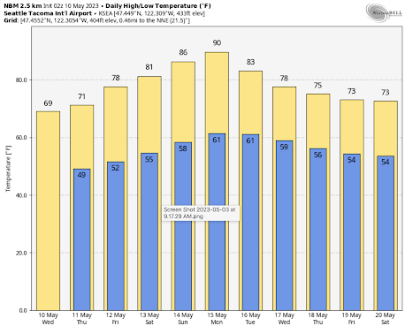
The latest forecast from the NOAA/NWS National Blend of Models, which combines the forecasts of many modeling systems statistically, predicts the mid-80s over the weekend in Seattle, surging to 90F on Monday.
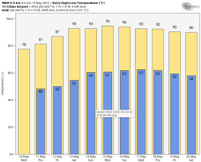
The Tri-Cities will be firmly in the 90s starting on Friday and will stay there for days (see the prediction for Pasco below).
The origin of this warm bounty will be the development of a ridge of high pressure along the West Coast, replacing the low-pressure trough that has hung around FOREVER.
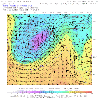
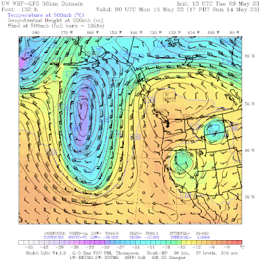
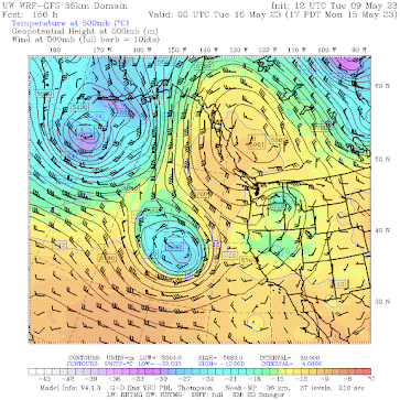
Let me illustrate the changes by showing you a series of upper-level maps (500 hPa pressure, about 18,000 ft).
By Friday at 5 PM, an upper-level ridge, accompanied by warm (yellow) temperatures has built northward from California into southern BC.
The pattern gets complex by Sunday at 5 PM, with high pressure/heights over British Columbia and eastern (from the east) flow over the Northwest
This pattern is in no hurry to move out, with the British Columbia high-pressure ridge still in place 24 hr later.
As we get closer, I will provide more details on the warmth, which will be a welcome relief from the uber-cool Spring we have had so far this year.
.png)
I see the record high on May 13 (Monday) is 92, and the normal high is 65 (this according to the "weather graphs" for Seattle on the NWS Seattle office website). Not possessing the time to make a spreadsheet of normal and record highs for each day of the year, I am wondering is a 27-degree spread between normal high and record high is one of the largest such differentials of the year? In the winter months, those differentials are usually 15 degrees or less.
ReplyDeleteNice observation and probably correct, as you noted during summer/winter the differential isn't as extreme. That leaves Spring and Fall as better options. Since temps lag in spring I doubt there is anything greater in Fall.
Delete27 June 2021 comes to mind, with a normal high of 73 and a record of 108, a 35 degree delta.
DeleteI would prefer the uber-cool Spring last forever...
ReplyDeleteMove to Alaska
Deletesame. this is not a welcome relief imo
DeleteNoooooooooooooooooooooooooooooooooooo!!!!!!!!!!!!!!!!!!!!!!!!
DeleteMy only regret is that it'll get those silly cottonwood tress to start snowing all over my yard, gutters, etc. But bring on the swimming season!
DeleteI would as well. You can put on more layers when it's chilly, but take off only so much when it gets hot. Late spring until September is a waiting time until fall because the warmer weather enervates me, but cooler weather makes me perk right up.
DeleteI remember back in the 80's the TV weatherman Larry Schick described this as an Omega block. He said "oh boy, that sounds kind of scary, but it is good". Looking at you pics this looks like it could be.....and Omega block! Oh my!
ReplyDeleteCliff- is this in fact an Omega Block? Is an Omega Block a special kind of high pressure situation or just any old high pressure that sets up strong and looks like an Omega symbol?
Also, early June has been very wet and cold the last 2 years. Perhaps related to La Nina?
Is there reason to think early June will be good this year? We have an annual camping trip that time of year.
Thanks!
NOAA Climate prediction for June-August is warmer and drier than normal:
Deletehttps://www.cpc.ncep.noaa.gov/products/predictions/long_range/seasonal.php?lead=2
But as Cliff has noted many times, these forecasts are not very reliable.
June Gloom.
DeleteThe current Weather Channel forecast is going for monthly record high minimum temps at BLI. Hopefully there will be sufficient offshore flow to keep dew point temps in check to some extent.
ReplyDeleteWelp. It's going to get hot. Still, what a fine day. Aren't you all glad you live here?
ReplyDeleteBased on the ksea forecast chart you show that 90 degrees appears to be the earliest on record seattle would hit 90 (based on what other local news sources are reporting as the record). Isn't that potential record event at least noteworthy? Smashing some new all time heat record has become the norm - last year's record # of 90 degree days, the 2021 all time record smashing heatwave, etc. Why isn't the record breaking potential of this upcoming heatwave even mentioned in your article?
ReplyDeleteThe temperatures in Seattle are unlikely to hit 90F during this event. Not the right set up for extreme heat at the airport or near the Sound for reasons I will discuss in my next blog.
DeleteI work outside. Anything over 70 is too hot.
ReplyDeleteIt wouldn't be so bad if there was a gradual increase in temp heading into summer for the sake of acclimation. Plus, these early heatwave are accompanied by cold water temps.
DeleteThen there is the fact that most of those excited about the heat are higher income office workers where actually experiencing the heat is an optional novelty. There is still an enhanced probability they will complain about the heat as they transfer from their air conditioned residences to their air conditioned cars to their air conditioned offices. They will be all over social media about how that 10 foot walk might as well been a trek across Death Valley. However, they will also be eager to call their local noise ordinance enforcement if a job site starts early to try to get some production before it gets too hot.
That's a good analysis. It's amusing to me to hear the howls of protest when I say I'd prefer cooler/colder weather, as if, by merely expressing that preference, I magically could make it so. Would that I had such power!
DeleteGiven that a lot of factors affect temperature (like the presence of clouds), I think comparisons and predictions based on numerical outlier "record highs" from year to year can lead to misunderstandings (and misstatements) about trends. Last summer we had a humdinger - noteworthy - hot streak. But the event was rather short-duration. Before long, last summer returned to 'range of normal' here (and I think, most places on the west side of the Cascades). However, that spike distorted the statistics, numerical averages. If a 30-day period is moderate (even cool), it doesn't take a lot of hot days to affect "average daily temperature." There's also a big difference between "numerical average" and other measures: "mean," "median." When folks talk about "average temperature" I suspect that in most cases they're referring to "average highs."
ReplyDeleteOverall, as an observer, the phenomena that seems to make the biggest difference in temperature is "presence of clouds." Cloudy days are always cooler than clear ones (and that applies to overnight lows, too). Length of day (hours of sunlight) are a big factor too. I'd love to know how many factors drive the better models, and how those factors are weighted. Maybe this will be a topic at the weather workshop event. Years past I'd have made the trip, but Seattle's being what it's become don't feel particularly safe visiting the waterfront area. Tragic.
Too few hours of darkness when we could use them to cool off after a hot day.
DeleteWaPo says : "The heat dome’s projected intensity would be near historic values in summer, let alone spring.
ReplyDeleteTemperatures are likely to be shy of those extremes because the event is happening earlier in the year than in 2021. But temperatures reaching or breaking a range of 94 to 104 degrees are still likely, putting peak temperatures between 18 to 36 degrees above normal.
That this heat dome is coming just shy of two years after the last is exceptional. The 2021 event was deemed a one-in-a-thousand-year occurrence.
Now, “these type of events are forecast to occur in this region once every decade or even more often,” wrote meteorologist and climate specialist Jeff Berardelli."
The WaPo story is simply nonsensical. Easy to disprove....
DeleteYour right Cliff, some "Climate Specialists" who get there funding from outlets that are pushing the warming narrative will latch on to a 4 or 5 day warm streak and say it's the new norm, but forget that it's been well below "average" for 5 or 6 months. I never get this once in a decade, 500 or 1000 year event cycles because we've only been keeping records for a little over 100 years. People forget that while we had our 2021 heat wave that it was 40 to 50 degrees below average over the rockies at the same time.
ReplyDelete