Call it a "smoke storm" perhaps, but the well-forecast onslaught of mainly British Columbia wildfire smoke came in with a vengeance.
But before I discuss the details, let me note that our new-found ability to predict the generation and movement of wildfire smoke has become extraordinarily good. Good enough to help warn vulnerable populations days in advance.
And our ability to predict the winds that can initiate and expand wildfires has also developed rapidly. Lahaina and similar wildfire disasters don't have to happen.
The visible satellite imagery this afternoon shows both the smoke over portions of the Northwest as well as the plume of moisture associated with Tropical Storm Hilary (see below). And if you look closely on the upper level part of the image you can see clear skies associated with clean ocean air.
The smoke-free air will be here tomorrow morning.
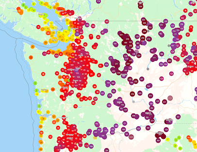
The PurpleAir air quality map around 3 PM shows poor air quality (purple colors) over eastern Washington and seriously degraded air quality (reds) over much of western Washington and the Willamette Valley.
Better conditions over NW Washington and along the coast.
What was so startling about this situation was the rapid deterioration around noon over the western interior.
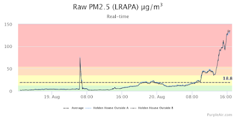
Smoke initially came in aloft, but it mixed rapidly down to the surface as the temperatures rose this morning. To illustrate, take a look at the small particulate concentrations today near Boeing Field in Seattle (below).
Wow... at 8 AM, the PM2.5 (small particle) concentrations were around 15 micrograms per cubic meter but rose to about 120 by mid-afternoon.
I don't go running when it is above 75.
Why did it go up so quickly?
Because the atmosphere and the movement of smoke particles are highly three-dimensional.
Let me show you.
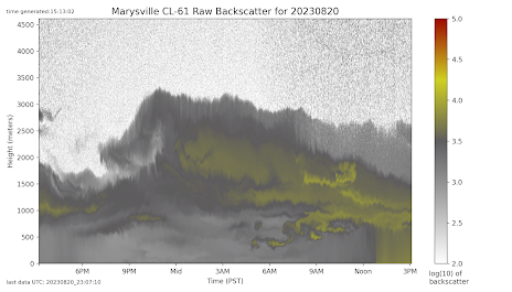
Puget Sound Clean Air Agency has acquired devices called ceilometers that can measure the distribution of smoke and particles above a location (it uses upward-directed laser beams to sample the smoke distribution above).
Observations from the ceilometer at Marysville, Washington (below) showed smoke coming in aloft overnight, with the yellow colors being the highest concentrations.
But look at what happened after noon (time increase to the right). YIKES. The yellow colors extended all the way to the surface...and thus our air quality degraded.
Why did this happen? It had to do with vertical mixing.
This morning we had cold, dense air near the surface, which resisted mixing with the warmer smoky air aloft. But the heating by the sun this morning warmed the surface, resulting in vertical mixing that deepened over time. Warming air near the surface causes low-level air to become more buoyant, with a tendency to rise. Air from above sinks to take its place.
This process is called convective mixing and helps bring the smoke aloft down to the surface.
The Future
Our best smoke model, the NOAA HRRR Smoke, paints an encouraging trend for the next day.
At noon today, there was lots of smoke in the region (see near-surface smoke prediction at that time).
By 11 PM tonight (Sunday), onshore flow is eroding smoke along the coast and Hilary rain and wind are lessening smoke over southeastern Oregon.
By 5 PM tomorrow, much of western Washington and Oregon are smoke-free and big improvements have occurred over eastern Washington.
And by Tuesday morning, western Washington, southwestern BC and coastal Oregon are completely out of the murk.
Most of this smoke has come from British Columbia. Warm/dry conditions contributed but even more important has been the poor maintenance of BC forests and the completely inadequate resources provided by our northern neighbor for thinning, prescribed burns, and sufficient fire-fighting resources.
A topic for another blog.


Cliff, do you expect the Northeastern Part of WA state to remain in smoke or have the clearing later in the week?
ReplyDeleteThanks for the update Cliff. I could see the vertical mixing taking place near my home in Cle Elum. Started off Friday morning with smoke aloft and then once the sun started warming the atmosphere the smoke began drifting down to the surface very rapidly. Looking forward to your blog about BA forest maintenance.
ReplyDeleteIts frustrating to see this being one of the key causes. I watched King 5 yesterday and they have a segment with Hilary Franz r.e. the Spokane fires and only mention "climate change" as the cause. To me this is extreme dishonesty and attempting to deceive the public. Regardless of any other factor, if forests are overflowing with fuel then they will burn and decades of irresponsible fire suppression has left us in a dangerous state.
The Gray fire near Medical Lake burned in an area of mixed forest and range land where "forest mismanagement" was likely not an issue. It was simply very dry and windy following a long period of warm, dry weather.
DeleteWxman...this is mainly a grass/range fire and a "long period of warm, dry weather" is immaterial. Just vegetation drier within hours, particularly with strong winds. Grass/range fires are highly assoiciated with human-introduced invasive grasses such as cheatgrass...cliff
DeleteGreat post. I'm getting married outside this coming Friday in Puget Sound - do you forecast smoke will return to Sound area this coming Friday? Thx!
ReplyDeleteAside from some protected areas, BC "forests" are largely one giant clearcut in various stages of regrowth. They possess a vastness beyond most Washingtonians' comprehension. We're talking 149 million acres. For comparison, the entirety of Olympic National Park is a bit less than one million acres. Fireproofing at this scale would dwarf Canada's mobilization for World War III. There's the added problem that fireproofing is largely a myth. Thinning does the reverse, by drying out the forest floor earlier in the summer via more sunlight, allowing more wind to fan the flames, and requiring a maze of logging roads providing easy access to human firebugs. Prescribed burns in drier, fire-adapted stands would have to be done every few years at tremendous expense and would be unsuitable for wetter forest types. We delude ourselves into thinking that we can stop these big fires from happening. There are things that we can do to harden specific, vulnerable properties at a very small scale, but that's it. Nearly everything else is timber industry propaganda to up the cut.
ReplyDeleteI do not think you are correct...and there is an extensive literature and numerous reports, including from the BC provincial government that state the opposite. Thinning and proscribed fire are essential tools to restore forest health...particularly on the eastern side of the region.
DeleteYes, these bigger fires are a new phenomenon. They are happening only recently because of fire suppression in the past, invasive species, carelessness, and perhaps very slightly affected by climate change. Thinning and proscribed fire are not the problem. Prior to the start of fire suppression, there were fires (not as big as the ones now) that caused smoke and all the disruption it did, but nowhere near the scale of these fires today and certainly did not happen every single year we have La Nina.
DeleteYour last sentence could apply to most of the western US as well. The Fort McMurray fires in northern BC devasted much of that community, and could have been mitigated to a large degree if they had managed the surrounding forest in the preceding years.
ReplyDeleteAnother great resource for smoke predictions -- especially for fires outside HRRR's domain to the north -- is https://weather.gc.ca/firework/index_e.html
ReplyDeleteAccording to the NY times, Hilary passed right over San Diego. Was there still a definable eye at that point?
ReplyDeleteHere we are in another summer where we thought we'd escape the smoke- but didn't. Washington currently has the country's worst air... Isn't it about time we had a wetter-than-average summer? Perhaps, they all seem dry to me now because I moved here in the 70's when there was a run of wetter-than-average summers...
It is about 4:30pm and that smoke is 'hanging in' around here on Sinclair Inlet. Winds have been out of the north, the south, and sometimes mostly still.
ReplyDeleteWe run two indoor HEPA units (floor sized, purchased at Fred Meyer) in our large indoor area downstairs, as well as smaller Lavoit units in the upstairs living quarters, and have an indoor purple air device which is nicely paired with an outdoor monitor a bit closer to the water -- this gives a nice data point about how well such filtering works, and how important it can be... https://kitsap.s3.us-west-2.amazonaws.com/public/purple2.PNG
ReplyDeleteIt seems 1/ HEPAs keep the stat pegged at zero when outside air is clean, but when above AQI 100 are about 90% efficient [a property of the house and draftiness I guess]... 2/ above 150 they show a 'response function' and can't keep the air in steady state, but do a decent job in time
I'm very impressed by our HRRR smoke model. The 5 pm Monday forecast showed a finger of smoke remaining over the central Sound with sea breezes cleaning up around us to Olympia and Marysville. That's exactly what I see now from the Purple Air map.
ReplyDeleteThough I obviously wish we were already clean, the accuracy of this tool is confidence-inspiring.
Well yes, the forecast also made sense considering winds were coming out of the north around Marysville and from the south around Olympia which kept the smoke converging around King County before stronger westerly flow kicked in and pushed the smoke out.
Delete