One of the interesting aspects of Northwest weather is the mid-October temperature transition to cooler temperatures, and this year will not be an exception.
Below is the latest forecast of temperatures at Seattle from the National Weather Service GEFS ensemble of many forecasts, with the black line showing their average (generally a very good forecast).
Warm temperatures today, followed by a plummet towards highs only in the mid-50s for the next week.

Another skillful forecast system--the National Blend of Models-- is also going for high temperatures only reaching around 55F for days at a time!

A similar story in the Tri-Cities:
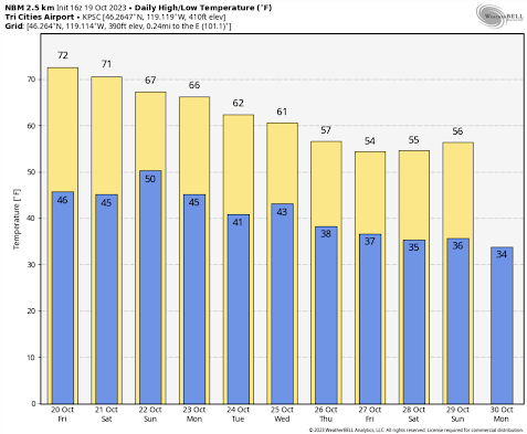
This cool-down is right on schedule. I have always been fascinated by the rapid fall transition in our region.
Let me show you the climatology for Seattle during the autumn (below). The red line shows the record daily high temperatures, and the blue shows the record lows. The average temperature range by the brown band. The vertical blue line is today.
Before today, high temperatures have reached highs of 80F or more, but not after this date. The intensity of the sun is getting weaker and clouds are increasing too much.
.png)
And another transition looms in one month--after mid-November serious cold-air outbreaks and snow can hit western Washington.
In short..time to get your sweaters out....
If memory serves, the last real El Nino winter we had in the PNW was around seven or eight years ago, and the temps rarely got below the high 40's/low 50's even at night. Although we did receive an ample amount of rain, enough to quell the expected fire season that summer. Does anyone have those stats to compare and contrast? I'd be curious.
ReplyDeleteLoving it. Next week Thurs and F ri noaa has snow levels my area, Okanogan Valley down to 2600 over night. Cliff how far out does your model go out? Seeing anything that may suggest models too warm. Also GFS shows snow our area Nov 1st, I know too far to trust but wondered what your seeing. Would love some snow.
ReplyDeleteThe effects of El Nino usually doesnt happen until after the first of the year, until than anything is possible before we bask in warm winter sun or rain. Im glad I'm not a skier bad news for those folks.
ReplyDeleteI am curious about the asymmetry in the annual temperature curve. According to climatology data I downloaded, the lowest normal high of 45 occurs on December 24 (the middle date of a string of dates with a normal high of 45) and the highest normal high of 77 occurs on August 2 (again, the middle date of a string of days with a normal high of 77). That means the normal high temperatures increase for 220 days and decrease for 145 days. Kind of weird, but consistent with the general feeling around here that it takes forever to warm up in the spring, while the transition from summer to autumn to winter passes quickly.
ReplyDeleteI've noticed this too, and it seems to be a West Coast phenomenon. In Connecticut, where I grew up, the temperature curve is more symmetrical (maximum in late July, minimum in late January). I mention this here once before.
DeleteI had to look up that super cold blip between November 11th and 18th. These record lows happened back in 1955, with the lowest being a crazy reading of 6 degrees on November 15th! The record lows for every day between November 11th and November 17th all occurred in 1955.
ReplyDeleteIt's been an early fall here near Mt Baker, cool and wet for a month. I don't know if we'll have "frost on the pumpkin" (or snow) on Halloween, but - just as for Budd - the NWSS forecast in this zone is for a freezing level of 3500 ft on Friday Oct 27, believable. My local annual "harbinger" is a mountain with a peak just two miles from my front door - Church Mtn. "First snow" was Sept 28, a month before last year's (on Oct 24). So - hey-ho. That's early. I do record overnight lows, and have for years - it was 35.6 here in the valley on 9/30. CoCoRaHS now has "data explorer" pages for precipitation records. I plunk daily lows and highs in the "notes" section of the "Obs Tables"- here's a link for my WA-WC-70 data. (I think these pages exist for all of the CoCoRaHS locations). I keep more detailed data elsewhere. But this new "dex" site is pretty interesting. URL: https://dex.cocorahs.org/stations/WA-WC-70/obs-tables
ReplyDeleteA study I did on minimum temperatures for the late fall through winter period at Spokane using their observations from 1881 to the present, showed that record or near record low temperatures in late October often occurred during El Nino or neutral patterns, but no mid-late winters (December thru February) had any long periods of significantly cold temperatures during El Nino patterns.
ReplyDeleteBeautiful perfect weather for the past several weeks, how lucky we all are! Cliff, i was out hiking in the alpine lakes wilderness on Friday at 7000 ft and around 3pm i realized i could smell the ocean! I thought i was imagining it but the air felt moist and definitely oceanic. I wondered if you could shed any light on what was happening?
ReplyDelete