The answer is possibly, depending on where you are.
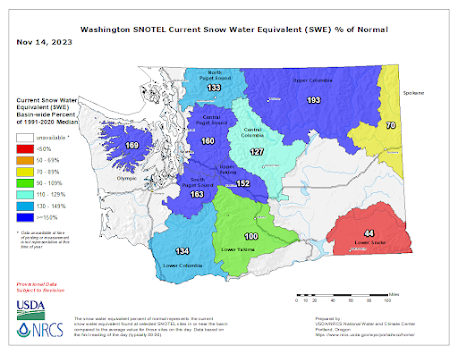
Let's start with a look at the status of the snowpack for Washington State from USDA Snotel (see below).
Most areas are above normal, with NE Washington at 193%. The cool, wet weather of the past week has really helped.
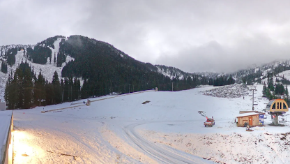
The NOAA snow analysis this morning shows the greatest depths in the north Cascades and southern BC. The Oregon Cascades have far less.Stevens Pass has about 8 inches on the ground with general coverage, but not nearly enough to open at this point.
The other Washington ski areas are in the same boat. But British Columbia's Whistler is in better shape and they are planning on opening on November 23. We will see.
So what is the snow forecast from the UW model? In the short term, it is not good. A significant ridge will build over the area for Thursday and Friday (500 hPa--around 18000 ft--shown below for Friday at 4 Am). This is a dry pattern for the region.
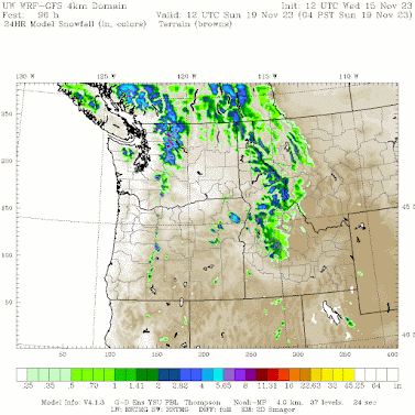
On Saturday, the ridge will break down and a trough of low pressure will bring some precipitation to the lowlands and snow to the mountains. The snow total from this event is shown below. Up to six inches in the north Cascades, but not enough for opening Stevens or Baker. A few inches for Whistler.


I am curious how a strong El Nino affects ski resorts located east of the Cascades, for example Mission Ridge near Wenatchee, or in Canada in the Monashee mountains.
ReplyDeleteOff to a slow start north of the boarder in the BC interior. Okaganan mountains have very little snow; especially compared to this time last year; Columbia / Rockies marginally better.
ReplyDeleteMost resorts are suppose to open over the next few weeks and looking at the forecast looks bone dry for the next 14 days based on Canadian forecasts and NOAA in what is typically the wettest time of year... continuing a below average precip Summer-Fall into what looks like a bellow average precip Winter. 2014-2015 anxiety building. If we don't see a turn around at the start of Dec then this could be a very bleak ski season.