One often thinks of eastern Washington as a place of sunshine and warmth. But during midwinter the opposite is true: the lower elevations of eastern Washington are often dark, cold, and covered by persistent low clouds.
Western Washington is often warmer and sunnier this time of the year.

Twin Bridges NW of Richland was in the murk
Consider the visible satellite imagery for the past two days (see below). Eastern Washington was engulfed by low clouds, while western Washington only had some scattered clouds aloft.
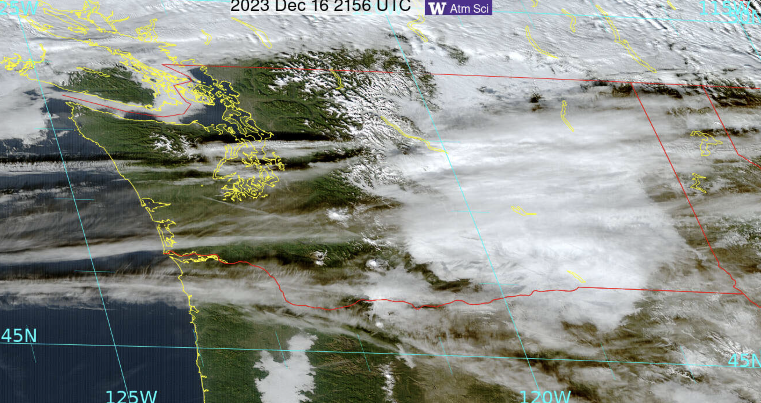


Solar radiation reaching the surface? A lot more over western Washington!
Looking at Seattle over the past week, four days had peaks in solar radiation exceeding 300 watts per square meter.

Those poor folks at Pasco only got that high (barely) on two days. Expert advice: don't go to the Tri-Cities to get a sun tan in December or January.

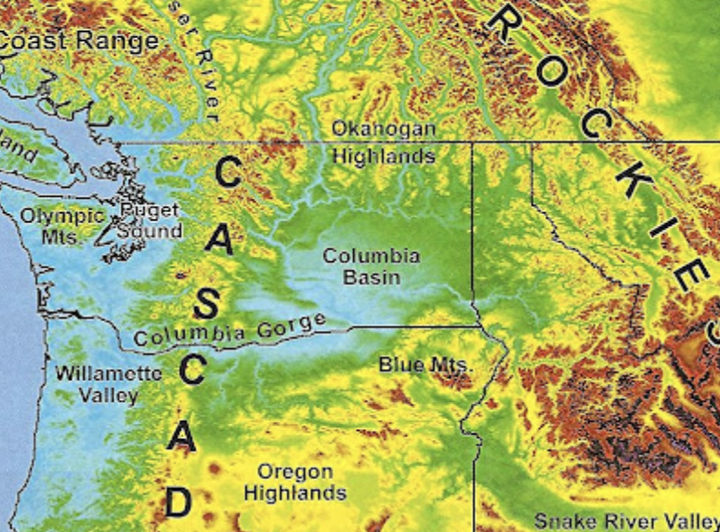
However, the Columbia Basin is world-class this time of the year for freezing rain, as rain from Pacific weather systems falls into the cold cloudy air trapped by the Columbia Basin during winter (see map).
So why is the Columbia Basin so cold and cloudy? Because it is a basin, ringed by higher terrain (see map below). The air cools on the surrounding terrain by infrared radiation to space. Cold air is more dense than warm air and thus sinks to lower elevations. Some cold air from BC can also "sneak" in through the Okanogan Valley on the northern side of the Basin.
Cold air at low levels in the Basin and warmer air above result in an inversion (temperature warming with elevation), which is a very stable feature that acts as a block to atmospheric mixing.
I can show you that such a temperature change with height occurred yesterday (Sunday) through the vertical sounding from a radiosonde, that was launched from Spokane, Washington.
Temperatures (right line) are below freezing (0°C, shown by the red line) in the lower atmosphere, capped by an inversion (blue arrow) of temperatures warming with height. The left line indicated the dew point. The temperature and dewpoint are nearly the same in the low-level cloudy/saturated air. Aloft the air is not saturated and thus are no clouds in that layer.

Unrelated to today's article! Do you have a preferred almanac source for average temperature and rainfall for a given city? I didn't find anything on NOAA and found surprisingly different results at https://www.timeanddate.com/weather/usa/olympia/climate and https://www.usclimatedata.com/climate/olympia/washington/united-states/uswa0318
ReplyDeleteThanks for your guidance!
https://www.weather.gov/wrh/climate?wfo=sew
DeleteTry this. Select either Olympia Area or Olympia Airport if it's official Olympia data you're looking for.
Lisa: You may find the new "Data Explorer" feature available at the CoCoRaHS map interesting. CoCoRaHS is a network of volunteer observers who report "rain, hail, (and) snow" - NOAA, NWS and other agencies do look to this information; observers all employ the same brand of physical gauge(s) and methodology.
DeleteAn "interactive" map of those observations is posted daily -- there's a very large number of locations, and the goal is that everyone should report 24-hr data within the same timeframe daily (some provide multi-day data). There's a nifty new feature.
Every "dot" (an observer's location) now has a "Data Explorer" link (bottom right hand corner of the pop-up). By clicking on that link, you can investigate the history of precipitation reported (both rain and snow), plus a variety of graphs based on observations over time. The real PLUS is that anyone can scroll-through the local observer's notes [look for "Obs Tables," right-hand side of the 'explorer' menu at the top]. Many - if not most - observers report details about daily highs and lows. Oh - the entire map can be re-set for past dates. There's a wealth of decent information out there! The CoCoRaHS site (just click on the map and zoom in) is at this URL
https://maps.cocorahs.org/ Enjoy!
Cliff, you might emphasize that snow does not (can not?) start with rain falling into a cold layer of air- instead this gives you super-cooled water which hits the ground and freezes. Snow, if I have got it right, necessarily forms in clouds by direct phase change of vapor to solid.
ReplyDeleteWell precipitation often rises and falls repeatedly without striking the ground. Given enough time aloft, per the Bergeron-Findeisen process can produce snow.
ReplyDeleteSo, Solar panels, whether on buildings or southern sloped open areas, do not provide any energy in the Columbia Plateau during winter months. Not needed during summer months. And therefore are detrimental to the environment and a drain of electrical resources overall.
ReplyDeleteStephani, I'm not sure, are you being sarcastic here? Or do you work for an oil or coal company? Because your post is not based in fact. Not every day of the winter is cloudy in Pasco. They get stretches of low clouds and fog during winter that can last a week or two at a time, just like the a good portion of the rest of Eastern Washington, but the Tri Cities gets approximately 300 days of sun per year. Even on a cloudy day, panels can still produce approximately 10 to 25 percent of their max output. And I'm not sure how you are coming up with the idea that the energy isn't needed in summer. You don't think people run air conditioners in summer in the hottest area in the state? The electricity provided is going back onto the grid and can be sent where it is needed, it's not a detriment to the environment, or drain on electrical resources. That doesn't even make sense.
ReplyDeleteThe Wenatchee Chamber of Commerce promised 300 days of sunshine and we are waiting after 16 years. It is indeed gloomy and a very monotonous brown landscape here starting the middle of December. Sunshine can be found on Mission Ridge
ReplyDeleteSTEPHANIE: I've been in Walla Walla in June when it was 114 degrees, and temps over 100 are common in Eastern Washington in summer. I bet the vast majority of people in the Columbia basin really, really enjoy running their A.C., which is a massive user of electricity, so "not needed during summer months?" Perhaps you should re-think your comment. Additionally, if I'm not mistaken, the Eastern Washington electrical grid has inter-ties with the entire west coast, so what isn't used in Eastern Washington, might get used in Phoenix, L.A. or Las Vegas.
ReplyDeleteHey cliff, what's the source of your solar radiation plots?
ReplyDeleteI attended WSU back in the 1970s. I can remember seeing the sun very seldom from November until March or April. And,when it came time to go home at Thanksgiving or the holidays, it was a very gloomy drive on highway 26 from Washtucna to Vantage.
ReplyDelete