This blog discusses current weather, weather prediction, climate issues, and current events
January 31, 2024
The Inner Secrets of An Impressive Pacific Storm
January 28, 2024
Water Vapor Fest over the Pacific Northwest
The U.S. West Coast is experiencing a very wet period and this pluvial bounty is not ending soon.
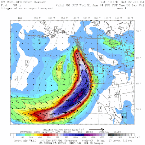
Dramatically, measures of water vapor approaching our coast are impressive.
To illustrate, consider the water vapor imagery from the NOAA GOES-West satellite on Saturday afternoon (see below).
I rarely show such imagery on this blog and it is virtually never presented by the media. Where it is white, there is a lot of water vapor in the mid to upper troposphere (roughly 18,000 to 35,000 ft). The image below shows the entire West Coast engulfed in H2O.
January 26, 2024
Water Resources Looks Good Over the Western U.S.
The end of January -midway into the western U.S. water season--is a good time to evaluate potential water resources for the upcoming summer.
There had been some concern that an El Nino winter would result in drought conditions for some and flooding for others. Fortunately, such fears do not appear to be realized.
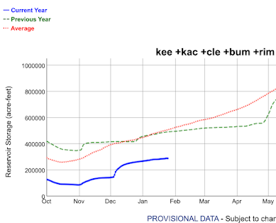
Let us begin by reviewing the all-important reservoir levels in California, whose low values two years ago were a cause of great concern.
As shown below, California's reservoir levels are in excellent shape and generally well above normal. The largest and most important reservoirs (Shasta and Oroville) are at 121 and 131% of normal, respectively. Other reservoirs are also in good shape.
Moving north, what about the water levels behind the all-important Grand Coulee Dam in Washington State? As shown below, water leves are above normal. Good for power generation and fish.
Seattle's reservoir levels?
In December they had fallen substantially below normal, but four days ago (Jan 22, shown below) were just below normal. Recent rains have brought reservoir levels up to nearly normal. With the certainty of substantial rains during the next weeks and a near-normal snowpack for the relevant mountain drainages, Seattle should be in good shape waterwise for this summer.
What about the current snowpack in the Northwest?Over Oregon (below), with the entire state averaging a bit over 100%.
Washington (below) is currently a bit below normal, with the critical Cascade watersheds around 80%-- a far better situation than a month ago. The Yakima drainage is at 91%.
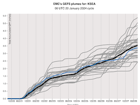
The next week should be very wet along the West Coast. First, the Pacific Northwest and British Columbia will be hit by a series of moderate atmospheric rivers (see the European Center total precipitation forecast through Monday afternoon below.)
Finally, with El Nino starting to weaken rapidly, its impacts should begin to fade during the upcoming months.
January 24, 2024
El Nino is Dying and the Northwest Will Get Drenched
All natural phenomena have their time and for our current strong El Nino, time is up.
January 22, 2024
One of the longest jet streams in memory
This week I gave a lecture to my junior weather analysis class on the jet stream, a current of strong winds in the upper troposphere (25,000 to 35,000 ft above sea level) in the midlatitudes. So I have been musing about this topic a bit.
Yesterday I saw the current map of winds at 300 hPa (about 30,000 ft) for the entire Northern Hemisphere and was taken aback: the longest continuous jet stream I can remember.
As shown by the map valid 1 PM Sunday, strong westerly winds exceeding 100 knots stretch from Iran to Baja, California. Halfway around the entire Northern Hemisphere. About 8000 miles.
January 20, 2024
The Cold Weather is Over
After a record-break string of cold weather, with ice and snow extending to many low-elevation areas in the Northwest, some very welcome warmth is coming.
In western Washington. you can say goodbye to the teens and twenties and welcome temperatures climbing into the 50s. Eastern Washington will thaw out.
And ample precipitation will return to the West Coast, helping to push off concerns about drought.
Winter is running out of time with ice/snow conditions over the lowlands becoming far less possible in roughly a month.
Strangely enough, if one averages over time, this winter has not been unusual, a fact that probably will not gain the interest of the media. Looking at the temperatures at SeaTac (blue lines) versus the normal range (brown band), we were cooler than normal in November, warmer than normal in December, and uber-bold in January.
Preciptiation? Amazingly the total since October 1 (known as the water year) has been nearly exactly normal. No drought.
Eastern Washington has a similar story, as shown by the precipitation in the Tri-Cities.
And now the part that will warm your heart and other body parts.
The predicted temperatures in Seattle for the next 12 days is for warmer than normal conditions, with many days getting into fifties. You won't even see thirties.
The Tri-Cities into the mid-40s by the end of the period.
The UW model's cumulative precipitation forecast for the next ten days will bring a smile to local ducks and slugs, with substantial precipitation (reaching totals of 10 inches in the mountains), from central California to British Columbia.
January 18, 2024
Freezing Rain or Rain That Freezes? They are NOT the Same!
On Tuesday there was a lot of talk about freezing rain events, ice storms, and the like. There was also a lot of confusion and misinformation about what happened Tuesday evening as precipitation moved in.
As I will describe, there was a lot of above-freezing rain falling on cold surfaces, but very little freezing rain. Few locations experienced freezing rain, but some locations had rain that froze on localized cold surfaces.
The Wiki definition is pretty much the same:
By 10 PM, the precipitation band was over Puget Sound (and would be through by about 1 AM)--see below. Temperatures were still above freezing through much of the lower atmosphere, except for a narrow layer where evaporation of falling rain cooled the air to near freezing. The surface air temperature at SeaTac at 10 PM was 31F.
However, such a shallow layer of near-freezing air did not warm the rain by much and it hit the ground above freezing (I measured the temperature of the rain at my house that night and it was roughly 35F).
January 16, 2024
Heavy Lowland Snow over Northwest Washington Tomorrow
Snow is coming back to the Washington lowlands.
Northwest Washington, from Bellingham to the San Juan Islands to the northern Olympic Peninsula, will experience a significant snowfall.
The Puget Sound lowlands will experience some flakes, and maybe even some limited freezing rain, but it won't amount to much.
I waited to talk about this until I had confidence in the forecast.
Let me start by showing you the total snowfall (amount of snow falling from the sky) from the latest high-resolution UW forecast. Snow depth would be less.
The precipitation will reach us around dinner time today, but temperatures will be too warm for snow over most of the lowlands. Here are the predicted snow totals through 10 PM tonight. Light amounts over the Olympics and the southern Cascades.
The MUCH lower-resolution European Center model is similar, so there is some confidence in this prediction (see below).
.gif)


