February 28, 2024

Unusual Early March Lowland Snow

In normal years, we would be coming to the end of the lowland snow season.  

Yes, there has been snow during the first weeks of March in the past, but it doesn't happen often and when it does the snowflake accumulation is light.

Consider the historical snowfall totals for March 1-15 at SeaTac Airport over the past 50 years (below).


Most years get nothing, but a few have experienced several inches.

The latest forecasts suggest that the mountains will get hit hard by snow and that significant portions of the lowlands, particularly away from the water, will be whitened.

Today, after the warm front passage last night, was too warm for lowland snow, with highs getting into the upper 40s around the western lowlands.

But don't get too comfortable: a very strong cold front is now moving inland and temperatures and snow levels will plummet.

I knew we were in for a profound cool-down when I saw the visible satellite image this afternoon:   the 4 PM image is shown below. 

You could see the nearly uniform frontal cloud band with highly unstable showers precipitation offshore (the white and black mottled area).  That is our future.


Importantly, a beast of a cold front was found at low levels under the clouds.       This intense cold front, indicated by a narrow cold-frontal rainband, was evident in the radar image at 6:35 PM from the Langley Hill radar near Hoquiam (the arrow points to the front and rainband)


The frontal passage this evening will foretell an unusually snowy future for many of you!

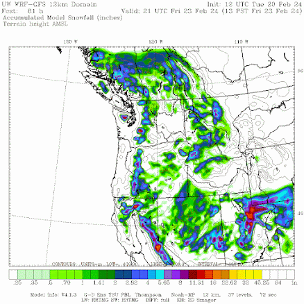
The latest UW WRF forecast run has just arrived and is shown below.

The prediction for accumulated snow for the next 24 hours (through 4 PM Thursday) shows substantial snow over the mountains, including the lower slopes.  But little over the lowlands.


But the next 24 (through 4 PM Friday) forecast map shows non-trivial lowland snow away from the water.  Temperatures are on the edge of rain/snow but the models are going 1-2 inches away from the water.


But the lowland snow fun is not over, with the next 24-h (through 4 PM Saturday) bringing more lowland snow, particularly along the coast and around Portland and Northwest Washington.


I know....you want to get an idea of the uncertainty of this forecast.  No problem.

Below are the predictions of accumulating snowfall total at SeaTac from the UW high-resolution ensemble system in which many forecasts are made...each slightly different.     \

A lot of spread in the solutions (the black is the average of them all).  Virtually all are going for snow, with total snowfall ranging from 0.5 to 3 inches.  So there is some uncertainty....better you are aware of it.


Finally, the uber-skillful European Center model is also going for substantial lowland snow, but in different areas (see the total through 7 PM Saturday.


You can bet that a lot of lawns and roofs will be white before this is over.  And the accumulation of snow in the mountains will continue.


February 26, 2024

The Snow has Arrived and Much More is on the Way

This afternoon I biked home in light snow and it was magical.   And the Northwest will enjoy a lot of snowflake magic during the next week.

Tonight (Monday) it is cold enough to snow with any significant precipitation intensity.

The latest radar shows two precipitation snowbands from two convergence zones:  one downstream of the Olympics and the other downwind of the mountains of Vancouver Island (see below).  Snow is being observed in both.


The latest NOAA HRRR model forecast predicts more snow in these two bands (see the one-hour snowfall ending at midnight below).  Perhaps an inch in favored areas.   But nothing that will really cause much of a  problem in the western lowlands.

But the big action is still ahead...not for the lowlands, but for the mountains.  Very heavy snowfalls.   And then another chance for lowland snow on Sunday.

Tomorrow afternoon a vigorous Pacific warm front will move across our coast, bringing strong, moist southwesterly winds that will push up local terrain.  The map at around 5000 ft (850 hPa pressure) on Wednesday morning at 4 AM illustrates the situation.  Very strong winds from the southwest at that level.  This is a very wet pattern


No more snow at low elevations, but feet of snow will fall in the mountains.  The accumulated snow total through 1 AM Thursday is shown below.  3 feet in some places


Later this week, a supercold upper-level trough will settle over our offshore waters, leaving western Washington and Oregon quite cold, with rain and snow showers even near sea level.  Northern California gets hit hard with rain and snow.

All and all, very good news for West Coast water supplies and regional skiing.


February 24, 2024

Heavy Snow in the Mountains and Snowflakes over the Western Lowlands are Now a Certainty

We are now close enough in time to predict a snowy future:   many feet in the mountains and a good dusting in several western Washington locations near sea level.

Some dramatic changes in our weather are ahead starting tomorrow (Sunday) afternoon.

During the afternoon, a very strong cold front will move through western Washington, bringing powerful winds and rapidly declining temperatures. 

To illustrate, below is the predicted surface weather map for 1 PM Sunday, with pressure (isobars, solid lines),  surface winds, and near-surface (800 meters) temperatures (shading) shown.

I have indicated the frontal location on the map (red line), with cold air (blue color) behind it.  


Do you see the large change in pressure over western Washington (lots of lines)?   That will cause strong southerly winds, with gusts to 30-45 mph over the lowlands. 

After the front moves through, it will be game-on for regional snow.

Snowfall accumulations from 4 PM Saturday through 1 PM Sunday, right before the cold front moves into western Washington, is moderate, with perhaps a half-foot over the northern Cascades.


One day later, as cool, moist Pacific air from behind the cold front has pushed through, and the mountain snowfall is getting impressive, with higher elevations getting 2 feet or more.  Look carefully and you will see some snow reaching sea level, particularly north of Everett.


More snow will fall on Monday night and Tuesday morning, bringing mountain snowfall totals of 1-2 yards by Tuesday Afternoon.

The European Center model forecast is similar, and if anything more generous with the snowy bounty, with the totals through 4 PM 3 March pretty impressive.  much of the Cascades receiving more than 45 inches.


The NOAA Climate Prediction Center is going with the chilly, snow-laden message with its prediction for search March being much colder and wetter than normal in the West (see below).


And did I mention that El Nino is starting to collapse?

A lot of reasons to expect our water situation and snowpack may not be too bad starting summer.

February 22, 2024

How unusual is it for aircraft to exceed the speed of sound?

Announcement:  Doing an online zoom session with Patreon supporters at 10 AM tomorrow (Saturday)

______________________________________

The media this week was full of stories talking about aircraft going faster than the speed of sound.

Freak, supersonic wind speeds, some exceeding 800 miles per hour.


For reference, the speed of sound around cruise level (roughly 35,000 ft) is around 664 mph.  Some eastbound, north Atlantic flights arrived 30 to 45 minutes early, one over an hour early!

So what happened this week over the North Atlantic and how unusual was it?  All will be revealed here.

First, a bit about planes going "supersonic".   To be truly supersonic, the aircraft has to move faster than the speed of sound (roughly 664 mph a cruise altitude) relative to the air.   

They never do.  

When the media talks about "supersonic" they are talking about the speed with respect to the ground, which is NOT the same thing.  Aircraft can go very fast relative to the ground if the aircraft has a large tailwind.....as was experienced earlier this week.


Since the average jet aircraft flies around 560 mph at altitude, a tailwind of over 110 mph would result in it moving faster than the speed of sound relative to the surface.  

The winds aloft were truly screaming along the U.S. East Coast on Sunday and Monday of this week.  Here is a short-term forecast of the winds at a pressure of 200 hPa (about 38,000 ft) for Sunday morning.  Wow.   

Over the mid-Atlantic states and offshore, some winds were forecast to reach 215 knots (247 mph).  That is cranking.  And since these winds were from the west, aircraft heading to Europe were going over 800 mph to the east.


So how unusual were the winds, say over Washington, DC during this event?    

There is a radiosonde (balloon-launched weather station) at Sterling, Virginia (Dulles Airport), just to the west of Washington, DC.     On Sunday morning, the ballow measured a speed of  218 knots from the west.

Impressive.  But how unusual?  Below is a plot  (red line) of the daily 250-hPa (about 33,000 ft) strongest winds at that location for a period from 1950 to today.  The star indicates the Dulles winds on Sunday.  

That morning, there were the second strongest winds at that level in over 70 years! That is very, very impressive.

Monday evening the strong winds moved offshore, still giving European-bound aircraft a mighty boost eastward (see wind speeds below)


Although these winds were exceptional over Dulles and clearly stronger than normal, they are not as exceptional when considered on a hemispheric or global scale.

To illustrate, below is a plot of the winds aloft (250 hPa level, about 33,000 ft) at the same time for the entire hemisphere.  Several strong-wind hot spots are evident, with several showing winds exceeding 160 mph.


A forecast of the winds for next Wednesday at the same level shows very strong winds over the SE US, with plenty of "supersonic" potential around the world.


The southeast U.S. has done very well for strong winds during this period,  but typically the strongest jet stream is found over southern Japan and out into the Pacific.  

The strongest jet stream ever observed by a radiosonde?  259 mph near Yanongo Japan in 2004.


February 20, 2024

Substantial Snow Returning to the Pacific Northwest

During even the strongest El Nino years there is often a period at the tail end of winter when the atmospheric circulation associated with El Nino collapses.

When the atmosphere adjusts to considerably more solar radiation over the northern latitudes the "lock" of the tropical Pacific is lost.

This re-adjustment will likely occur next week, leaving the door open to cool wet flow over our region.

This means lots of mountain snow and even the chance of flakes near sea level.

Let me show you!

The forecast for total snowfall through 1 PM Friday is hardly impressive, with a few inches in the mountains.  Yawn.


By 1 PM Sunday, the totals in the north Cascades and southern BC are healthier, reaching nearly a foot in favored locations.


Fast forward to 1 PM Tuesday, and the Washington Cascades and Olympics have gained several feet.  Considerable lowland snow is evident.


And by 10 PM Wednesday, February 29th. some mountain areas have gained 4 feet and parts of the western Washington lowlands have a thin veneer of snow.


So what is going on? 

 Examining the situation at around 18,000 ft (500 hPa) this morning, a strong trough of low pressure is found off the California coast. This is the kind of pattern that has been dominant over the last few months.


Fast forward to the end of the week (Sunday evening) and a very strong trough of low pressure is moving in.   Classic snow producer for the NW.


But the shocker is the prediction for March 1 (below).  Very cold, powerful trough off our coast.  Very wet, very cold, and very snowy.


All of this is a bit far out in time to be sure, but most of the solutions of ensemble forecast systems, in which the model is run many times with slight changes, produces similar predictions.  You may not want to put away your winter gear quite yet.

Keep tuned.


February 18, 2024

Dry Air Storm Hits Western Washington

 How do I put this tactfully?

Have any of you noticed any dry or cracking skin?

Or perhaps a parched mouth at night, requiring a sip of water?

I have and I know exactly why it is happening:

Desiccating, easterly downslope flow moving from eastern Washington into the coastal regions has occurred repeatedly during the past week.

A dry storm if you will.  The Northwest version of the Sahara.

Consider the outdoor relative humidity at Seattle Tacoma Airport during the past week.  Under 50% for nearly a day--dropping as low as 30%!  A day before it got down to similar levels.

Portland (below) was even worse,  with additional low-humidity episodes earlier in the week. There is a reason Portland is so bad...and it has to do with the Columbia Gorge (more later).

But these are just point values, let me now show you the lowest relative humidities that occurred in Washington and British Columbia on Friday (below).  

Amazing.  A large portion of northwest Washington and British Columbia had relative humidities dropping into the 20s!      No wonder skin my need some ointment!


As you might expect, the uber-skillful UW WRF modeling system predicted the dry storm well in advance, as shown by the relative humidity prediction for 10 PM Thursday (below)


So why such dry air?

The map below shows sea level pressure, near-surface winds, and lower-atmosphere temperatures at around 2500 ft ASL(color shading, blue and purple are cold) at 7 AM last Friday morning.  Cold, dense air to the east produced high pressure, while a Pacific low-pressure center was offshore.  There was an intense pressure difference over the Cascades due to cold air banking up on the eastern slopes of the barrier.


Over terrain, air near the surface tends to move nearly directly from high to low pressure, and thus the pressure difference forces strong easterly (from the east) winds.    Some of the winds moved directly over the mountains, while in places with gaps (like the Fraser River Valley and Columbia Gorge), cold air moved westward within sea level in the gaps.
 
The cold air has low amounts of moisture since cold air holds far less moisture than warm air.  As that air from eastern Washington crossed the Cascades and then descended the western slopes of the barrier, the air was warmed by compression, which caused the relative humidity to plummet.

Why? 

 Because relative humidity is the ratio of the amount of water vapor in a sample of air divided by the maximum amount it can hold.   Warm air can hold more water vapor than cold air.  Thus,  relative humidity plummets for warming, sinking air.


The effects of downslope flow is the reason why the lowest relative humidities were downstream (west) of the terrain crest in the figure above.

The future outlook for relative humidity?   Good news....no more dry storms on the horizon.


February 16, 2024

California Enjoys the Northwest's Water

 Two years ago, media outlets were headlining strident messages that California had moved into a "megadrought" and that there was little hope for relief.

Story after story claimed that global warming had permanently changed the situation and that California's reservoirs would remain unfilled.


Fast forward two years and these apocalyptic warnings appear more like a rendition of chicken-little than reliable climate science.

Massive rainfall has hit the Golden State, while we in the Northwest are enjoying a warmer-than-normal winter with less snowpack than normal.

Below is the percent of average precipitation for the last month over the western U.S.  Some parts of California have received over 400% of normal!


To illustrate the soggy California situation, below is the accumulated precipitation at Los Angeles since October 1 (the current water year). Brown indicates normal values.   LA is now running about 40% above normal


Compare this to Seattle (below).  We are slightly above normal.   Precipitation-wise we running nearly exactly on climatology.   That may surprise some.


As I have described in several previous blogs, we are now experiencing El Nino conditions, which tend to make California very wet, while our area generally experiences near-normal precipitation.   

The latest forecast of accumulated precipitation through Tuesday shows a continuation of the pattern with heavy precipitation expected in California.  And yes....only modest precipitation over Washington.  Oregon enjoys a piece of this wet bounty.


The origin of this wet situation is a strong El Nino low center off of Califonia, illustrated by the upper level (500-hPa pressure, about 18,000 ft) at 10 PM on Monday.  The purple shading indicates an unusually strong low.  I am getting tired of this pattern.


The current extended prediction of accumulated precipitation through April 1 by the European Center model suggests this pattern is not going away, with very wet conditions over California, but drier than normal in the Washington Cascades (see below).


But what about the Northwest snowpack during the next few months?    I will leave that to an upcoming blog.


February 13, 2024

Some Lowland Snow is Coming Western Washington Late Wednesday and Thursday

Historically,  the window for lowland snow over western Washington closes the last week of February.

It appears that we are going to get some flakes before it is too late..... but not that many.


Let me start by showing you the latest forecast by the UW WRF prediction system.    Below is the forecast sea level pressure and low-level temperature map for 10 PM tomorrow (Wednesday) night.  

Cold air (blue color) is found in British Columbia, Alberta, and Montana.  Some pushes into eastern Washington.

A low-pressure center moves on to the northern Oregon coast, drawing cool air into western Washington.  The trouble for western Washington snow is that the low is a bit too far south and temperatures are marginal.  This pattern would push cool northeasterly flow through the Fraser River Valley into Whatcom County and the San Juans.


The latest UW high-resolution forecast for snow accumulation through 1 PM Thursday,  shows some lowland snow from roughly Olympia to Chehalis, and plenty over the south Cascades.  The southeast side of the Olympics gets a few flakes as well.

The Columbia Basin gets some light snow.


Nothing exciting perhaps, but snowflakes are always of interest.   There is, of course, some uncertainty in the forecast, and the way to get at that is to examine an ensemble of many forecasts.

The City of Seattle SNOWWATCH website shows the ensemble forecasts for Seattle (see below).  The gray lines are individual forecasts, and the ensemble average is in black.  Many forecasts are going zero, but the average is about .5 inches and snow depth would be much less than that.  Perhaps a dusting.  Quite possibly nothing.


In short, I would not be getting the sled out, but you might spot a few flakes.