Over the lowlands of Washington State, today was sunny and generally clear. Not a drop fell out of the sky.
But something very different happened in the mountains, where the atmosphere became unstable, resulting in cumulus clouds and showers. Even some lightning!
Let me show you and explain.
To begin, here are two visible satellite images: one at 6:30 AM and the other at 5:30 PM today.
The morning image had little clouds with snow visible at higher elevations
The lowlands are still clear, but many clouds are over the mountains. Cumulus clouds, including some tall cumulonimbus.
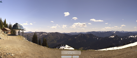
You can see the changes from ground level from the wonderful Crystal Mountain cam.
At 6:20 AM it was clear looking to the east.By 1:20 PM, the clouds had become more widespread and deeper.
The 6:10 PM shot shows deep cumulus that were precipitating. You can see the rain under the cloud base (called virga).
In fact, there was measurable precipitation at several mountain and downstream sites during the past 12-h (see plot below).
So why cumulus clouds and precipitation in the mountains (also known as convection) and not over the lowlands?
Cumulus clouds are associated with atmospheric instability, in which the atmosphere convects with up and down motions, not unlike what occurs in your hot cereal saucepan or in a lava lamp (see below).
Convection breaks out when the temperature decrease with height gets sufficiently large. Normally this is due to heating near the surface but it also can occur when there is cooling aloft.
Mountains act like high-elevation heat sources, particularly after the high-elevation snowpack has melted. That results in a larger temperature change with height above the mountains than over the lowlands. The air over the mountains becomes unstable, leading to cumulus clouds (see schematic below).
This effect is largest in the afternoon when solar heating is the greatest.
But wait! There's more! During the day, there is upward motion on the heated slopes of terrain, resulting in strongly enhanced upward motion over the mountain tops. Upward motion contributes to cloud formation and the development of instability over the mountain crest.


I dunno how much the radar's picking-up this afternoon (Thursday, June 20), but I'm seeing plenty of cumulus east of Glacier. This doesn't surprise me a bit; it makes me think of observations I've heard from pilots and seamen about 'island effect". I can't guess if there's any precipitation, but these have a decidedly "thunderhead" look to them.
ReplyDelete