It is a phrase that puts fear into the hearts of all true Northwesterners: June Gloom.
You thought we escaped it? Think again.
But first, we have an even warmer day than today in store for Saturday, with Puget Sound Country hitting 80F and another ten degrees over the Columbia Basin.
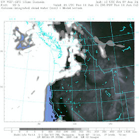
During June Gloom periods the northeastern Pacific fills with low clouds, which push into western Washington and Oregon (see below). In fact, the whole West Coast can suffer from this affliction.
The cloud coverage this morning shows why today was so warm:
But Sunday morning is a different (and cloudier) story.


The last week of May and first week of June definitely qualified as the ultimate June Gloom. As in REALLY bad. But I'm just not seeing that in the forecast, at least according to Accuweather (for both Seattle and Bellingham). Cool yes, patchy clouds, yes, but actual gloom? Not so much. Spring-like, I would say -- but I'd curious to know if those satellite images are showing some rain-shadowing (cloud-shadowing?) and is that the morning cloud cover we're looking at?
ReplyDeleteThanks for the clarification. I'm still not sure why that would strike fear in the hearts of true Northwesterners.
DeleteFair enough. It doesn't help that we have real time updates on what's going on in the rest of the West (heat dome etc.). It's like we're on a strange island here.
Deletethe more clouds, the more better! i'm here for it!
ReplyDelete