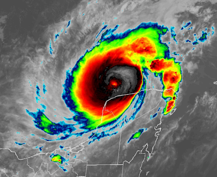
What happened to Hurricane Milton yesterday is truly stunning.
Over one day, the strongest sustained winds in the storm strengthened from 90 to 180 mph. It has subsequently weakened to "only" 165 mph. Still a very strong category 5 storm.
The central pressure of the storm declined to 897 hPa (a unit of pressure) before increasing to 914 hPa.
The strongest Atlantic hurricane on record (Wilma) had a central pressure of 882 hPa..... not that different than Milton!
Milton revved up over a patch of warm water northwest of the Yucatan Peninsula. We are talking about water in the upper 80s (F). Fortunately, it is now moving over cooler water, which is contributing to a modest weakening.
Now let me show you some amazing simulations.of 10-15 ft (see National Hurricane Center map below). It is clear that the west coast of Florida from Tampa southward needs to be evacuated immediately.
_____________________________
Announcement: Free Public Lecture at Kane Hall on October 10: Global Warming, the Jet Stream, and Cold Waves
All of you are invited to attend what should be an excellent public lecture by Professor Jonathan Martin on how global warming affects the jet stream and cold air outbreaks.
It will be a timely and interesting lecture accessible to non-meteorologists and given in honor of UW Professor Peter Hobbs.
The talk will be at 7 PM in Kane Hall room 210.
If you would like to go, please register online here:
Parking is available (at a modest cost) in the UW Central Garage, which is located directly under Kane Hall. Or take the light rail (the UW stops are a 5-10-minute walk away).


Scary stuff. I hope those living along the forecast track don't ignore the warnings to leave. They have plenty of time as it stands if people act NOW.
ReplyDelete[Also, Cliff: your reference about the recorded pressure of Allen reads '989' when I think you meant '889'.]
Dr. Mass: as the warm temperature of the Gulf feeds these storms, do they take an appreciable amount of heat out of the Gulf and lower its temperature? I understand it might not be much, and continued global warming will soon raise the temperature back…thank you for your time.
ReplyDeleteSee my answer below. Hurricanes cause surface cooling by mixing....but that is restored quickly. Global warming has nothing to do with it.
DeleteDid Helene pull enough heat out of the eastern Gulf to account for the cooler water and (hopefully) a reduction in intensity?
ReplyDeleteThe heat content of the upper ocean is generally refreshed quickly....1-2 weeks at most.
DeleteIs the mass of clouds to the NE of the eye still part of the hurricane?
ReplyDeletehttps://cdn.star.nesdis.noaa.gov/GOES16/ABI/CONUS/GEOCOLOR/1250x750.jpg
Worth noting....just before it landed by Sarasota, all the gauges (that i could see...buoys and an airport or 2) had sustained winds only around 70mph-80mph. How long after a storm does NOAA wait before updating the official wind totals?
ReplyDelete