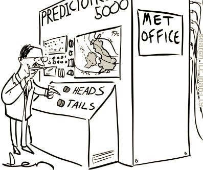
The next time someone makes a weatherperson joke, remember the nearly perfect forecast for yesterday's wind event over Washington.
No longer appropriate
For days, the models correctly predicted the rapid development of the cyclone offshore and the high pressure inland. The combination resulted in strong easterly winds that descended the western slopes of the Washington Cascades.
You want to see how perfect the forecasts were? Here is the wind speed forecasts provided to Seattle City Light from the UW's WindWatch website, which uses the best of the regional weather prediction models.
This graph shows the highest observed wind over Seattle (black line) and the forecasts made starting Monday afternoon.
You don't get much better than that. Earlier predictions were just as good.
A lot of attention was given to the strong cyclone/low-pressure system that developed offshore. It was an impressive low that not only rapidly developed, but deepened to 943-943 hPa, slightly beating or equalling the historical record.
Weather prediction technology has improved immensely in skill and detail.
The above results are not a fluke.... I could show you a dozen more, including the predictions of devasting extreme events, such as the Lahaina wildfires or heavy precipitation from Hurricane Helene.
There is so much talk about extreme events and global warming.
But the truth is that deaths and injuries from extreme events are declining rapidly because weather predictions are so good. Such deaths and injuries could be greatly reduced further if governments and other institutions would better use highly skillful weather prediction.
The Upcoming Storm
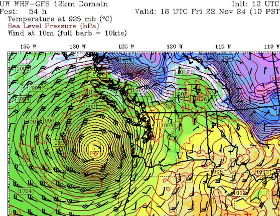
Another midlatitude cyclone will be moving up the coast on Friday.
On Friday morning at 10 AM, a 977 hPa low will be directly east of the Columbia River outlet. Much weaker than yesterday's storm, but much closer.
Compared to Wednesday, this storm will produce strong winds on the coast, but weaker winds over the western WA interior.
For example, at 1 PM Friday (below_, fearsome winds on the coast, but "only" gusts to around 25 kt (roughly 30 mph) in the interior.


Very impressive skill with the models and forecast. It played out as if it were scripted, here in North Bend anyway.
ReplyDeleteIf the models were so good, why did the NWS forecast for Seatac only have gusts to 33? Thats what it said all day 11-19 and even in the evening when Seattle was getting hammered with 55+mph winds
ReplyDeleteWondering how many electric and natural gas customers who voted against retaining natural gas as an option are now getting cold.
ReplyDeleteMy natural gas heating system still needs electricity to run.
DeleteNothing about that measure prevented the continued use of gas. It was about encouraging movement away from gas but access to gas was never going to be denied. This is a misperception.
DeleteThe original bill banned new gas hookups and removed PSE's requirement to serve gas to customers within its service area. The intent was clearly to squeeze Puget Sound homeowners to make the $40,000 conversion to all-electric on their own dime. Was that what passed the Legislature last session? No. Was it the next thing on their list if the people hadn't put their foot down? You bet.
DeleteYes, my natural gas furnace needs electricity to run, but fortunately my natural gas powered generator provides that electricity to keep my house warm and lighted for going on 48 hours now. I understand that a shift from fossil fuels is underway and maybe necessary, but this storm makes it obvious that the power grid is not yet robust enough to do away with natural gas completely.
DeleteDid y'all notice how modest Cliff is being? Go back to Oct. 5th and check out his blog then. Title: "Improved Chances for a Big Northwest Windstorm This Winter." That prediction sure didn't take long to verify!!
ReplyDeleteI'm also glad he pointed out how well forecast models predicted this complex, unusual event, plus how accurately the data was interpreted.
Thanks for the insight!
ReplyDeleteA big part of what made this forecast impressive to me was looking at the forecast maps Monday afternoon showing the sub-950 mbar low expected to form off the coast...
ReplyDelete...comparing it to the satellite images showing nothing remotely resembling (to my untrained eyes, at least) a major cyclone brewing...
...and then less than 24 hours later, seeing the satellite images showing the storm pretty much right where the models said it would be.
The magicians who run the models said atmosphere was going to pull a rabbit out of its hat. I looked at the hat / satellite images and saw that it was empty. And then the atmosphere actually did pull a rabbit out.
Extremely impressive, and it's awesome how improved weather forecasting is able to save lives.
ReplyDeleteWorldwide, climate change causes hundreds of thousands of extra deaths every year, and the number is rising, not falling. “Extreme events” account for only a tiny fraction of that. Most of it is from drought, crop failures, displacement, and disease.
On Cliff's FB yesterday I expressed concern that Environment Canada's forecast might be gravely underestimating wind gusts for the Saanich Peninsula north of Victoria, with the HRRR and WRF-GFS expecting 45-50 knot gusts around Victoria Int'l Airport (YYJ). But YYJ's highest gust in hourly reports was 37 knots, and the highest for the day was 41 knots. The Saanich Peninsula was much less messed up or blacked out than many surrounding areas. The Canadian GEM, despite allegations of being inferior to some other models, still seems to be earning its keep.
ReplyDeleteSo how come where I live in Brier, there was not really any wind at all? Our power never went out, and there's almost nothing down in our yard. Didn't even blow the lid off of our trash can, much less knock it over. I don't think there are any reporting stations here, but I seriously doubt we had any gusts above 25MPH. Is there something about the track of this low that would account for that?
ReplyDeleteThere are several reporting stations in Brier on Weather Underground.
DeleteIt may be that you are like Gig Harbor, are in a wind shadow whereby the winds bypass your area. I have a sister in Gig Harbor, and no wind at their house.
DeleteI live in Tacoma, no power loss, but did have the lights flicker periodically all evening until I went to bed before 10PM. Never lost power all night.
Another sister on Bainbridge Island did lose power just after they sat down to dinner and it did not come back on until 8AM yesterday.
Most people are very simple minded creatures. The way it works is, if you get it right 99 times and wrong 1 time, you will only be known for the 1 wrong time.
ReplyDeleteThe only thing that was off, imo, was that the cyclone was much further off course than predicted, more than 50
ReplyDeleteMiles out — so what would have changed if it was closer but the same power… likely models would have been off. Just thinking.
Thanks Professor. Much appreciated.
ReplyDeleteI love exciting weather but this bomb was a total "dud" here in Tacoma. No real storm was had here, wondering why we missed all the excitement....
ReplyDeleteBe grateful you "missed it." A couple of dear friends of mine lost their wife/sister when a tree fell on their house.
DeleteIm about to travel down the 5 for 2 days worth of driving (starting tomorrow) so this is all very helpful. This blog has been my lifeline to accurate information about the weather.
ReplyDeleteWhat does this mean for power? Will we experience additional outages, damage, etc?
ReplyDeleteExcellent forecast, Cliff. Here on a ridgetop in Shoreline, we had one 75 mph gust at 8:05 pm that peeled paint off the house and crashed large fir branches down all around us, but mostly it was a steady 25 with occasional gusts to 40-50. I feel thankful that the hurricane force gust was a single event, rather than one of a handful. We escaped relatively unscathed despite our topography being more exposed than many of our neighbors.
ReplyDeleteWell done! The forecast helped; much appreciated.
ReplyDeleteLiving in Sammamish this second wave of wind has me stressed again. Hopefully the gusts are not major.
ReplyDeleteWe are in Mirrormont on Tiger Mountain and we were devastated by the storm. The air is thick with the smell of 2-cyl gas fumes from all the chainsaws. Another storm is not what we need.
DeleteVery accurate! I would love to know why the Greenlake, Wallingford and Ballard area had relatively light winds and little damage from the storm. I assume a quirk of geography - or in the case of Ballard fewer large trees?
ReplyDeleteMost all of Seattle has far fewer big trees than the outer areas, hence damage tends to be much lighter in the city.
DeleteBallard and Wallingford in particular are low-lying. People who live at 150 ft wondered what the fuss was all about, while their neighbors at 400 ft with tall trees dealt with tropical storm force winds for hours.
DeleteSome readers have asked about how this storm compared to the Columbus Day storm of 1962 and other more recent ones. Perhaps Cliff will write a blog about this. I had personal experience with the Columbus Day storm, having been one of the forecasters on duty at Portland that day. There is mention of how quickly this recent storm developed, termed a meteorological bomb, with a pressure fall at one location of 27 millibars in a six hour period.
ReplyDeleteAs the Columbus Day storm was intensifying, a stationary radar picket ship west of northern California recorded a drop of 22.5 millibars in 3 hours. The CD storm center moved northward just offshore much closer to the coast than this current storm. You may notice from the surface weather maps of this recent storm in Cliff's blog, two areas of very tightly packed isobars, one along the west slopes of the Cascades where the strong east winds occurred and the other out around the center of the low offshore, with even a tighter packing of isobars there. Strongest winds are usually where the isobars are most tightly packed. During the Columbus Day storm, it was that area just south of the low center that moved over western Oregon and Washington producing very strong south to southwest winds, with many inland areas reaching 75 to 100mph. We were fortunate that the center of this recent storm stayed far offshore or we could have seen winds similar to Columbus Day.
This is excellent perspective that most of us lack. Thank you.
DeleteWell done on your forecast Cliff! Those mountain wave winds were so impressive, here a few miles north east of Arlington it was so loud in the hills to the north, constant trees breaking then about every 5 to 10 minutes these huge rolling gusts seemed to just drop down on our area, I now have much more respect for what a wave windstorm can do
ReplyDeleteThat's very reassuring that weather forecasting has become so accurate! Since I live right by the coast, I was wondering if a tsunami could be a predicted ahead of time?
ReplyDelete