The Olympic Mountains are a meteorological laboratory par excellence. As shown below, the Olympics are nearly ideal as a meteorological research zone: an isolated, near-circular barrier approached by uninterrupted flow from off the Pacific. Plus, lots of observations around and within the barrier.
Consider this week. Strong moist flow approached the barrier from the south, producing a stunning contrast in precipitation. Consider the total precipitation from Sunday to today (Thursday) at 6 PM (below).
Extraordinary. 10-12.5 inches over the southeast slopes of the barrier near Lake Cushman, but less than an inch from Sequim to Port Townsend. Only 0.28 inches on northern Whidbey Island.
The Skokomish River is found on the wet southeast side of the Olympics and according to the National Weather Service, it reached flood stage.
But there is more! Strong downslope winds produced powerful warming and drying on the northeast side of the barrier that was captured by several weather stations on the lee slopes of the Olympics.
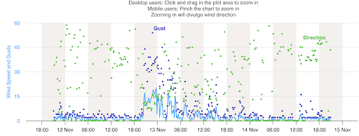
Consider the Indian Creek/Lake Crescent site shown by the red arrows.
On Tuesday evening, the winds surged across the Olympic Crest and headed down to the lower slopes where this station occurred....and things went wild. The wind went from nearly calm to almost 60 mph in a few minutes!
Pretty dramatic changes. There are more impacts of the Olympics that will have to wait until another blog, from the Puget Sound Convergence Zone to the intense low that can form on its NE side.
Another reason that Northwest weather is so interesting and fun to study.


The rainfall comparison between Seabeck and Poulsbo/Suquamish is pretty amazing, too, considering they are less than 10 miles apart...
ReplyDeleteGreat blog Cliff! My folks live about 7 miles northwest of that site near Indian Creek on the hill above Joyce at 1000 foot elevation, sometimes they get south east winds over 100mph, 128mph according to their next door neighbors weather station, it's amazing to see that trees around there can take those wind speeds, most of the big Cedars loose their tops and grow new ones then those continue to blow out at times
ReplyDeleteWhat a shocker!
ReplyDeletehttps://www.snopes.com/fact-check/project-2025-noaa-national-weather-service/
Poster "kajal" has posted spam that you approved on this blog. Please remove the spam. The same is also true on Nov. 10, on a different blog post.
ReplyDeletenever approved it. It appears that some folks have found away to hack the comments...
Delete