The latest model forecasts are consistent: an unusually powerful storm with extreme low pressure will develop rapidly offshore on Monday and Tuesday.
But there is something else not yet discussed: this extreme offshore feature may cause a downslope windstorm on the western slopes of the Cascades.
One that could easily cause extensive power failures.
The latest sea level pressure forecast for Tuesday is scary, with an intense 952 hPa low center west of the Washington coast. The strongest storm ever to hit the Northwest during the past century, the Columbus Day Storm of 1962, had a low-pressure center of 950 hPa.
The lines show the pressure analysis. Huge pressure gradients (pressure change over distance) and intense pressure changes over the Cascades. Remember this, it will be important.
The sustained wind speeds at the same time are shown below. 70 kts and more around the storm. Hurricane strength. The BC, WA, and Oregon coastal zones will get a taste of it. Expect some coastal power outages.
As in any late-night commercial, there's MORE. Much more.
The low pressure offshore will create a large pressure difference down the Strait of Juan de Fuca. As a result, winds will accelerate westward down the Strait, producing huge winds near Tatoosh Island. They don't call the western exit of the Strait the "Graveyard of the Pacific" for no reason. Rocks and wind and cloud.
The lowlands of western Washington will get a piece of the windy action as well.
Here in Seattle, it appears that winds will accelerate to 30-40 mph on Tuesday evening, which will blow down some leaves but do little damage (see wind forecast from the City Light WindWatch website, which my group runs). I will have to rake the leaves....again.
But the real wind action for the western lowlands will be on the western slopes of the Cascades, due to easterly winds driven by a huge pressure difference across the Cascades.
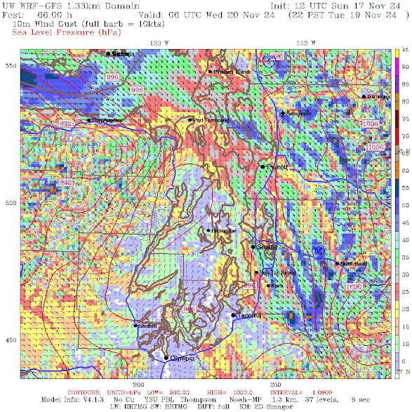
Below is the latest high-resolution model prediction of wind gusts on Tuesday evening. Easterly winds gusting to 50-60 kt (57-69 mph).
Enumclaw, Black Diamond, North Bend, and other communities near the western Cascade slopes will get bruised by strong winds. Get your candles ready.
You want to see an ultra-high resolution forecast of the winds at 10 PM Tuesday evening. Here it is! Strong enough for some power outages for sure.
\


Cliff!!!
ReplyDeleteWhat about your fans in Corvallis oregon??!!
Cliff!! What about your friends in Corvallis oregon?
ReplyDeleteWhat about oregon??!!
ReplyDeleteBetween the 1962 Columbus Day storm and the 1993 inaugural day storm, which one is this current storm likely to be most like?
ReplyDeleteWhat about the San Juan Islands? We're in a weird spot weather wise and seem to be cut out of the images as well. We never know what we're gonna get because all the meteorologists seem to forget about us. We also don't have access to services and stores to prepare the same way.
ReplyDeleteI note that UW’s Atmospheric Science “Area Forecast Discussion” for Western Washington has flipped entirely over the last 4 days. It went from probabilistic models suggesting a large ridge setting up over the western states, and affecting Western Washington, and western Washington warming and drying out, to cyclogenises and a historically deep low over the eastern Pacific. Some day, Professor, you should consider discussing how the public can gain any confidence in a modeling technology that struggles to see very far into the near future.
ReplyDeleteJohn...that discussion is made by the National Weather Service. The local forecasters have not kept up with this...very disappointing..cliff
DeleteThanks Professor. I should have more carefully constructed that comment. I’ve read that site for years and know that while it’s posted at https://a.atmos.washington.edu/data/disc_report.html it’s built by the National Weather Service. Thanks for making that clear to other readers. And ya, it is disappointing.
DeleteMaybe they're just not labeled, but what's the pressure difference between each isobar?
ReplyDelete1 hPa in this case
Delete952!! Ouch. How does the predicted track compare to the Columbus Day storm?
ReplyDeleteAs I walked the PCT over 3 summers, I often wondered why so many of the trees would get knocked over creating a mess for those of us trying to get through on a hike. I imagine a bunch of the reason lies in super saturated soils and wind while another is avalanches. It sure represents another level of power one does not typically want to witness.
ReplyDeleteAny chance the stor movement could be slightly off and that ends of impacting the whole of Seattle area
ReplyDeleteIf the 'Gold Standard' Weather.com 72 hour future forecast is to be believed, this isn't going to have much impact South of the Canadian border. Matter of fact the 40 mph gusts I had the other night, will probably have caused more damage.
ReplyDeleteHi Cliff. Great info! Thanks! So the low pressure sucks in air from all around, creating wind. Ok. What happens to the huge amounts of air it pulls in? Where does it go? Thanks
ReplyDeleteThe air rises, cools and condenses forming thick cloud layers with precipitation even thunderstorms near to the low. Rising air is associated with low pressure (except in the eye of a hurricane where air is sinking). The opposite is an anticyclone or a high pressure system or ridge. The air is sinking in an anticyclone so the skies are usually clear with light winds at the surface moving away from the high.
DeleteThoughts on a second low arriving on Friday on a much more damaging trajectory
ReplyDeletePowerline Clearance arborist for PSE over here. Bags are packed and ready for some overtime!
ReplyDelete