Each atmospheric "play" is different and according to high-resolution forecast models, I can describe the four "acts" that will unfold tomorrow.
The main protagonist of this drama is strong, but small, low pressure center that will move northward up our coast.
Note to local media: not a bomb cyclone. 😕
Below is a view of the low at 4 PM Friday (the lines are isobars of sea level pressure, the color shading shows low-level temperature.)
Nice looking low, with a central pressure of 981 hPa.
Act 1: 1 AM Friday Morning
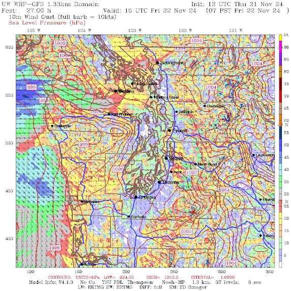
The forecast maps, with sea level pressure and near-surface winds (shading), are shown below.
As the low approaches, the pressure differences across the region will increase, with lower pressure towards the Pacific. Easterly winds, particularly in east-west gaps, are apparent. The forecast map below predicts strong winds exiting the Fraser River Valley and then heading across Bellingham, and the San Juans, with strong easterly flow over the western portion of the Fraser River Valley.
Downslope easterly winds are developing along the western slopes of the Cascades and pushing towards Kent and south Seattle. Winds picking up around the western end of State Rt. 2.
Act 2. 7 AM Friday. The Games Afoot
Southeasterly winds are increasing on the coast and the easterly winds hitting Seattle to Kent are increasing with some gusts to 30-35 mph. Far weaker than Tuesday evening, but enough to get folks nervous.
Intermission
Act 3. 4 PM Friday. Crescendo
This is what the audience was waiting for. With the offshore low making its closest approach, winds along the coast speed up considerably, with gusts reaching 50-75 mph. Some power outages along the coast. Over the lowlands of western Washington, winds turn southerly, with gusts to 30-35 mph around Seattle and 30-45 mph over northwest Washington.
Act 4. 10 PM Friday. Denouement
As the low center pulls away, the wind rapidly weakens along the coast but stays gusty around the Strait of Georgia and NW Washington.
I hope you enjoyed the drama.


Great to hear you are having so much fun. We got very little down here in Tacoma in the last storm and looks like just a typical windy day tomorrow
ReplyDeleteMt Rainier was a magnificent wind shadow.
DeleteYeah, a lot of fun being without power for 20 hours. To say nothing of the people who were killed, or had their houses destroyed by falling trees. So much fun.
DeleteThecatguy93, you sir must be a blast at parties.
DeleteI love this high resolution models even show the higher winds on the volcanoes. You can see a little spot of 75kt+ winds on Rainier in one of them!
ReplyDeleteThank you!
ReplyDeleteBravo, Cliff. As always your production allows me to learn the nonfiction version of the forecast. I shall be purchasing season tickets.
ReplyDeleteThank you!
ReplyDeleteThanks professor. Coincidentally, our barometer this morning, with no wind at our place, is almost as low as it was with heavy wind during the previous storm. I’m curious to see where it progresses to through the day, and how rapidly it does.
ReplyDeleteWho says writing or talking about the weather is boring? Nicely done, Cliff!
ReplyDeletePlease comment on the fujiwhara effect in relationship to the current weather pattern and as to how long these persist.
ReplyDeleteCliff, I was watching this 7 day satellite loop: https://www.iweathernet.com/satellite-images-and-loops/fast-7-day-satellite-loop
ReplyDeleteIt looks like Tuesday's low just spun northwest and then circled back southeast. Is it going to take a second pass at us and wreak more havoc?