Because of my research on western U.S. wildfires, I keep close tabs on the weather in southern California.
So I was more than a little interested in the extreme warnings made by the National Weather Service for densely populated portions of southern California (see below).
They call this a LIFE THREATENING AND DESTRUCTIVE WINDSTORM. An EXTREME RISK demanding immediate action. Folks are warned to stay away from windows.
Specifically, tomorrow and Wednesday morning, the NWS is predicting north to northeast winds of 30-45 mph, with gusts as high as 80 mph. They suggest the winds will blow down many trees and powerlines and that travel will be difficult. Loose objects could be blown down and fires can be started and rapidly spread.
So what is going on? The large-scale models (such as the GFS forecast of sea-level pressure and surface winds shown below for 10 PM Tuesday) predict strong high pressure over Nevada and unusually low pressure over southern Arizona, producing unusually strong northeasterly winds between them (wind speeds indicated by color shading).
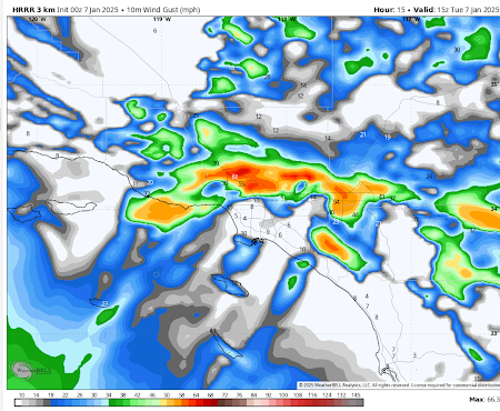
To better check out the forecast, the best place to turn is the high-resolution NOAA/NWS HRRR model.
By tomorrow (Tuesday) morning the HRRR model predicts 50-60 mph winds over the mountains north of LA
These winds strengthen during the day, reaching 70 mph over the hills by 4 PM.
Ominously, the crazy strong NE winds are predicted to descend to lower elevations overnight, particularly near Malibu, where the fires occurred several weeks ago (4 AM Wednesday is shown).
And the situation remains very serious at 8 AM Wednesday.
Folks, this wind event has the potential to produce major wildfires, and as a result, Southern California Edison is planning massive power shut-offs the next day (see map below). The yellow circles with the bell symbols are where they plan on having Public Safety Power Shutoffs (PSPSs). Tens of thousands of customers will lose electricity in the hope of preventing powerlines from starting fires.
Finally, let me note that this event is very, very unusual for this time of the year.
I can show this by displaying the heights and winds at 925 hPa (about 780 meters above sea level). You can see the low over southeast Arizona. The shading is something called the standardized anomaly from climatology (sorry). All you need to know is that the light gray areas indicated the winds were essentially unprecedented.


Hi, I grew up in Pasadena and this appears to me as a classic Santa Ana wind event. (Low pressure in the west and high pressure in the desert, with compressed winds over the mountains rushing to the sea). I am deeply curious on what makes this one extra special to issue the warnings. Is this a stronger than normal pressure differential? I understand the fire precautions but why such widespread mandatory power shut-off? Thanks!
ReplyDeletePart of the problem is that it's been so dry. For example, Long Beach only got 0.04 in December and less than 1 inch so far this season. And there is so much dry and dead growth. People are comparing this to other destructive Santa Anas, like one in December 2011.
DeleteLooks like the very worst has happened. When this is all said and done I hope we won’t discover an irresponsible utility with all the advance warning they could have asked for left the power on where they shouldn’t have.
ReplyDeleteYes- California, more than about anywhere else, burns because of man-caused problems. Whereas, many other places have lightning, costal CA rarely does, and not under Santa Ana conditions; with low humidity and high winds, there are few causes for natural fires but the conditions are ripe for any idiot with a carelessly tossed cigarette, not to mention power lines, automobile mufflers in the grass, arsonists, etc. It is, unfortunately, the "perfect storm" for fire.
ReplyDeleteIn these kinds of strong winds, a run-of-the mill house fire from the usual causes can spark a conflagration which quickly spreads downwind through the neighborhood where that house is located, and then beyond.
DeleteWe visited Borrego Springs over Christmas break. The state park visitor center noted that the cumulative rainfall at the visitor center since July 1 was zero (0) inches. Up in the highland between San Diego and the desert are lots of homes nestled in the forest and in the chaparral. What could go wrong?
ReplyDeleteIs standardized anomaly from climatology equivalent to (or, measured at the same scale as) standard deviation of wind speed in that area ?
ReplyDeleteThe Blancolirio aviation safety channel, January 8th SoCal fires update:
ReplyDeletehttps://youtu.be/gunenpZ5JuE
The Lookout wildfire tracking channel, SoCal Day 2:
https://youtu.be/OjE9xVU4eUA
It is pointed out in the Blancolirio video that occasional wildfires are a part of the chaparral desert landscape ecosystem. Wet periods promote its growth; periods of drought burn it off.