Does your skin feel feel dry? Cracks in your skin? Feeling chilled?
There is a reason: modified Arctic Air has spread over western Washington. And yes, cold, dry air is over eastern Washington as well.

Temperatures this morning (6 AM) were the coldest so far this year for many Washington State locations. Temperatures dropped into the twenties and teens over western Washington, while single digits and even below-zero temps were observed in eastern Washington.

In such situations, there are often great temperature contrasts in western Washington between locations near the relatively warm Puget Sound and locations away from the water. For example, one location in West Seattle was 30F while temperatures dropped to 18F in Redmond. A chilly morning in Microsoft land.

A little cold-air tutorial first (as a professor of atmospheric and climate science I can't help myself 😀)
This time of the year, very cold air from northern Canada moves southward into the interior of the continent. Such air generally does not get into western Washington because of the "protection" of two mountain ranges, the Rockies and the Cascades.
This time of the year, very cold air from northern Canada moves southward into the interior of the continent. Such air generally does not get into western Washington because of the "protection" of two mountain ranges, the Rockies and the Cascades.

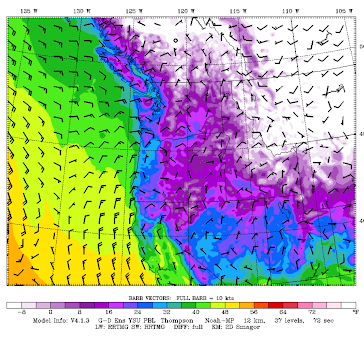
As shown by the figure below, for the cold air to get into western Washington the easiest (and lowest elevation) route is through the Fraser River Valley, exiting north of Bellingham (blue arrow), Cold air from the interior of BC can also move into eastern Washington through the Okanogan Valley (orange arrow).
Once the cold air gets deep enough in eastern Washington, some can move over the Cascades, but that air is warmed by compression as it descends the western slopes of mountains (red arrow).

Last night (10 PM), there was very cold air at the surface west of the Rockies and in the interior of BC (white color), with modified (warmed) Arctic air invading eastern Washington (purple color).
The "invasion" of cold, dry air from the BC interior through the Fraser River Valley was very obvious at 2 PM yesterday (Monday), with strong northeasterly winds (red colors are gusts in mph) and very low dew points (blue colors).

At Bellingham, the surge of strong northeasterly winds, with gusts to nearly 45 mph, was clearly evident yesterday as the Arctic air moved in (see below).

By later in the day, the dew point--an excellent measure of the dryness of the air--- started to plummet from nearly 30 to under ten. The mark of the Arctic! The temperature dropped later.

So no need to travel to Inuvik or Yellowknife, you are breathing the air from those regions today.
Yes, I have had enough. Bring back that moist and competitively warm marine air! This is the latest cold snap of this intensity that I have ever seen here.
ReplyDeleteBut I am happy...this lengthy cold snap has at least delayed the advent of bees, usually beginning to show up at the end of January...Bumblebees in particular!...Yes, I have a phobia about bees! Have not even seen one here in Everett--although I did get buzzed by a large fly this AM!!!
DeleteIn my experience most "bee type bugs" mind their own business- with the notable exception of yellow jackets. For some reason these get more ornery as summer wears on. August and September probably have the highest risk of getting stung- especially when bushwhacking through the forest! Anyway, it'll be at least a couple months. I was afraid of them as a kid after I got stung once too often, but now I get through about half the years without a sting. Bumblebees may be big and noisy but they generally mind their own business. I only got stung once by one that got inside my clothing.
DeleteLove your info Cliff - ALL of it! So fun and fascinating and Thank You So Very Much!
ReplyDeleteThis cold air really affects photography. The air this morning was roughly 20 degrees warmer than Puget Sound. My new cam has a very powerful zoom lens and is dramatically affected with wavy, jumpy images due the the inferior mirage effect. Most of my distant shots are at least 8 miles away. Bush Point is 8 miles away. I am staying away from shots like that due to image quality issues. The things we have to put up with in the Pacific NorthWET.... :)
ReplyDeleteBut it depends on what the photographer wants.. the distortion might ADD interest to their photograph.
DeleteSkunk Bay... I presume you meant to say 20 degrees COLDER than Puget sound? Twenty degrees warmer would feel real nice about now!
DeleteYes I did. I tried to edit it right away and it never made it didn't make it....
DeleteI miss my favorite weather: 50° & raining!
ReplyDeleteLooks like Portland is set for its traditional Gorge winter weather by Friday; those east winds are pretty run down as they turn twice to find us near Longview! We seldom see ZR up here, but fingers crossed.
ReplyDeleteI'd like to know what happened in January 1950. There were repeated stretches of frigid temperatures punctuated with warmer (yet still cold enough for snow) systems moving through, but there were also a few days with both frigid weather AND plentiful snow. That's not usually the pattern that winter in Seattle follows.
ReplyDeleteI was 15 years old growing up in Seattle in 1950 and that winter was one which really got me interested in meteorology. The weather pattern which developed just after Christmas of 1949 and continued through January 1950 featured a similar pattern as the current one, with a persistent high pressure area over the Eastern Pacific extending northward into Alaska with Washington staying under a colder northerly flow much of that time. On January 13 a low pressure storm broke through the ridge and moved rapidly southeastward and across southern Washington near the Oregon border, at the same time as a surge of Arctic air dropped southward from British Columbia into Washington. The result was a true blizzard in Seattle with strong northerly winds, falling temperatures in the middle of the day and blowing and drifting snow. The temperature when I left home for school that morning was 28 and when I got home in the afternoon, it was 13 degrees with a strong north wind, fine powdery blowing snow with drifts up to my knees. The cold weather that followed lasted about a week, then a warmer storm brought more snow which changed to rain with a brief warm up for a day or two, then another cold wave which lasted thru the rest of the month into early February and sent temperatures down to near zero at the end of the month. I skied across Green Lake one day on ice covered by several inches of snow. The winter cold spells we have had recently are puny compared to the winters of both 1949 and 1950.
DeleteI was only 4yo in 1950...but I do have vague memories of mom and dad having to clear a path from our front door, to the street. The snow was nearly 2' high, eventually. Later on in the decade, we had several snowy winters, providing my youth with lots of sledding adventures in N. Seattle!..My family has just a couple of small photos of my, dad, and my two siblings, sledding down a local street, and then coasting for around two city blocks...simple fun! It does seem like the 1950s and 1960s in Seattle had more snowfalls, then in the next 50 years or so.
DeleteThat (1950) was before my time but it was probably Seattle's coldest in recorded history. With an avg. January temp. of 25 degrees it was COLDER than my old home, Connecticut.
DeleteI remember that winter - ice a quarter of an inch thick on the inside of my bedroom window.
DeleteQuestion: if the air warms by compression after coming down from the mountains, why doesn't it cool the same amount rising into the mountains from the east, making it an even tradeoff, rendering its mountain experience a wash?
ReplyDeleteMy guess is the air that hits the west side of the mountains is likely to have more moisture (and a different thermal capacity) than the air that descends the east side.
DeleteAs far as late cold and snow, March of 2009 saw a brief, intense band of snow largely confined to the western slopes abutting Puget Sound, particularly in West Seattle and the higher elevations southward into Burien. This weather was particularly unwelcome as I was renovating a structure without heat!
ReplyDeleteCliff, I am interested in the extended period of dry weather we’ve had from Eugene north to the border. My weather app says we’re at about one quarter our normal rainfall for the last 30 days, and I know that extends back to around the first week of January. Is there precedent in Western Washington for this day off a winter? And what consequences are we looking at in the summer?
ReplyDeleteFeet (per picture), also hands, finger nails, nasal passages. Thanks for the reminder. Our indoors was 25% relative humidity, creeping up slowly. I think I will keep a humidifier in our storage area.
ReplyDelete