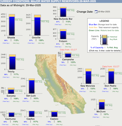
On April 1, water managers and others often appraise the water situation as the wet season ends and the dry West Coast dry season approaches.
So a day early, let's get a look.
For the water year (since October 1), the Western U.S. has been a mixed bag, which is not unusual. Eastern Washington, most of Oregon, and northern California were considerably wetter than normal (see percentage of normal precipitation below). Western Washington and central California were modestly drier than normal, while southern California and Nevada were much drier than normal.
With most of the large reservoirs in northern CA and last year being wet statewide, most CA reservoirs are in very good shape with lots of water (see below).
Looking at river levels, which reflect precipitation during the past weeks, many rivers are running above normal in Washington, Oregon, and northern California, and near normal in most of the rest of California. Good for fish.


Yes, this year has been very much within "range of normal" here in the northwest corner.
ReplyDeleteAs for summer weather predictions, I've come to wonder how much impact volcanic eruptions have on Pacific water and air temperatures (how much those contribute to "pineapple express" and "atmospheric river" events). Summers can be very temperate, with occasional wet "4ths of July," rainy Bumbershoot events, and county fairs. Has anyone ever studied the correlation of Hawaiian (and Pacific rift) volcanism to weather patterns? Just curious!
North of Cle Elum, the heavy rain early last week has brought muddy water down off the mountains. I crossed the Teanaway River that runs into the Yakima River 4 miles east of Cle Elum. The color was about like peanut butter. Stream velocity was fast but there wasn't flooding.
ReplyDeleteLooking at the Washington subbasins gives a more detailed look at both SWE as well as precipitation.
ReplyDeleteThe high country around Mount Baker is an interesting case in that current SWE is 73% of median in the Nooksack basin and 79% of median in the Baker River basin. Total precipitation for the water year to date, however, is 91% of normal in the Nooksack Basin and 89% of normal in the Baker River basin.
The incongruence between SWE and total precipitation values would seem to point to overall above normal temperatures within these areas leading to noticeably decreased snowpack despite near normal total precipitation (i.e. more precipitation fell as rain and less fell as snow).
This contrasts with the important Upper Yakima basin which currently has 78% of median SWE and has received 80% of it's median total precipitation for the water year to date. Thus, it's more likely that temperatures in this region were overall closer to normal given the similarity between the total precipitation and SWE values (i.e. the ratio of precipitation falling as snow to precipitation falling as rain was essentially normal in this area).
Go to www.skitheloup.com look at their webcams. This is just since this morning. Impressive amount snow for how warm it is. Snowpack will be fine.
ReplyDeleteThis comment has been removed by a blog administrator.
ReplyDelete