During periods of less active weather, when the storms are not hitting us regularly, a pronounced daily wind speed variation is quite evident in our region.
Winds are generally weak overnight and into the early morning and then rev up during the late morning/afternoon, often peaking around dinner time.
Consider the sustained winds (averaged over two minutes) during the last three days at four Western Washington locations.
At Westport, on the central Washington coast, the wind was near calm overnight and then sped up to around 15 mph around noon and stayed strong until around 7 PM, when it declined rapidly.
Westport
Moving to north Seattle (Sand Point), the daily (diurnal) wind variation is just slightly weaker than on the coast, with the acceleration starting a few hours later.
Seattle Sandpoint
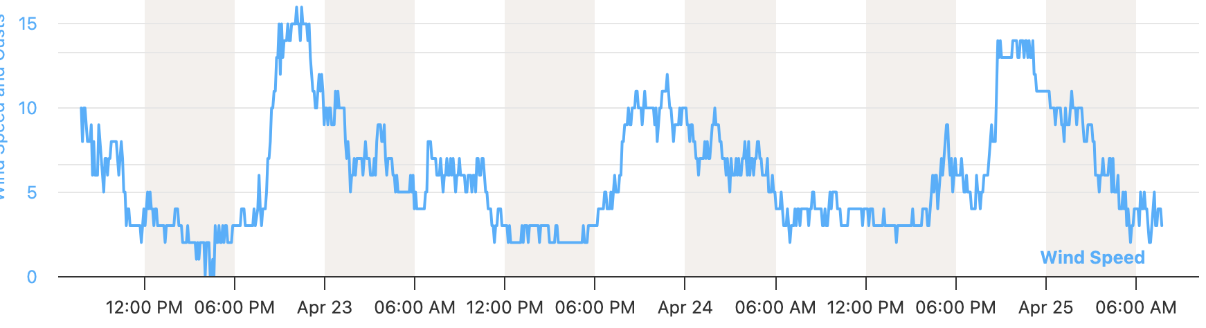
What about the New Dungeness Lighthouse, which observes the winds in the eastern Strait of Juan de Fuca? A nice diurnal variation, but quite different. Winds peak in the evening there! Why?
New Dungeness
Finally, consider the winds at Olympic Airport, several miles from the water. They have a daily wind variation, but a bit weaker than the others, with near-calm conditions at night.
Olympia Airport
So, how do we explain this complex daily variation of wind speeds?
First, there is the daily variation in vertical mixing of air. Winds are generally slower at the surface, with a rough surface and structures slowing down the wind (see below)
As the surface warms, the air starts to convect, producing mixing in the vertical that brings down the stronger winds from aloft down to the surface. Winds thus increase during the day.
Second, we have all kinds of regional sea breezes. When land heats up relative to the water, a pressure difference is created (lower pressure on land), producing an onshore wind...the sea breeze (see illustration).
This explains the strong sea breeze on the coast.
Seattle gets some sea-breeze action as well. In this case, the Sound Breeze, which is a sea breeze between the mostly land area of central Puget Sound and the cold water of the Straits of Juan de Fuca and Georgia (see below). It is a northerly winds the increases during the mid to late afternoon and weakens around 8 PM.
Olympia Airport has a weakened daily variation of winds, with far less sea breeze or Sound Breeze influence.
However, Olympia AP winds respond to the difference in the increased vertical mixing as the land heats up during the day (and Olympic Airport has a more continental climate and tends to warm up more during the day than Puget Sound locations).
Finally, there is the interesting case of the winds in the eastern Strait...with the Dungeness Lighthouse winds shown above.
The diurnal wind variation there is very different, peaking in the evening. Why so late?
The answer is that the winds in the Strait are responding to a larger-scale "sea breeze." One between eastern Washington and the coast.
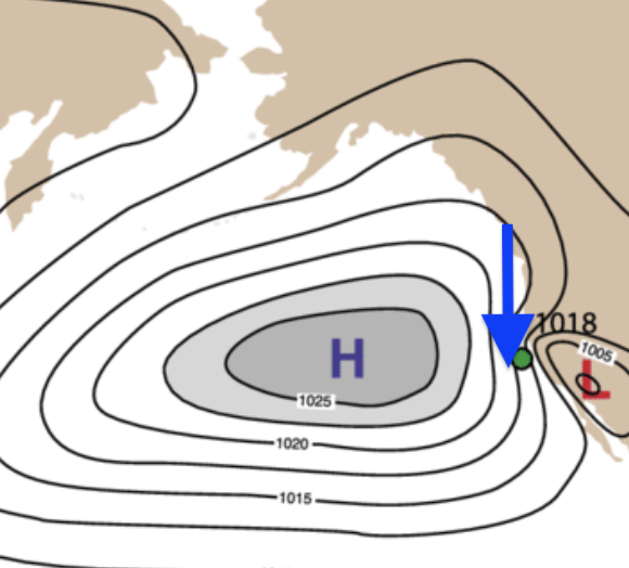
The Columbia Basin heats up during the day, causing pressure to fall (warm air is less dense--or heavy--than colder air). So a pressure difference develops during the day (higher pressure on the coast, lower pressure east of the Cascades), and the regional winds react to that. To illustrate, below is the sea level pressure on Thursday at 6 PM--you can see the higher pressures on the coast compared to the interior.
Being larger in scale, it takes more time for the winds to react to the regional pressures...thus producing the evening maximum of westerly wind over the eastern Strait of Juan de Fuca.
Westerly (from the west) winds tend to rev up during the evening over the eastern slopes of the Cascades for the same reason. They are responding to the regional pressure differences.
In short, there are fascinating local diurnal wind variations that become quite obvious when we have sunny skies and a lack of incoming weather systems.
If you ever plan on flying a kite or taking out a sailboat, such information is of great interest.