April 29, 2025

Los Angeles and Seattle Switch Meteorological Places

 I am giving a talk next Tuesday in Forks on the Great Cyclones of the Northwest (details below)

Here are temperature predictions for two cities, one for Seattle and the other for Los Angeles.  Can you guess which is which?  One doesn't get out of the mid-60s (with lots of clouds!).  The other will be in the 70s with plenty of sun.


Amazingly, Seattle is the warmer one.

The last few months have been dominated by a recurring pattern in which a ridge of high pressure builds over the Pacific Northwest, while a trough of low pressure descends into southern California.

And it is happening again.  Consider a sequence of upper-level maps ( for 500 hPa pressure, about 18,000 ft).  

On Thursday morning at 5 AM, a major ridge is found over the Northwest (red colors indicate high pressures/heights), while a weak trough is over LA.


By Saturday morning, a very strong trough/low is found over southern CA.


And by Monday morning, the low trough over southern CA is even stronger:


Folks in LA will be traveling to Seattle for warmth and sun.

The newspaper reflects the difference.   The LA Times talks about rain and mudslides in California.


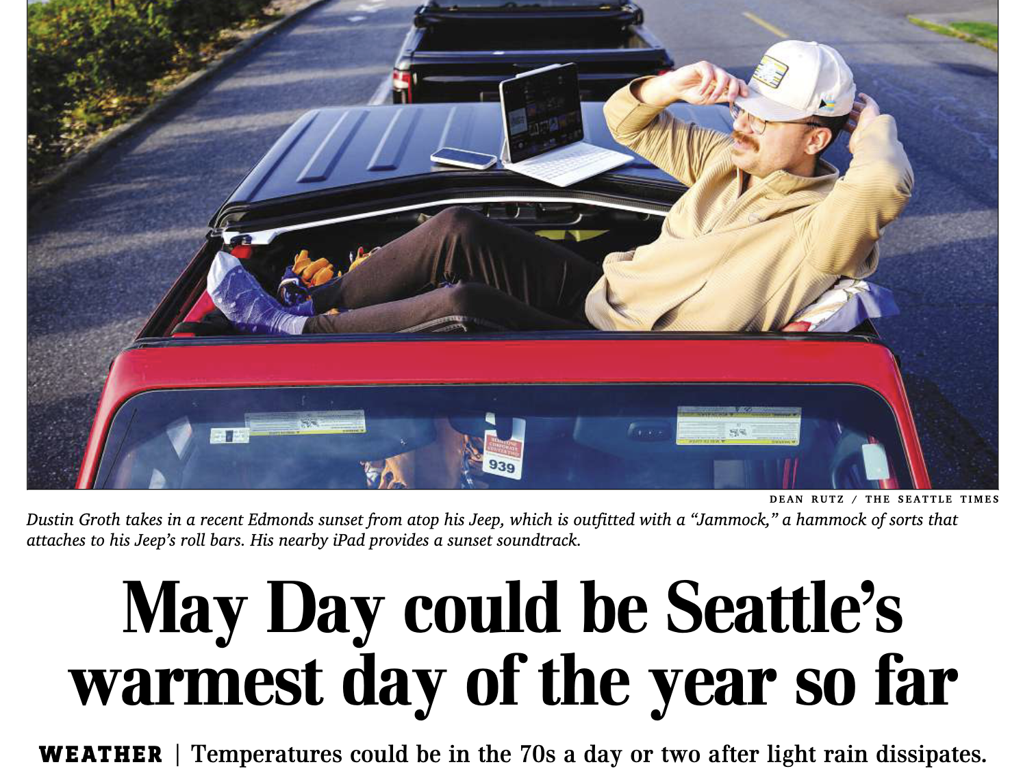
While the Seattle Times crows about the warmth.


This weather boon will not last forever, with a  few showers coming in on Saturday across the Northwest.
__________________________________

I will be talking at the UW Olympic Natural Resources Center at 7 PM on Tuesday, May 6.   Open to all and free.  My topic will be "The Great Storms of the Northwest Coast."  They zoom it as well.


April 27, 2025

Cool Water Near the Coast

 The temperature of the coastal ocean is so important for Northwest meteorology that I like to keep a close watch on it.

So let's see what is going on right now.

Below is the difference from normal of surface ocean temperatures (the anomaly from climatology in weatherspeak).  Much of the NW coast is cooler than normal (blue colors), particularly south of the capes.


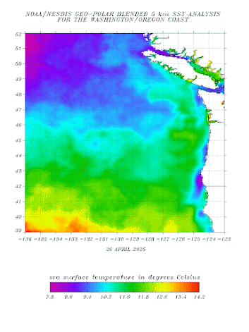
Here are the actual sea surface temperatures (not anomalies),at much higher spatial resolution.  Several; areas near the coast are as cool as 9°C (48°F), with an even cooler water south of Point Blanco, on the Oregon Coast.

When winds are northerly (from the north) along the Northwest coast, coastal upwelling of ocean water occurs.  As shown by the attached figure, such upwelling brings colder water from below up to the surface.


This upwelling is enhanced south of Cape Blanco when there are northerly winds, for reasons I can review in a future blog.

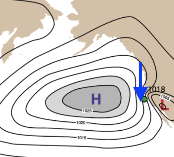
To get upwelling along the West Coast, one needs northerly coastal winds....and such winds are associated with high pressure offshore (see schematic map below).


During the past month, the Pacific sea level pressure has been stronger and farther north than usual, as indicated by the sea level pressure anomaly map (difference from normal, with red indicating above normal pressures).


This has resulted in stronger northerly winds than normal and greater upwelling of cold water from the ocean depths.  The high pressure offshore has also resulted in drier-than-normal conditions over our region.  

April 25, 2025

Why Winds During the Afternoon and Near-Calm at Night?

During periods of less active weather, when the storms are not hitting us regularly, a pronounced daily wind speed variation is quite evident in our region.

Winds are generally weak overnight and into the early morning and then rev up during the late morning/afternoon, often peaking around dinner time.   

Consider the sustained winds (averaged over two minutes) during the last three days at four Western Washington locations.

At Westport, on the central Washington coast, the wind was near calm overnight and then sped up to around 15 mph around noon and stayed strong until around 7 PM, when it declined rapidly.


Westport

Moving to north Seattle (Sand Point), the daily (diurnal) wind variation is just slightly weaker than on the coast, with the acceleration starting a few hours later.

Seattle Sandpoint

What about the New Dungeness Lighthouse, which observes the winds in the eastern Strait of Juan de Fuca?   A nice diurnal variation, but quite different.  Winds peak in the evening there!  Why?

New Dungeness

Finally, consider the winds at Olympic Airport, several miles from the water.    They have a daily wind variation, but a bit weaker than the others, with near-calm conditions at night.

Olympia Airport

So, how do we explain this complex daily variation of wind speeds?

First, there is the daily variation in vertical mixing of air.    Winds are generally slower at the surface, with a rough surface and structures slowing down the wind (see below)


As the surface warms, the air starts to convect, producing mixing in the vertical that brings down the stronger winds from aloft down to the surface.  Winds thus increase during the day.


Second, we have all kinds of regional sea breezes.  When land heats up relative to the water, a pressure difference is created (lower pressure on land), producing an onshore wind...the sea breeze (see illustration).


This explains the strong sea breeze on the coast.  

Seattle gets some sea-breeze action as well.  In this case, the Sound Breeze, which is a sea breeze between the mostly land area of central Puget Sound and the cold water of the Straits of Juan de Fuca and Georgia (see below).  It is a northerly winds the increases during the mid to late afternoon and weakens around 8 PM.


Olympia Airport has a weakened daily variation of winds, with far less sea breeze or Sound Breeze influence.  

 However, Olympia AP winds respond to the difference in the increased vertical mixing as the land heats up during the day (and Olympic Airport has a more continental climate and tends to warm up more during the day than Puget Sound locations).

Finally, there is the interesting case of the winds in the eastern Strait...with the Dungeness Lighthouse winds shown above.  

The diurnal wind variation there is very different, peaking in the evening.   Why so late?

The answer is that the winds in the Strait are responding to a larger-scale "sea breeze."    One between eastern Washington and the coast.   

The Columbia Basin heats up during the day, causing pressure to fall (warm air is less dense--or heavy--than colder air).   So a pressure difference develops during the day (higher pressure on the coast, lower pressure east of the Cascades), and the regional winds react to that.   To illustrate, below is the sea level pressure on Thursday at 6 PM--you can see the higher pressures on the coast compared to the interior.


Being larger in scale, it takes more time for the winds to react to the regional pressures...thus producing the evening maximum of westerly wind over the eastern Strait of Juan de Fuca.  

Westerly (from the west) winds tend to rev up during the evening over the eastern slopes of the Cascades for the same reason.   They are responding to the regional pressure differences.

In short, there are fascinating local diurnal wind variations that become quite obvious when we have sunny skies and a lack of incoming weather systems.

If you ever plan on flying a kite or taking out a sailboat, such information is of great interest.


April 22, 2025

Washington's Only Nuclear Power Station Will Be Shut Down for Two Months, Can Wind Energy Fill The Gap?

The only nuclear power plant in Washington, the Columbia Generating Station, is now being refueled and repaired, having been taken offline on April 11.  


There is a reason they decided to do this on April 11th and not during December or February.  

Why?  Because this is the season of rapid increase in wind energy in the Northwest and a time of substantial water inflow behind local dams, which should greatly assist in providing needed power.  


Take a look at the BPA generation numbers of the past week.   Green is wind generation.  

Big increase on April 19th, with wind producing almost a third of the power provided by hydro (blue) 


The origin of this wind energy bounty is from a recent increase in winds over eastern Washington, something illustrated by winds last week at Ellensburg.  The sustained wind accelerated to over 25 knots (29 mph)!

Considering the wind speeds during the past year at Ellensburg, you can see the ramp-up of winds in March after a low-wind winter period (November to March).    The wind energy season has begun and will continue through the summer.

But why, you ask.  Why is winter so bad for wind energy generation?  Surely, more storms are coming in during the November-February period, such as the famed bomb cyclones of last November.

But not in eastern Washington.   Cool, dense air settles into the Columbia Basin, creating a dead-air zone over most of the wind turbines in our region (see wind farm map below).  Western Washington is windy.  Eastern Washington is not.


Strong winds east of the Cascades are associated with winds from the west.  

Generally, this requires high pressure to the west of the Cascades and lower pressure to the east.  As shown below, from January to February, the opposite situation exists, mainly due to low-pressure systems over the northeast Pacific and the Gulf of Alaska (sea level pressure is shown).
In contrast, the situation from April to May is reversed, with higher pressure over the ocean and lower pressure inland.   Good for wind energy generation in eastern Washington!

With such a pressure pattern, air from western Washington can accelerate eastward, descending the eastern slopes of the Cascades or moving to the east through the Columbia Gorge.

Two recent UW WRF model forecasts show the wind pattern well (see below), with the yellow and orange colors indicating the strongest winds (on the eastern slopes of the Cascades and adjacent areas)


Ellensburg and the Columbia Gorge regions are favored because the Cascades are lower there.    The strongest winds are in the early evening, following the daily warming in the Columbia Basin (which causes pressure to fall there, since warm air is less dense than cold air).

The bottom line: there should be plenty of wind power during the next months, reducing the need for nuclear energy.  


April 19, 2025

Current Sea Surface Temperatures and the Sinking of the Titanic

 There are many similarities between the sea surface temperatures and atmospheric structure during the past week and those observed during the sinking of the Titanic on April 14-15, 1912.  

Should marine traffic today be worried about icebergs?   The answer is revealed below!


Examining the sea surface temperatures (SSTs) today (below), you will notice cool water (around 50F) off our coast, dropping into the forties to our north.   Temperatures slowly warm to our south, only hitting about 60°F in San Diego.  Not very exciting or unusual.

But if you want dramatic sea surface temperature contrasts, head to the East Coast. 

East of New England, ocean temperatures are in the upper 30s and 40s and are even colder near Newfoundland.

There is a huge increase in temperature south in a zone east of Maryland/Delaware.  This warmth is associated with the northern extension of the Gulf Stream moving along the southeast coast.


Below is an expanded view of the above:  amazing sea surface temperature changes over tens of miles.  


 As you can imagine, there are similarly large near-surface air temperature contrasts.  To illustrate, consider the air temperature at 2 meters above the surface this morning (below).  Air temperatures range from below freezing near Newfoundland to around 70°F over a few hundred miles to the south.   

As we will see, there are real dangers associated with this pattern....dangers that may well have destroyed the Titanic.


Let us go back to April 14, 1912.  Below is the near-surface (1000 hPa pressure) air temperature analysis for that date.  

Very similar to today's pattern: very cold east of northern New England and eastern Canada, with rapid warming to the south.
How could this weather pattern have led to the demise of one of the largest passenger ships of the era, with an experienced captain and crew?

As all of you know, the Titanic was sunk by a collision with a large iceberg, which was not seen as it approached.

It appears that the iceberg was not seen because of a mirage phenomenon:  a superior mirage caused by cold air near the surface and warmer air aloft.

When there is a large temperature increase with height, the atmosphere acts as a lens, causing objects to be elevated higher than they really are (see schematic below).

Courtesy: Ludovica Lorenzelli, DensityDesign Research Lab"

We see such superior mirages all the time here over Puget Sound, when warm air spreads over the cold water (see example below).  Not how the land is elevated upwards.


So, how does this explain the inability of the crew of the Titanic to see the approaching iceberg?

With cold air near the surface and warm air just to the south, one can get warm air riding over the cold air if southerly (from the south) winds develop (which happens very frequently)

Courtesy:  Charles Floyd

This configuration of cold air overtopped with warm air creates a lens that creates a superior mirage in which the image of the ocean surface is elevated, obscuring the approaching iceberg, with tragic results.

Courtesy:  Charles Floyd


A very similar situation happened today.  Examining the vertical temperature structure today at a point near the Titanic tragedy (red dot, solid lines are sea level pressure, first figure), the dangerous situation was evident.


There is a plot of temperature with height at the point.   It's there.  Cold near the surface, with rapid warming just above.


And there WERE icebergs out there today!  On the figure below, the blue dot shows the position of the sinking of the Titanic, the red line shows the boundary of the iceberg fields, and the numbers show how many icebergs were in each box.


But today, there is little issue with safety.  Satellites give us the ability to track icebergs, and ships have highly capable radars that can spot them far ahead.

Worry about icebergs in our area?  Although there are many occurrences of warm air over cold water in Northwest waters, there are no icebergs in our waters.😊

April 17, 2025

The Day of No Weather and SuperBlue Skies

When I get up in the morning, one of the first things I do is check the latest satellite image.

Today's imagery (below) was stunning: not a single cloud in the sky


Nearly all my blogs are about some interesting weather feature...the more severe the better.  

But what to talk about on the most boring weather day in years?

When I got to the UW this morning, I took pictures of the sky ..the most perfect blue skies I could remember.


Viewed from the Seattle PanoCam this am, the light from the blue sky on Puget Sound gave the water a super-blue tint.


So why was the sky so clear?

The upper-level (500 hPa, about 18,000 ft) weather map at 11 AM  explaines a lot.   There was a strong ridge or high offshore, and such features have powerful downward motion on their eastern side...which prevents cloud formation.


Sinking air causes warming by compression and relative humidity to drop (since warm air can "hold" more water vapor than cooler air).  This prevents cloud formation.

The predicted relative humidity at around 10,000 ft (700 hPa pressure) was extraordinarily dry, with dark blue colors indicating relative humidities below 30%.


The solar radiation today was unimpeded, resulting in the variation over the day being almost a perfect cosine shape (the values at Snohomish are shown below).

Why is the sky blue on clear days?

Light from the sun has all wavelengths of visible light.   Atmospheric molecules scatter short wavelengths (like blue) more than longer wavelengths (like orange and red).  As shown in the image below, this preferential scattering of blue light makes the sky look blue.


Water droplets and particles (such as from wildfire smoke) scatter all wavelengths similarly, giving the sky a whitest cast.


As you can imagine, small particle concentrations were very low today, as shown by the PM2.5 numbers (concentrations of particles of 2.5 microns or less) around Seattle (below).  With clear skies, low relative humidity, and clean air, no wonder our skies were amazingly blue.


Enjoy the blue skies....clouds move in over the weekend.


The Atmosphere is Now in Neutral

Midway through May is a good time to check on the status of El Nino/La Nina,  since its status becomes clearer at this time of the year and ...