If you were thinking of putting away your umbrella or rain jacket for the summer season, think again.
Substantial precipitation is coming to the Northwest, including high-elevation snow.
In this blog, I have sometimes evaluated the scientific validity of the Drought Monitor graphic, which often exaggerates "droughts". For example, below is the latest graphic, which suggests moderate drought over the western side of the Cascades.

Comparing this to the percent of normal precipitation for the current water year (starting Oct. 1), we see that eastern Washington and most of Oregon have been wetter than normal (green colors), while western WA and the Cascades are 70-90% of normal.
We get more more precipitation than we need. For example, the water levels for the Seattle reservoirs today is ABOVE normal (see below). The huge Spada Lake reservoir that provides water for Everett is the same.
So starting in a good position, we are about to be hit with lots of rain during the next few weeks....much more than normal. Substantial precipitation now is golden---filling reservoirs and streams and moistening the ground before the dry, summer season.
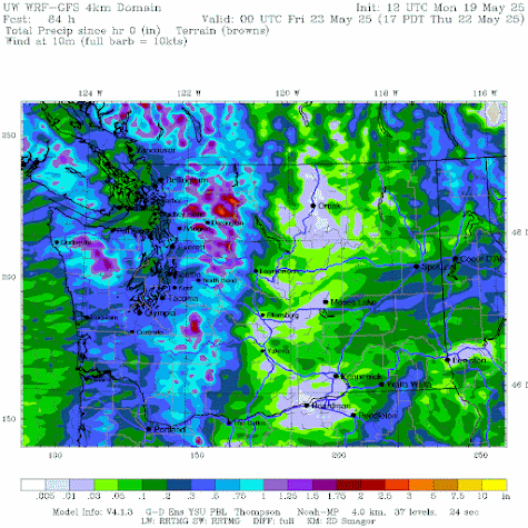
We start with a weak system coming through on Tuesday and Wednesday, which will give the region a good wetting, with about a third of an inch over the lowlands and up to 2 inches in the mountains (the total through Thursday at 5 PM is shown below). Enough to keep the lawns green.
But the really impressive action is predicted for next week. A very large and deep low will develop in the Gulf of Alaska (11 AM on 27 May shown)
The 5-day precipitation total ending at 11 PM 30 May is shown below. Up to 3.5 inches of additional precipitation in the mountains. Enough to quiet any drought talk for a while.
And with a cold, low-pressure area offshore, we will even get substantial snow in the mountains (see forecast below). Enjoy....


Enjoy? Really? Some of us are still waiting for our mid-spring warm spell... And there seems to be no such thing as warm rain here. Please tell me where to go for Memorial Day weekend... the nearest sunny spot.
ReplyDeleteAt least for now the weekend forecast looks promising. I can handle rain during the work week!
DeleteCliff come on over. Loving this. Was snowing around 5000ft this morn. Best morel year this year too. Camping in cool/cold with nice campfire been better than past years.
ReplyDeleteI'm all in favor of wet Spring. The landscape loves it, and by the second weekend of July all is forgotten.
ReplyDeleteFull reservoirs are nice but what about fires. That might be more of what the Drought Monitor is worried about. Fires have started in Minnesota (!!!) and Arizona. So fingers crossed.
ReplyDeleteSpot-on again, Professor! We had 1.04" "in the tube" at 7 am here, with fairly heavy fresh snow above at about 3000 ft. (have photos). I'm not sure how many convergence-slash-'climate zones' exist in this county (three? four?) but we get a kick out of spring weather here in the north Cascade headwaters, here in Whatcom. (Continuing drought, burn-ban around the corner no matter how wet things are.)
ReplyDeleteCliff, in past posts you have taken WA officials to task for not doing more to adapt to dry years. Here, you're saying "Western WA does not need 100% of normal precipitation to be fine." Are these mixed messages?
ReplyDeleteJerry.... you message does not make any sense to me. What messages did I wrote calling WA State officials to task for not adapting to dry years? And yes, it absolutely true we don't need 100% of average precip to be fine..cliff
DeleteIt is nice that this the systems are cold. This means less flooding. It also means that a lot of the moisture piles up in the form of snow instead of just overflowing reservoirs. This is better as we get into the dry season.
ReplyDeleteMy lilacs have bloomed in time for the snow Maybe they’ll bloom twice
ReplyDeleteLong range forecasts from accuweather and weather channel for lowlands not indicating much rain from May 27-30, maybe .25" ?
ReplyDeleteNow they are showing trace amounts through June 6
DeleteExpect the Seattle Times Climate Lab will still report the worse case drought scenario even when people are wearing galoshes in late May.
ReplyDeleteSoo… what happened to this front? I’m seeing no rain beyond a sprinkling this Monday morning, on rhe 5 day forecast. Help!!! Western Washington here is WAY too dry from this winter for a comfortable summer
ReplyDeleteCliff: why didn’t you show the combined storage graph for the Yakima basin? It’s only at 63% capacity and the Roza district is rationing water to farmers.
ReplyDelete