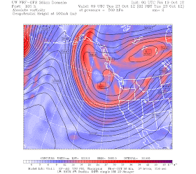
By Saturday, deepening upper level troughing will develop over the Gulf of Alaska. This trough is associated with cold air, and the tight packing of the height lines suggest strong jet stream winds.
During the next few days (Tuesday AM), the trough plummets southwards, bring much colder air over the NW (see graphic below)
The Climate Prediction Center's 6-10 day forecast shows the result of this pattern: a high probability of below normal temperatures (dark blue colors) over the NW and California. This air will be cool and unstable, and the result will be snow in the mountains. How much? Lets check the model forecast!
First, for the 24-h ending 5 PM on Saturday. Up to 8 inches in the north Cascades and mountains of southern British Columbia, with lighter amount spreading down into norther Oregon.
The next 24 hrs (ending Sunday at 5 PM), the same thing.
Then early next week the snow picks up again in the Cascades and extends over the Sierras.
The snow level by the end of the weekend will drop to around 3000 ft, so even Snoqualmie should see some white stuff. Stevens is a sure thing. This is good news for the Ski folks...they are going to get a good start to a base on their higher runs. El Nino has weakened and in any case the first part of the autumn is not influenced by it much anyway.
This is all great impetus for us to get our application Seattle SNOWWATCH ready for this winter, with new capabilities that I will describe in a later blog.


Just to clarify your point... The CASCADES will get their first real snow starting late TONIGHT and on SATURDAY. It is the SIERRAS that have to wait until MONDAY for their first good shot of snow. Looks like the CASCADES continue to see periods of snow through early next week, but the main impulse of snow is on SATURDAY and early SUNDAY.
ReplyDeleteCliff,
ReplyDeleteEl Nino has weakened? Are we heading toward a neutral year? Or is it still going to be mild El Nino? Thanks!
Cliff, I love your blog. Thanks for all the effort to create it. Just a for what it's worth from my native tongue. The range of mountains in California is called the "Sierra Nevada" meaning "Snowy Range". It is incorrect in Spanish to pluralize the "Sierra" unless you are referring to multiple mountain ranges.
ReplyDelete.. Appears to be portending a decent [snow] season.
ReplyDeleteI am down in Mammoth now ... some wind, but nothing too crazy. Will be in Death Valley tomorrow ... other than the wind, anything unique, I should be looking out for? I am a big fan of Altocumulus Lenticularis clouds ... how many layers could there be, and how might one calculate that?
ReplyDelete