Folks often ask what advantage the new coastal radar near Hoquium (the Langley Hill radar) provides to local meteorologists. This morning is a good example.
A strong front was approaching our coast this morning and the inland radars (Camano Island, Portland) showed little...but the Langley Hill radar was a revelation.
Here is an image from Langley Hill at 7:22 AM this morning (Friday). The reds indicate intense precipitation. But look closely and you will see some subtle, but important, features. Do you see the a rope-like feature that is a bit corrugated, with lots of bends? That is a narrow cold frontal rain band and represents the location of a cold front. Behind the narrow rain band is a wider one: known as the wide cold frontal rain band.
What did the Camano Island radar show at the same time? Not much (see below)
Much of the original work on rain bands in midlatitude cyclones and fronts was done at the University of Washington...something all Huskies can be proud of.
And the existence of rain bands may not surprise you. Precipitation is rarely constant and steady...there are periods of heavier and lighter rain associated with rain bands.
These frontal rain bands usually, but not always, get broken up by the coastal mountains. Here is the latest Langley radar image at 10:42 AM...the rain is moving inland, with the intensities dropping a bit. But it is hard to see the structures I noted above.
During the next week an upper level trough will move down the coast, first bringing precipitation to the Northwest and THEN TO CALIFORNIA! You had to know that when California's governor announces major drought measures that it was going to rain.
Here is the forecast precipitation totals for the next 3 days. Eastern Washington is dry but the Cascades and the western lowlands get around a third of an inch. Typical spring situation. But note that California is getting some moisture as well.
But the next 72 h is different, with northern California getting hammered by 2-5 inches. This will provide significant water to some of the big reservoirs.
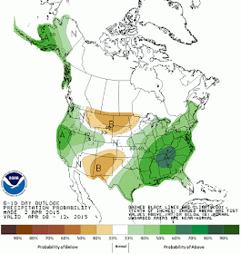
And here is the 6-10 day precipitation forecast by the NOAA Climate Prediction Center...wetter than normal over California!
A modern rainmaker....


Wonderful news. Thanks for posting.
ReplyDeleteLake Shasta gets a lot of water based on the model. But the real watershed for CA is the N Sierra. It looks like that area will be fairly dry.
ReplyDeleteSyphlis,
ReplyDeleteI think you wanted to say the S. Sierras.
http://www.latimes.com/local/lanow/la-me-ln-california-drought-maps-charts-20150401-story.html
. . . and spappyjones,
ReplyDeleteI think you wanted to say Sysiphus.
http://www.thefreedictionary.com/Sysiphus
And Carly Fiorina is blaming the drought on Environmentalists. What sorts of weather modeling does that come from??? ....... Perhaps the Low Pressure Area twixt her ears is affecting rainfall there ?
ReplyDeletehttp://www.huffingtonpost.com/2015/04/06/carly-fiorina-california-drought_n_7014468.html