August 31, 2017

Global Warming and Hurricane Harvey

It is more than a little disturbing.

Before the rains had ended, dozens of media outlets had published stories suggesting that global warming forced by humans (mainly by emissions of CO2 into the atmosphere) played a significant role in producing the heavy rainfall and resulting flooding associated with Hurricane Harvey.


Most of the stories were not based on data or any kind of quantitative analysis, but a hand-waving argument that a warming earth will put more water vapor into the atmosphere and thus precipitation will increase.  A few suggesting that a warming atmosphere will cause hurricanes to move more slowly.


This blog will provide a careful analysis of the possible impacts of global warming on Hurricane Harvey.  And the results are clear:  human-induced global warming played an inconsequential role in this disaster.  

Why did Houston Get So Much Rain?

The proximate cause of the disaster is clear: the extreme rainfall was the result of a hurricane/tropical storm that pulled in huge amounts of water vapor off the Gulf of Mexico (and beyond), and which came into the Texas coast and then stalled for days.   All tropical storms/hurricanes bring large amounts of rain during landfall.  What was different here was the stalling and sitting over the same region for days. 

So if you want to explain why this event was so unusual, you must shed light on the lack of motion after landfall of this strong hurricane/tropical storm.

And how much rain?  Here are the 7-day totals around Houston and the general area.   Over 20 inches in the region surrounding Houston (gray color), with the central areas getting 30-50 inches.  An amazing event.


The Global Warming Analysis

Let's analyze the two key questions:
  • Did global warming juice up Hurricane Harvey, producing unusually heavy precipitation?
  • Did global warming cause the storm to stagnate for days?
First, let us examine what we call the thermodynamic effects:  increasing temperatures and moisture.

 As air warms it can "hold" more water vapor, which can lead to heavier precipitation as the air enters a storm and rises.  In fact, more water vapor can also help rev up a storm as well, since when it condense it releases "latent" heat.  

There is a well known relationship between temperature and the maximum amount of moisture air can hold, the Clausius Clapeyron (CC) relationship, which says that air can hold about 7% more water vapor for every 1°C increase in temperature.

It turns out that there is a lot of theoretical and modeling work that suggests that extreme precipitation in storms might increase at roughly the same rate.  So increase the temperature of the air 1C and extreme precipitation might increase as much as 7%.  Keep this number in your head...it will be important.

For the Texas coast, the temperature of the Gulf of Mexico will be critical, because the air that reaches the Texas coast will have passed over the water.

So how much has surface water or air temperature warmed up during the past decades?  One can go to the NASA GISS website and get the surface temperature change over the past 50 years during August.  The Gulf warmed by .5-1 °C between 1967 and 2016.  Pretty modest. Some of this was natural and some of it was forced by mankind.


But what was the SST anomaly (difference from normal) during the period that really counted here: the week before the hurricane. The NOAA sea surface temperature anomaly for August 20 to 26th showed .5 to 1 C warming above normal in the sea surface temperature for the northern Gulf of Mexico.  Less for the southern coast and right off Texas.

What about the air temperatures over the region in the previous days?  Were temperatures warmer than normal?  No...close to normal (white color)

So Hurricane Harvey developed in an environment in which temperatures were near normal in the atmosphere and slightly above normal in the Gulf.    The clear implication: global warming could not have contributed very much to the storm.

OK, let me go out on a limb. Let us assume that all of the .5C warming of the Gulf was due to human-caused global warming.  That NONE of it was natural.  And that the air was warmed by the same amount. Using the scaling described above implies an increase of 3.5% in the extreme precipitation of this storm.  So for places that received 30 inches, perhaps 1 inch resulted from global warming. Not much.  Immaterial regarding impacts or anything else.

Well, some of you might ask.  Is there any evidence of global warming producing heavier precipitation along the Texas coast?   Surely, if warming was evident and it was significant, precipitation would be increasing over time!

Well, here is the July to October (hurricane season) precipitation for the coast around Houston for the past 50 years.    Lots of ups and down but no trend.  In fact, if there is any trend it might be down.


I could show you a lot more, but bottom line in all this is:

There is no evidence that global warming is influencing Texas coastal precipitation in the long term and little evidence that warmer than normal temperatures had any real impact on the precipitation intensity from this storm.

Now, lets examine the second question.   Is there any evidence that global warming caused the storm to slow down?   Some of the media stories had all kinds of hand-waving speculations.  Such as the jet stream would be weakened and become "lazy" due to global warming.

Quite honestly, none of this is supported by observations or models.

The wind pattern that produced the stagnation is shown in the figure below, which shows the zonal (east-west) wind anomaly (difference from normal) at mid-levels in the troposphere (500 hPa) for August 18-25th.  A reasonable level to evaluate the steering flow for the storm.  Note that the zonal winds are more negative than normal (blue colors) over the Gulf, which implies stronger flow from the east (the convention is that winds going west to east are positive).   In contrast, there are greens and yellows over central Texas and to the west, implying more westerly (from the west winds), which would tend to slow the storm down.  So the large scale flow might accelerate the storm towards the coast and then slow it down.
But do we expect global warming to produce such a pattern of anomalous winds wind over the Gulf?  Are some of the media and "activist" scientists correct in saying that winds over the Gulf will slow down under global warming?   Let's find out.

First, let me show you the change in zonal winds over the Gulf of Mexico for the past 50 years at 500 hPa.  No real trend.   Other levels showed the same thing.


Tom Hamill, a scientist at NOAA ESRL, plotted the average hurricane speed in the region (20-30N, 50-100W), which I show below.  He also shows  (wisely) the number of samples (hurricanes) each year, since the reliability of the average declines when there are few samples.  It is clear that there is little trend, particularly when one only considers the years with decent samples.

Let me stress that it is the trend over the entire period that would suggest an impact of global warming, NOT some transient change over a few years.


What about the future?   Atmospheric scientists run global climate models driven by increasing CO2, with a large collection of runs being available (the CMIP5 effort with around two dozen models).   I did a paper with Matt Brewer analyzing these models (published in the peer-reviewed Journal of Climate) and below is figure from it, which shows the difference in the zonal (east-west) wind  at 500 hPa between the late 20th and 21st centuries for July and August.   Little change over the Gulf and that is AT THE END of the 21st century.  Little would change now.

 The bottom line in this analysis is that both observations of the past decades and models looking forward to the future do not suggest that one can explain the heavy rains of Harvey by global warming, and folks that are suggesting it are poorly informing the public and decision makers.

They are using hand-waving arguments to push an agenda, which observations, theory, and modeling show to be incorrect.  Global warming is a serious issue and mankind must deal with it, but hype and exaggeration of the current effects is counterproductive in the long term.

By the end of the century, increasing atmospheric moisture will increase the intensity of heavy rain in many locations, including the Northwest.   Although there is no evidence of increased hurricane frequency during the past several decades, some studies suggest enhancement of the number of the strongest hurricanes by the end of the century.

One does not need global warming to explain extreme weather--sometimes the factors come together to produce an unusual event... think of it as a meteorological royal flush.


What the media SHOULD be discussing is the lack of resilience of our infrastructure to CURRENT extreme weather.   Houston has had multiple floods the past few years and poor planning is a major issue.  When you put massive amounts of concrete and buildings over an historical swamp, water problems will occur if drainage and water storage is not engineered from the start.

China may be ahead of us in such planning, with a huge investment in their sponge cities program in which they are investing hundreds of billions of dollars.  Blaming global warming makes it easier to neglect the infrastructure investments that are required to protect our cites.

Can you imagine if President Trump announced an infrastructure program to make our nation more resilient to CURRENT extreme weather?   A bipartisan effort to deal with extreme winds, flooding, rain, drought, and other severe weather?


August 29, 2017

Smoke Returns and More Warm, Dry Weather Ahead

Smoke has returned in a big way over Washington State. Yesterday's (Monday) MODIS satellite image showed large amounts of smoke moving northward from large fires in SW Oregon and NW California and local fires over the eastern slopes of the Cascades are making things worse.


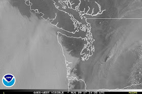
The visible satellite image this morning at 7:30 AM really shows the plume of smoke, which is worse south and east of Seattle. (Low clouds are along the coast).


A close up view really highlights a plume of smoke emanating form a fire over the central Cascades, which is topped by a pyrocumulus cloud that is clearly casting a shadow.


This cloud cloud and associated plume were substantial enough to produce a distinct echo 


The latest MODIS satellite photo shows the impressive nature of two Washington State fires.  Wow.


Visibility has really gotten bad in parts of the Cascades...here is an image this morning from Crystal Mountain, which is not offering crystal-clear skies


And the denser smoke to the east of Seattle was evident in this sunrise shot looking towards the Cascades from the Space Needle panocam.


The smoke unfortunately has mixed down to lower levels over western WA and the air quality has declined substantially in Seattle (see graphic from Puget Sound Clean Air Agency).


The regional air quality situation is scary (green good, red bad, purple means you better not breathe). Much of western Oregon has very poor air quality.


On the positive side, the smoke is reducing temperatures, as shown by this plot of solar radiation at the UW.  Yesterday, the solar radiation was reduced by roughly 13%.  Did you notice the strange yellow/reddish cast to the light?


The latest Canadian smoke model forecast suggests that increasing onshore flow tomorrow should blow a lot of the smoke eastward, improving conditions over Western WA.

Tomorrow (Wed) there will be a mini-marine push of cool, ocean air as an upper-level trough comes through (see map).

But this will bring only temporary relief as ANOTHER ridge of high pressure moves in (see forecast for Friday).


August 27, 2017

How Will Human-Forced Climate Change Affect the Pacific Northwest?

It is an issue of extreme interest to almost everyone:  how will human-forced climate change affect our region?  

This blog will review what I believe is the state-of-the-science, one that will avoid hype or politicization of the issue.  One based on peer-reviewed publications and the best models we have available.  And an analysis that will be honest about what we don't know and the uncertainties.

What Climate Changes Have Occurred During the Past Decades in the Pacific Northwest?

Mankind has already changed the surface climate in our region in profound ways. We have massively irrigated parts of eastern Washington, reducing summer temperatures there (2-5F).   A high resolution satellite image illustrates the vast irrigated areas in the Columbia Basin.


We have cut down the trees in western Washington, replacing them with concrete and buildings, substantially warming the surface (as much as 5-10F, see satellite based temperatures below). Thus, there are urban heat islands in our built up area, with enhanced local temperatures.


We have created large farms in eastern WA, tearing off the protective surface vegetation, resulting in dust storms.  And our mismanagement of eastern Washington forests have resulted in increasing large fires and major smoke outbreaks.

There is more, but the message is clear: human activities have profoundly changed our surface climate in limited areas, without even talking about greenhouse gases in the atmosphere.

What do surface weather observations show, regarding changes in temperature and precipitation over our region during the past decades?  Is there a trend?

Here are plots of NOAA/NWS average temperatures over Washington State for January through June for the past 50 years from their climate division data set (I chose a half year so 2017 could be available). For temperature, there was a big spike in 2015 and a secondary one in 1994, but the overall trend is small, with perhaps a degree of warming for the entire period and little trend since  the late 1970s . Most of the increase occurred abruptly in the late 1970s, associated with shift in the Pacific Decadal Oscillation (PDO), which is a mode of natural variability.  And there was some impact of urbanization.


Precipitation over the State shows little trend, with lots of transient up and downs.

And a plot of the Palmer Drought Index (which includes precipitation and temperature) shows little change.

Regional snow pack on April 1 (right before the big spring melting season) has shown little trend during the past 40 years.

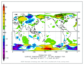
The bottom line is that there has been little change in our regional climate over the past half century.  This is in contrast to other regions (like the Arctic and continental interiors). One reason for our static situation is the vast Pacific Ocean, which has not warmed up much during the past 50+ years.   This graphic of surface temperature changes over the past 70 years illustrates this.


Our Future Climate

But what about the future?  There has been an increasingly rapid upward trend in greenhouse gases (CO2, methane, water vapor), with human-caused increases in CO2 being the dominant forcing agent.  The science is clear:  increasing greenhouse gases will warm the planet--but there are a lot of nuances and details that are critical.

Mankind has done little to stop the increase in CO2, with a fast upward trend in renewable energy being overwhelmed by surging use of coal, oil, and natural gas (see plot of CO2).  Carbon-free nuclear energy is being rejected.  CO2 concentrations are actually rising more quickly today than decades earlier.
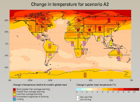
Basic science tells us that increasing CO2 will warm the planet, but that warming is not and will not be uniform for many reasons.  Advanced global climate models (GCMs) allow us to simulate the expected warming distributions..and most of such models (there are about 2 dozen) provide a generally similar geographical distribution (see a forecast for 2100 for an average of several of them, assuming CO2 will keep on going up at roughly the current rate is has been)


The Arctic warms up more than anyplace else (due to melting polar snow/ice and some subtle radiative effects).  The continents warm up more than the oceans (the oceans have huge thermal mass that take time to warm), and the eastern oceans typically warm up more slowly than western oceans.  The Northwest, downstream of an eastern Ocean, thus will warm up more slowly than most.

Although the global climate models are our most powerful tools for looking forward, they are major issues.  First, we have to assume how much CO2 and other gases will be in the atmosphere later in the century.  Second, they lack the resolution to get our local climate correct.  As shown below (the terrain from the NCAR climate model, CCSM4), the current generation of global models don't have the Cascades, Olympics and other critical geographical features that dominate our local climate.


Third, the climate models have major disagreements in regional areas.  In a classic paper, Deser et al., 2012  (Nature Climate Change) ran an ensemble of 40 climate simulations, starting each slightly differently to simulate trends through 2060.  The results for the temperatures at Seattle (see below) varied greatly, with a few runs showing no warming and others much more.


Fourth, many of the global climate models have serious flaws.  Some can not realistically duplicate the current climate (e.g., double Intertropical Convergence Zones, serious biases, severe problems with organized tropical convection).  And some climate scientists believe that the "tuning" to match the 20th century climate makes them overly sensitive to increasing CO2.    There is a lot of dirty laundry in the climate modeling business that the general media and others are not aware of.  Our current generation of forecast models can not predict seasonal changes with any skill...this is a major warning.

So what do we do?  The roughly 2-dozen  global models are the best tools we have.   Society desperately needs guidance regarding the local impacts of climate change driven by increasing greenhouse gases.

So why not start with the best ones (the ones that match contemporary climate the best) and see what changes they have in common.  And we can use the best models to figure out the local impacts by running high-resolution regional climate models that are embedded and nested in the global models.  And when we do this, we have to be totally honest about uncertainties and limitations.

Let me show an example of such a regional climate model simulation for this century for the Pacific Northwest.  And be prepared to be shocked.

 Let's start with surface temperature (2-m temperature) for winter (DJF) assuming mankind keeps on its current track of greenhouse gas increases (a pretty good bet at this point)  The change between the 1990s and 2020s is small, with all warming, but not many locations doing so by more than 3F.

 Between 1990s and 2050s?  More warming, with bands of greater increases.
 2090s?  Yikes...a different world, with some places warmer by 6-8F.
 Why the bands of greater warming?  That is where we are losing snow at lower elevations.  Snow reflects solar radiation, so a loss of snow really revs up the heating.  You need a high-resolution model to see this effect.

A key issue is that warming is not uniform in time.  The warming is slow at first (aided by the slow to warm Pacific), but by the end of the century it really revs up.   Another way to see this is a plot of the number of days per decade above 90F at Sea Tac Airport.

Not much change in the 2020s, up a bit in 2050, and BIG increases during the late 2090s.  For all of you under 40, you should make a note to yourself to buy an air conditioner in 2050.  Maybe two.
I can't stress this enough.... the big changes due to human-caused global warming in the Northwest are AHEAD of us. 

The current NW climate has been relatively unchanged so far.    But saying this has gotten me in total trouble with some local climate advocates, who call me all kinds of names for talking about this "inconvenient truth."  I mean really nasty stuff, like being a "denier", a "contrarian", "dangerous", "losing my mind", and lately being sympathetic to "white supremacists".  You deserve the truth, not manipulation, and exaggeration to ensure "you do the right thing".

What about precipitation in our region?  Most simulations, either based on global climate models or their regional "downscaled" versions indicate that there will be a small increase (5-10%) in regional precipitation (changes over Puget Sound are shown below).

We will retain our water as the earth warms.  This makes sense, a warmer atmosphere can "hold" more water, so our precipitation will be juiced up.


But occasionally, it may be juiced up more than we like.  The latest simulations suggest that atmospheric rivers---plumes of water vapor coming out of the tropics/subtropics--will get substantially enhanced by global warming, and our extreme precipitation events during such rivers could be 30-40% stronger by the end of the century.

The number of heavy precipitation events will increase dramatically, particularly during the fall (see graphic below showing changes in the number of event between the ends of the 20th and 21st century).

With a big increase in heavy precipitation events, flooding on our major rivers will increase.  We will need to deal with this, pulling folks away from such waterways.   And yes, not allowing people form living on or near slopes where slope failures could endanger them (e.g., Oso).

As our region warms, the snow level will rise in the mountains, with much more precipitation falling as rain in the middle elevations, where previously there had been snow.  We will have less snow in our mountains during the winter and there will be less snowpack on April 1, leaving less snow melt to provide water during the summer and autumn before the rains return.

The predicted change of snow pack by the end of the century is substantial, with losses (red colors) exceeding 40% in some locations. (see graphic)


So what do we do with water in late summer, as snowmelt lessens?   Since our annual precipitation will increase, the water will be there, so we may need additional reservoir capacity in some locations.   Fortunately, the critical Columbia River drainage may be in relatively good shape because it drains off the very high Rockies, where there will still be a lot of snow, and because of the huge storage capacity behind all the hydroelectric dams.

Thus lack of snow will have another negative impact: snow absorbs water during heavy rain events, so less snow means less buffering of the rain, contributing to flooding, particularly during the fall.  Seriously, I would not want to live in the flood plains of our local major rivers.

What about windstorms caused by big midlatitude cyclones?    The media keeps on talking about how they will get worse around here.  Fortunately, the best climate simulations  do NOT suggest this...our storms will be relatively unchanged (see graphic below that was produced for Seattle City Light).

Number of times per year above the 90 percentile wind speed for 1970-2000 (DJF)

The lack of change of windstorms makes sense.  Our wind storms are driven by north-south temperatures differences and those will weaken at low levels under global warming (polar regions preferentially warm compared to the tropics in the lower atmosphere).

And our computer models indicate all kinds of unexpected changes in our region with global warming.  For example, the amount of low clouds in the late spring and early summer may increase, as the greater heating inland causes preferential pressure falls that draw in cool, cloudy marine air (see graphic).  Super June gloom powered by global warming.  That will send come Californians back to where they came from!
And in a warming world, the strength of summer disturbances and easterly offshore flow may weaken, taking the edge of western Washington heat waves.

And, dare I say something that will get me in terrible trouble with certain folks?  As described in the peer-reviewed literature, warming will have some positive impacts as well, including a more pleasant climate for much of the year, less black ice on the roads, less exposure deaths of homeless folks, improved air quality during the winter, among others.

Enough.   I wanted all of you to be exposed to a description of the current science not provided by some local media outlets, a few of which are providing a highly skewed, inaccurate view of what is expected.    Some of outlets (e.g., Seatttlle's The Stranger) have descending into exaggeration, advocacy, and name calling, as have a few "advocate scientists.".  

Society can only make good decisions only if it is given the best estimates our science can provide, and hype/exaggeration/and worse is destructive on many levels.    Imagine planning a new reservoir based on exaggerated predictions!  Exaggeration and hype also lead to politicization of dealing with climate change, which ensure progress is restrained.

Finally, let me note that understanding the local implications of climate change is an act in progress. 

As I will describe in a future blog, several of us are trying to get better answers by running an ensemble of many high-resolution local climate simulations to get at the uncertainties and possibilities.   Other atmospheric scientists (some in my department at the UW) are working on improving the global models.  Others, such at the UW Climate Impacts Groups, are trying to translate the model predictions into societal implications.

There is much work to be done: in understanding the local implications of climate change, taking steps to prepare our region for what will occur, and to do what we can to lessen emissions of carbon around the world.


August 25, 2017

Extraordinary Radar Imagery for Hurricane Harvey

The importance of having weather radars along our coasts is highlighted by the amazing imagery from the NWS radars at Brownsville and Corpus Cristi.

Here is one at 6:44 AM PDT this morning. The circular eye of Hurricane Harvey is obvious.   Look closely and you will see evidence of a double eye.  This often occurs as a hurricane goes through a eyewall replacement cycle, in which an exterior eyewall develops and then shrinks in radius and intensifies.   Storm often strengthen as the outer eye wall  tightens inward around the low center.


With coastal radars, hurricanes (and other storms) can be examined comprehensively as they approach land.  They are in fact, the CAT scans or MRIs of the meteorological profession.    The importance of such coastal radars is why many of us pushed for a radar on the Washington coast at Langley Hill and why folks in Oregon are pushing for a radar on the Oregon coast---the last great gap in U.S. coastal radar coverage.  The central pressure of Hurricane Harvey is about 950 hPa.   The Columbus Day Storm of 1962 was similar:   955 hPa.

Our ability to follow hurricanes is not limited to weather radar.  Improving satellite imagery, such as from GOES-16, provides amazing views from space (see below).  You can even see a very small hurricane eye.

And during the last few days Air Force and NOAA aircraft have been traveling in the storm, taking flight level observations and dropping instrumented packages called dropsondes.   Here is a graphic that show the winds at flight level from an aircraft now in the storm.


We can no longer be surprised by approaching coastal storms or hurricanes with all these assets.  But our models are still inadequate for predicting variations in intensity and there is some research suggesting that intensity prediction more than a day out may not be possible....we will see.

Current model runs are unanimous that Harvey will strike the south/central Texas coast later today and that there will be a huge amount of rain.  They disagree about intensity and subsequent path (see below).  But nearly all suggest at least a CAT 2-3 storm, with max winds exceeding 110 mph.