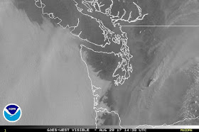
Smoke has returned in a big way over Washington State. Yesterday's (Monday) MODIS satellite image showed large amounts of smoke moving northward from large fires in SW Oregon and NW California and local fires over the eastern slopes of the Cascades are making things worse.
The visible satellite image this morning at 7:30 AM really shows the plume of smoke, which is worse south and east of Seattle. (Low clouds are along the coast).

A close up view really highlights a plume of smoke emanating form a fire over the central Cascades, which is topped by a pyrocumulus cloud that is clearly casting a shadow.

This cloud cloud and associated plume were substantial enough to produce a distinct echo
The latest MODIS satellite photo shows the impressive nature of two Washington State fires. Wow.
Visibility has really gotten bad in parts of the Cascades...here is an image this morning from Crystal Mountain, which is not offering crystal-clear skies

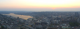
And the denser smoke to the east of Seattle was evident in this sunrise shot looking towards the Cascades from the Space Needle panocam.
The smoke unfortunately has mixed down to lower levels over western WA and the air quality has declined substantially in Seattle (see graphic from Puget Sound Clean Air Agency).
The regional air quality situation is scary (green good, red bad, purple means you better not breathe). Much of western Oregon has very poor air quality.

On the positive side, the smoke is reducing temperatures, as shown by this plot of solar radiation at the UW. Yesterday, the solar radiation was reduced by roughly 13%. Did you notice the strange yellow/reddish cast to the light?
Tomorrow (Wed) there will be a mini-marine push of cool, ocean air as an upper-level trough comes through (see map).
But this will bring only temporary relief as ANOTHER ridge of high pressure moves in (see forecast for Friday).


Okay. Soooooooo is there any rain on the horizon? Too much of a "good thing"...warm, sunny, dry weather.
ReplyDeleteMy thoughts exactly.
DeleteIs the air pressure and flow here affected by the hurricane and tropical storm on the Gulf coast?
ReplyDeleteHello Cliff. It seem like the Pacific ridge of high pressure has been much stronger than normal during the last 5-7 years. Do we have information to verify? Are there any know causes or concerns that this may be trend that continues?
ReplyDeleteIt feels more humid and muggy when we have smoke around, but I don't know why that would be. Is there any truth to that, or am I making it up?
ReplyDeleteI second what evie says. Yes, sunshine is good, but let's have a wetting down. I'm sure the Texans would be delighted to give us some of all that rain- if only they could!
ReplyDeleteI can almost here the weather app chime going off with a "first rain/wind storm of the season alert. Pumpkin pie. The corn maze, hot spiced ciders.
ReplyDeleteNow you're talking!!!
DeleteCliff, I for one really appreciate your posts. Energetic people like you who enjoy sharing valuable information and educating in a fun, informal manner are one of the things that make me all warm and fuzzy. Keep it up!!!
ReplyDeleteWill it ever rain again in the Seattle area until maybe October or November?
ReplyDeleteWe've had around 70+ days with no rain, discounting the paltry .002 in. of "mist" at the SeaTac airport earlier.
My garden water bill is assume.
John Gowdy
john@thegowdys.com
Drip system playa
DeleteWe had such an amazing spring with the rain and literally no rain this summer. Yet another heat wave coming in. Will this nightmare end?
ReplyDeleteThanks Cliff. I'm soooooo tired of this summer. Can't we get say 2% of the rain Houston is getting? While there was lots of smoke in the sky above Winthrop it really hasn't mixed down yet so the air is still breathable. I'm sure glad the eclipse was a week ago.
ReplyDeleteIf I'm reading the model charts correctly, the GFS shows the westerlies breaking through this stubborn ridge and pushing the first significant rain-producing system into PNW by about 9/10 or 9/11. The usual problems with convective feedback in the GFS also ramp up around that time - but the Euro is at least hinting at the same thing by showing a deep trough digging south and east out of the GOF by next Wednesday.
ReplyDeleteThe GFS is always prone to exaggeration when you get more than about 7 days out, but at least the Euro isn't saying anything to the contrary (yet).
Yep, most models are accurate that far into the future. In the desert at least...
DeleteYa I notice that the GFS has been showing a pattern change out after around 10 days in some runs, than in other runs it's back to the same- big ridge, highly amplified pattern. It's a model mirage! There is alot of energy in the North pacific as parts of the Alaskan panhandle and the northern coast of British Columbia have seen alot of rain since around mid August. Well over 8 inches at Prince Rupert about 400 miles north of Vancouver. We often break a drought with an atmospheric river and if the long wave pattern remains amplified and the ridge retrogrades than we might see some of the energy that is currently pounding northern British Columbia move South. This time of year is always a bit of a crapshoot with the models beyond 7 days as a changing season and the added dynamics of additional energy in the North Pacific (like extropical typhoon energy) often throws the medium range models out of whack a little.
DeleteCheck out the color imagery from GOES-R. Really a much better source than the black and white goes-west images.
ReplyDeletehttp://news.stanford.edu/news/2014/september/drought-climate-change-092914.html
ReplyDeleteThis article seems to talk about CO2 forcing potentially causing increased amount of high pressure ridges - AKA 'blobs' like we've been experiencing since 2015.
CO2 only forces more plants to turn green, since it is natural plant food. On the other hand, HAARP forces hurricanes to strengthen unnaturally quickly and then stay in the same place, also unnaturally. You do the math.
DeleteSince 2015 we have seen two of the wettest fall and winter periods on record and also the wettest spring this year. The blob caused by persistent high pressure (the dry fall and winter) was in 2013-2014 and was likely just natural variability that caused it.
DeleteThis summer has jumped the shark. As someone who makes their living working outdoors, seeing 90's in the forecast yet again is obnoxious.
ReplyDeleteIn retrospective thus far, with August removed from the equation, it would have been a perfect summer. It has been a really miserable month, and of course that is being said carefully with a certain degree of empathy and humility. Texas would probably gladly take a few weeks of toxic air and excessive heat in trade for Harvey.
just looked at the forecast for next week...we might break 100 out on the eastside! what a great summer!!! hope this extends well into October.
ReplyDeleterain lovers need not worry. it will be back. reservoir levels are very good right now. I'd advise you all to crack one open and enjoy the sun while it's still here.
For a morning when no rain was forecast, even in the 3am forecast, there's an awful lot of wet out there.
ReplyDeleteIf you want continued hot weather joe, just move! The PNW landscape is not conducive to this extended heat and dryness. Would you prefer the whole Cascades go up in smoke while you "enjoy it with another beer"?
ReplyDeleteCliff, while I enjoy your posts, sometimes it would be nice to see some responses to some of the questions posted by others. I realize you must be busy, but........
We have had hot and dry summers many times in the past but at least there was usually a little rain and maybe a few days in between the hot spells thst are cooler and troughier. This summer barely any relief. As far as hot summers go I don't think this one holds a candle to 2015. Even 2009 seemed hotter to me. There is still alot of water in the reservoirs due to the wet winter and spring and high snowpack. The pattern will change it always does. I just hope we don't have drought like conditions into October and November which we saw in 2012, 2002 and was actually much more common in the 80s and early 90s.
ReplyDeletewhy should I move, Snoqualmie joe? the weather's great! we seem to have it all lately...wonderful summers for people who actually enjoy sunshine and warm temps, and long wet winters for those who don't.
ReplyDeleteI think you're being a bit hyperbolic with the "whole cascades going up in smoke" bit. yes, there are some fires, but nothing out of the ordinary.
joe mama- the trees in the forest can't go get a drink from the reservoir. At some point some of them will die due to the hot/dry conditions. Here in south King County I already see lots of dead trees from summer of 2015. This month several trees already have their fall colors and are dropping leaves. They're stressed. Maybe you could go area beer with them. ;)
Delete*share a beer
Deleteok, fine, don't crack open a beer and enjoy the weather. continue to complain about it on this blog. that will get you a whole lot of nothing.
ReplyDeletethe inability of pacific northwesterners to roll with the punches never ceases to amuse me.
It is not so much a lack of rolling with the punches. More like a lack of air conditioning. Typically most people who "love" smothering hot weather have the means of escaping it when the novelty wears off. AC at home/work/car. A pool. Quick trip to a beach or lake. A boat. Etc. When you don't access to those amenities, heat waves are misery at the very least. For some its death. One stupid beer doesn't go far enough.
ReplyDeleteEven all the worshipers of all that is hot and sunny in Arizona know when to stay out of it. People who chose to live in places like Florida and Arizona decided on that compromise because they hate the cold weather more than the hot. Hiding inside when its 115 degrees outside is considered a fair price of doing business to them; the reward of course is the bulk of the time when it is comfortable.
So unless you really enjoy sweating, body odor, sun burns, basting awake in your own bed knowing you have to face the next day of more of the same along with all your irritated fellow humans, than give people in the PNW a pass. Many live here because our idea of (a brief) summer is 75-80 with a nice breeze and cool evenings. One hot week is permissible, but that's IT. Not 95+ with Beijing smoke. There are much, MUCH cheaper places to live than here if you want hot and miserable.
Very well said. Now maybe Mr. Mama can put a sock in it.
DeleteI DID put a sock in it. It being my hiking boot. Got some miles in, picked some berries, made a pie, cracked open a brew when I got back to the car, and another when I got back to my (non air conditioned) home.
ReplyDeleteAnyone who tries to compare our current "heat wave" to Arizona automatically loses the argument (unless you're talking about the high country, which is quite pleasant). Relax, guys, the big bad "heat wave" will be gone soon enough and you'll have your wonderful wet blanket to snuggle up with.
Until then...Hike. Bike. Pie. Beer. Lather, Rinse, Repeat.