The first step in this event was the push of northerly winds into the region, particularly east of the Cascade crest. As strong northerlies entered northeast Washington, the Cold Spring Fire began south of Omak. It went from zero to around 10,000 acres with a few hours and the smoke from it extends southward across eastern Washington (see image, arrow points to fire)
The initiation and growth of the fire was evident on infrared satellite imagery (see below). The dark area indicate the warmth caused by the fire. The first image was around 11 AM, the last image at 8 AM this morning.
A blog reader near Electron, Washington took a picture this morning (see below). Evacuations are underway right now around Cameron Lakes.
The Current Winds
If you are in the central Puget Sound region, you will note something strange is going on---strong winds from the north in the morning. In eastern WA the northerly winds are powerful. Here are the winds across the region at 9AM (click on image to enlarge). The black numbers is temperature, the red ones provide wind dusts. The wind barbs give direction and speed.
Northerly winds are gusting to as high as 48 mph in eastern Washington. No wonder that fire is spreading quickly. And gusting to 20-30 mph in parts of western Washington.
But the real dangers are ahead. The strong northerly winds will push south, driven by high pressure extending southward east of the Cascade crest. This in turn will force powerful easterly (from the east winds) over the western side of the Cascades, particularly south of Seattle. Over NW Oregon, such easterly winds will be extreme, gusting to 50-70 mph in locations. THIS is what might cause big west-side fires if there is ignition.
Below are the latest UW WRF model wind forecasts (sustained winds, not gusts).
11 AM this morning, very windy over eastern WA.
By 5 AM, the easterly winds reach the southwest WA and NW Oregon.
And at 11 PM tonight, strong easterly winds are apparent over the western slopes of the western slopes of the WA Cascades. This is the most dangerous period.
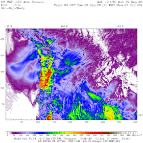
Finally, here is the USDA Forest Service Hot-Dry-Windy index at 8 PM tonight, which considers both wind speed and the potential for evaporation (which dries fuels). Red hot over NW Oregon. A very dangerous situation. It is up to all of us to prevent a fire by denying any source of ignition.
___________
KNKX surrenders to cancel culture. More information here.
_____
My Patreon site:


This comment has been removed by a blog administrator.
ReplyDeleteI'm sure that the nightly riots here will be suspended because of this dire fire warning, and that their daily habit of lodging molotov cocktails at the police and other incendiary devices will be suspended, at least for one night. Yeah, and then hell froze over.
ReplyDeleteOur AQI in Tri-Cities is currently 616 and a thin layer of ash has already accumulated. Visibility is not quite as bad as the BC fires event 2 years ago when the AQI never went this high, presumably because of a difference in the size of the smoke particles in fresh vs. aged plumes. The situation in Mansfield south of the fire sounds quite extreme.
ReplyDeleteThe most likely cause of fire ignition will be one that is human caused, yet uncontrollable- downed power lines.
ReplyDeleteI worryabout all the encroachments we’ve made into the wildland over the past 25 years, southeast of Bellevue and in Issaquah, Sammamish, and Snoqualmie
ReplyDeleteFraser Gap Winds fierce in Western Whatcom County. Blowing 35-40 guat. Hunidity down to about 27%
ReplyDeleteFantastic info Cliff. *Thank you* for this. Some scary stuff indeed...
ReplyDeleteJust like Santa Ana winds. Wonder if it will become a more regular feature of the weather here.
ReplyDelete