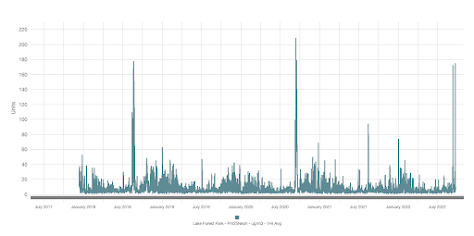
Here in Seattle, the smoke was amazingly thick on Wednesday morning, only exceeded by the extreme event of Sept. 2020 and equaled by the smoky period in summer 2018 (see small particle levels at Lake Forest Park over the last 5 years ago).
The intense smoke was associated with a dying fire (Bolt Creek) in the Skykomish Valley.
How could this be?
The explanation is found in my podcast (see below). The "perfect storm" of meteorological conditions.
And talking of perfect, consider the weather conditions over the Northwest this weekend.
ANOTHER ridge of high pressure will develop over the West Coast this weekend (see upper level map , 500 hPa--about 18,000 ft late Sunday below). And you know what that means.... warmth and sun.

But this time of the year we can't get really hot...so highs will only get into the upper 70s in the west. Nearly perfect. It won't last though...cooler temperates for mid-week, but little rain in the forecast. My podcast goes into the details.
To listen to my podcast, use the link below or access it through your favorite podcast service.
Some major podcast servers:
Like the podcast? Support on Patreon

I note that most years, the first promise of rain falls flat on its face more often that not. This has happened twice this month so far.
ReplyDeleteDriest summer on record. And way too hot nearly all summer. Now more dry, warm days into fall. This is getting old fast. Where is the rain?!?!
ReplyDeleteSimmer down Steve, I'm not sure if you've been paying attention, but we get plenty of rain around here. I guess it's a lot to ask for you to suffer through two or two and a half months with hardly any rain while the rest of us rejoice. Must be excruciating for you.
DeleteSteve, don't know about you but it's been a delayed summer, so a delayed fall like weather, usually.
DeleteI grew up here and I don't think we have had it terribly hot. While anything above 80 is considered hot for this area, at least during the day, and the overnight lows have been a tad warm, but even this is nothing like 2019 where the overnight lows were often in the mid 60's with very high humidity, thanks to the Blob, but the daytime highs were not much above normal then, same here now. If the Weather Channel is anything to go by, they are saying several days next week, we may see some light showers. Typically, the real rains don't come until October anyway. The extra dryness was due to the winds that blow from the East, but only occurs most during Sept anyway. Summers are typically dry around here to begin with.
That said, the Weather Channel is saying 72 today, but Cliff is saying upper 70's if not mistaken. That all said, I just don't think it's too out of the ordinary for this area, this time of the year, even if our spring was wetter than usual until July.
I like the sun too, don't get me wrong, and I'm one of the first to visit the beach in spring. But when we go more than two months without rain I start to miss it. My East Coast imprinting, I guess. This climate has been called changeable, but nothing could be further from the truth. It gets "stuck" in one mode or the other.
ReplyDeleteI seem to notice that when summer starts late, it tends to run late. True?
in re Tonga January 10% stratospheric moisture increase: were Australian and European
ReplyDeleteI'm not sure I agree that we're in meteorological Fall: Freezing levels 13,000 feet or higher; offshore flow upcoming again, no sign of any "vigorous" weather system as they say on NOAA, and temps still in the upper 70's... Yes, the days are getting shorter, the sun lower, but I think we are still in meteorological summer...
ReplyDelete