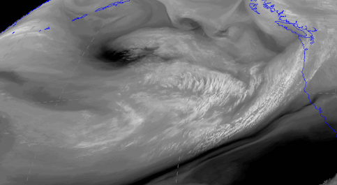
The latest water-vapor channel satellite image is quite ominous, with a series of very wet weather systems approaching our region.
The weakest of the bunch is starting to come onshore right now (on Saturday), but early next week will be seriously wet.
Let me show you.
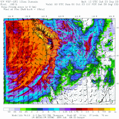
The 72h total precipitation through 5 AM Tuesday, will make any duck happy (below_. 3-5 inches in the Olympics and even more over the mountains of southwest BC. Substantial precipitation in the Cascades and large amounts over SW Oregon and NW California.
But if you really want to be shocked by nature's wet bounty, check out the one-week totals ending at 5 PM next Saturday. Wow. Western Washington, BC, and Oregon are hit hard, with some parts of the Olympics getting nearly 10 inches of rain.
The wildfire season will be over for the year folks...you can count on that.
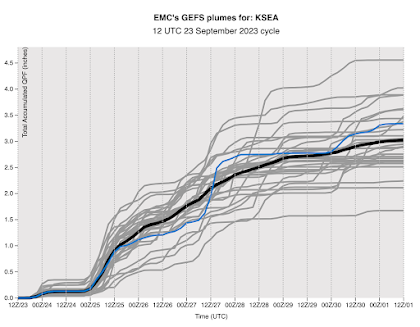
All state-of-science weather forecasters use ensembles of many forecasts to gain an idea of the uncertainty of the forecasts. So below is the ensemble prediction of accumulating precipitation from the NOAA/NWS GEFS ensemble for Seattle. Each gray line is one forecast, the blue line is the high-resolution prediction, the black line is the average of all the forecasts, and time increases to the right.
All forecasts are going for heavy precipitation, with an average of around 3 inches in Seattle for the next week.
Rivers will rise rapidly, reservoirs will begin to refill, and you can forget about watering your lawn, outside plants, or anything else. September rainfall in 2023 will come in around double the normal amount (which is about 1.6 inches). In fact, this rainfall will ensure that our July-August-September totals are near normal (3.1 inches).
Disturbingly, considering this forecast of heavy rain, some unfathomable warnings and actions are taking place in the public sphere.
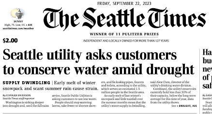
For instance, a few days ago the City of Seattle asked people to use less water, take shorter showers, stop watering their gardens, and other actions, all based on a dry summer and supposed forecasts of continued dry conditions. I wonder where Seattle gets its forecast guidance....the prediction models have been emphatic about a turn to wet conditions for the last week. And this is the time of the year when rain returns.
Of course, the Seattle Times suggested that were are in a serious "drought", with a front page banner article in Friday's paper (see below).
Most of the ST claims are either false or highly exaggerated/deceptive. Let me prove this to you.
Let's start with the snowpack plot from the Seattle Public Utilities website (below). The 2023 snowpack above Seattle's Cedar/Tolt reservoir is shown in red, 2020's amount in green and blue shows the normal situation. Our snowpack this year peaked above normal and later than normal, with the melt DELAYED from normal years. The Seattle Times needs a fact-checker!
What about the reservoir storage, which the ST notes is only at 30% of capacity?
Deceptively, the Seattle Times did not provide the truly relevant number, the current percentage of normal.
Let's look at the reservoir level plot from the City of Seattle (below), showing this year, 2022, and the average.
You will note that reservoir levels are typically lower this time of year....perfectly normal and expected after the typical dry summer around here. After a warm, dry summer we are a bit below normal.
By how much? The average is about 30 million gallons of active storage and this year we are about 26 million gallons. So right now Seattle reservoirs are around 87% (26/30) of normal. Doesn't sound as scary does it. Both the Seattle Times and Seattle Public Utilities should have said this. But they didn't.
And what about the bogeyperson of global warming as the cause of our dry summer?
Completely unsupported. We were dry because of the persistent large-scale weather pattern that made California WET, and such patterns have no connection to global warming.
But I can prove this to you in another way. If global warming was a contributor to drier summers around here you would expect to see a long-term trend toward drier summers, since the earth is already warming from our emissions of greenhouse gases, such as CO2.
Here is a plot of summer rainfall (June-August) for the period of record (1904-2023), with a trend line put on for reference. Yes, the last summer or so has been a bit dry, but the trendline is UP (wetter). And many years were drier than this year. Really little indication of global warming, which should be most evident from roughly 1980 and later.
I know some of you are upset when I note errors and exaggeration in the Seattle Times and other media (and yes some politicians). But a democracy can not function properly if citizens are misinformed and the Seattle Times and others are doing so in a very deliberate, unfortunate way.
A reminder that I am teaching Atmospheric Sciences 101 this quarter.
You can attend in person or online.
I should note that Washington State residents over 60 can take it for a very small charge (like $25) through the ACCESS program.
And I would certainly welcome any UW undergraduate or graduate students.
The class website is here if you want more information.


.png)
The Seattle Times is all in on the global warming hoax. The ST will never acknowledge that the trendlines are flat for precipitation, snow pack and maximum temperatures. They want all of us to freeze in the winter and sweat in the summer because we won't be able to afford the energy to keep us comfortable. But, the ST will never do anything that might impact their operations.
ReplyDeleteThis summer was perfect for tomato growing. Warm but not too hot. This is our first summer in our new house just north of Snoqualmie Falls. I planted 4 Oregon Spring plants and we've gotten about 10-15 lbs. of tomatoes from each plant. A fabulous harvest! It helps that the plants get full sun and that there's a waterline nearby.
I appreciate that you provide data to validate your blogs. It does seem odd that there have been 11 consecutive years of below average rainfall. Do you have a explanation for that?
ReplyDeleteNot odd at all....there was a dry period in the 1930s as well. They is substantial natural variability in the system
DeleteAs I said to another commenter a couple of days ago, this dryness is NORMAL for this area. I believe our climate is more meditteranian than anything else. This means mild summers, relatively mild winters most years but dry during the summers, usually and wet during the fall/winter and at least the first half of spring before we begin to dry out for July/August and likely the first half of Sept.
Deletejust a note of thanks (again) to Cliff - really appreciate the forecasts, and the in-depth look at the weather, along with science based facts about our climate. Thank you!
ReplyDeleteMy understanding is that we do, in fact, on average tend to get warmer, dryer fall and winter conditions during el nino events (which appear to be highly likely and fairly strong this year). And maybe that is what SPU was / is concerned about. Honestly I didn't read their website and don't care, but to try to give them the most benefit of the doubt. And it is amusing that we are about to get several inches of rain right after they (and ST) come out with their drought / conserve water message. Part of the reason I live in the PNW is because we have plentiful water and humans use a tiny fraction of water resources here (unlike in the SW, where they will literally run out of water at some point and will likely need to turn to desalination). I always laugh when the media goes on about severe drought and water scare in the PNW. When I drive around during these 'severe droughts' and see large rivers running everywhere and huge lakes full of water, it seems to me we don't have a water availability issue, we have a water planning and management issue. But government officials will never point the finger at themselves for the complete lack of basic foresight and fiscal fortitude to ensure we have adequate water storage and distribution for our population (AND PLANNED POPULATION GROWTH). They'd rather blame the bogeyman......
ReplyDeleteSeattle Times = Yellow Journalism. I quit reading that dirty dish rag two decades ago. Cliff nailed the AR/heavy rain for the PNW forecast on his Sept. 18 blog. NOAA didn't mention the AR in its forecast discussion until Sept. 23.
ReplyDeleteI question your trend line on the June thru August precip. graph that continues rising up through the recent 30 year period. If you divide the total period (1905 to 2023) into three equal periods of about 40 years, the first and last 40-year periods are about equally dry with the middle period ( about 1944 to 1984) being significantly wetter. There seems to be a downward trend the last 30 or 40 years.
ReplyDeleteYup, I moved out here from CT in the 70's, which, as I say, probably gave me a somewhat biased view of our summers toward the wet side. First impressions! But I have enjoyed this warm rain, and don't look forward to the 40 degree rain.
Deletehttps://www.wunderground.com/forecast/KBLI
ReplyDeleteI agree, looks more like showers through the week
ReplyDeleteFirst, as the good physicist said, climate change is not a crisis. Our leaders are creating a crisis, however, by imposing all kinds of taxes and restrictions, putting people into poverty. Impoverished people tend to not have garbage pickup. Prosperous people tend to prefer and preserve their clean water and air.
ReplyDeleteWhatcom County here. We've got water systems west of I-5 that are shipping water in. Same with some private wells. I heard a well maintenance company say that it's often October when they get the phone call about a dry well, even though the weather was wet for the month of September. It can take months for the ground to re-charge. You're the meteorologist, but what happens under ground is a bigger mystery.
Last fall we had dry, dry, dry until December and then we dropped into winter early. When the ground is frozen in the nearby hills the water does not soak in and replenish the ground water. Wells in Whatcom did not get the blessing of our winter water. And then it was cold cold cold until mid-spring this year, and again, some of that melting snow went away before the ground was thawed enough to take it in. And then our summer was dry. I'm seeing several hundred acres of field corn here that went brown before they were harvested. I'll guess they were junior water rights holders and couldn't irrigate when needed, or perhaps those fields are not typically irrigated and the farmer takes whatever the field yields.
It's been a weird 12 months, well, 18 if you count the 2021 flooding, and while nothing is completely out of ordinary, the nexus of little idiosyncrasies has been a problem for many here.
Hi there- also Whatcom resident. The corn fields might look dry but that’s mostly silage and we don’t waste water on high quality corn for cows.
DeleteA little confused here. So, silage is high quality corn for cattle? And dairies don’t need much of that? Is that why they plant and then take whatever the field yields?
DeleteWell, I recall you saying rains are a comin', and they did. It's wet here in Tacoma as I type this. About to slog (drive) to the store for a couple of things and come back to get dinner going.
ReplyDeleteIt's normal, as you say, for the rains to often begin in late September and had seen a YT short from KING 5 about a look at the summer this year, forget some of the details, but they ultimately said, as of now, we are something like -7.2-7.5 inches short. Remember, we still have all of October through the end of the year to add in. Personally, I don't find being 7 inches short all that bad as that's easily recouped by year's end. It did feel rather dry this year, but it didn't feel overly so, and I have lived in the area most of my life as I'm a native of these parts.
As a licensed engineer we always had to sign/seal our work for liability purposes. We could potentially lose everything we own when we provided products and services that were erroneous. If the same were true with our utility managers and reporters, there might be a little more honesty about these matters. Unfortunately, there seems to be no liability and the result is a bit like when the boy cried wolf - I worry that we are coming to a time when few will listen to the "expert" advisors as they seem to push their political visions for the way things should be rather than the way they are.
ReplyDeleteSPU is reporting what they hear from people with decent credentials: the US Drought Monitor program at University of Nebraska reports that much of our state is in extreme or severe drought (link below), and from what I have read El Nino years often produce warm, dry winters (no link...please correct if wrong...I'm no expert). So they felt it was enough of a possibility to encourage an ounce of prevention and ASK people to use less water, in case things go badly. No draconian measures, no big government, just a request: "Hey, this might be a problem later on, so can you use less water so we can give ourselves some more cushion. We don't want to have restrictions, so let's give ourselves some wiggle room." The way you're all reacting, you'd think they asked you to give up your first born male child.
ReplyDeleteI agree that climate change consequences should be backed up by research articles. Many news outlets have knee-jerk reactions on this. But then again, some experts spend a lot more time saying what events aren't proven to be climate change related than talking about actual climate change consequences, so we all have areas for growth.
Drought data: https://droughtmonitor.unl.edu/CurrentMap/StateDroughtMonitor.aspx?WA
Drought Monitor is subjective and deeply flawed.
DeleteI've been a silent reader for a while now, and I really appreciate your work and perspective. You say in a paragraph above, " . . . supposed forecasts of continued dry conditions." My understanding is that you forecasted a warmer drier winter ahead due to the strong El Nino forming, you wrote about it in a previous blog post. Could you clarify? Considering the data for total rainfall from the start of 2023, how much rain do we need to get by the end of this December to be caught up for the whole year? Is "normal" rainfall for Washington usually more than enough in terms of wells and reservoirs being full and irrigation needs being met? Would 'drier' then be somewhat inconsequential in terms of reality on the ground, and more consequential simply for the records? Thank you!
ReplyDeleteHey Cliff,
ReplyDeleteNice name. Long time reader. I had prepped something late winter but deleted it. However today based on the discussion I'll revisit it in summary.
I agree with everything you say about Seattle Times dramatizing things. Them aside there does seem to be something fishy going on with last years SWE charts. Either from our instrumentation or how we measure.
First off it seems some of the data portals in some of my goto snotel sites are down. Do you know somewhere else to get data mountain data from that includes SWE, Snow density, temps, precip, and snow depth? I usually go here
https://www.nrcs.usda.gov/wps/portal/wcc/home/
But its down.
All that aside. I believe there was something strange in how SWE was reported this year. And I see the pattern all across the cascades. In general we received a below average precipitation winter. Nothing major, but noticeable.
https://www.nrcs.usda.gov/Internet/WCIS/AWS_PLOTS/siteCharts/POR/PREC/WA/Olallie%20Meadows.html
We also had a cooler winter, excluding our warm dry spell in January we enjoyed a slightly cooler than average winter. This meant really nice snow for skiing but I was perplexed in how SWE seemed to be telling a different story. One that mimicked ski seasons of past which much deeper thicker snowpacks. By late April I knew it wouldn't take more than 1 good warm spell in May/June to reverse all that. And if you look at your SWE chart we moved considerably above the median, to below over the course of a week in early may. And in fact I remember that shift as it all happened in a few short warm days early May. In my mind the SWE was not high. We had a nice consolidated lighter and drier snowpack. Not quite continental, but less maritime than we are used to. And I knew the first big heat event would reveal the truth.
My question is why didn't the SWE charts track in-concert with the temperature/precipitation charts. Where in general a cooler drier year I expect less SWE, not more.
Hey Cliff. A while ago I worked on local reservoir modeling for climate change, and found that we had enough water for people, but the required fish flows in the fall could cause issues with the water supply if the fall rains didn't materialize. We would specifically decrease our hydropower generation in the late summer specifically so that we could ensure that we had water for later in the year for the FERC mandated water flows for fish spawning.
ReplyDeleteHave you spoken with any dam operators on water release needs from the reservoir systems and how that plays into the desire to conserve? Systems are complicated, and discussions with other fields may help one understand the suite of issues at play.