In the Northwest, October is the transition month to the wet, winter regime that extends through mid-February. And the next few weeks should reflect the typical changes.
But before I show you the latest forecasts, let's look at the typical precipitation of climatology at Seattle.
The figure below shows the climatological probability of getting at least 0.01 inch of precipitation in a day at SeaTac. After the dry minimum around August 1 (about 8% probability), there is a plateau (around 30%) in September, and then the big move upward in October to around 55% (October is delineated by the vertical lines).

For more meaningful rain (a quarter inch in a day), there is a substantial increase in October, but the heaviest rain period is still a month away, centered in November.

This week will be a good one to keep your umbrella handy.
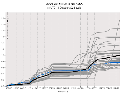
There will be a slow, steady accumulation of precipitation, as shown by the accumulated rain at Seattle (below) through October 22. This plot shows the precipitation accumulating from many model runs, something called an ensemble.
 The map of the total accumulation through 5 AM next Wednesday shows rain over the entire region, with particularly heavy totals (as much as ten inches) over the western side of the terrain in BC. The Olympics and North Cascades get a piece of it.

The official NOAA 8-14 day outlook is for cool and wet over our region (see below).

No complaints will be allowed. We have been drier than normal for the past few months and soils are dry. This rain is good news and will be modest.

Lake Keechelus and Ross Lake are both visibly low. It'll be nice to send some precipitation their way.
ReplyDeleteAre they at normal levels for this time of year?
DeleteRoss Lake is below 25th percentile for this date per USGS.
DeleteAs the headwaters of the Yakima River, Lake Keechelus is monitored in a different way by the Bureau of Reclamation who say that it's at 7% of capacity. I'm not claiming that it either is or isn't in a dire state, but it's rather alarming how much exposed land there is when you drive by. Normal for our current position in the beginning of the water year would probably be something in the neighborhood of 10-20% of capacity. I would venture it's also below 25th percentile if we're comparing it to Ross Lake.
Mt. Stuart was visibly denuded of snow this past weekend, and Slate Peak (7400') in the Pasayten Wilderness was also bare nine days ago. It's time to get the party started.
Yes, I've been looking at the full-disk satellite imagery and the pattern (flow of incoming) looks very typical; here we go! I was surprised by the breezes including a brief spike of warm air, (nearly ten degree rise from 58F to 68F, a distinct cell) during the rains that passed through Glacier yesterday between 12:30 and 1:30 pm. When I was first here, old-timers called events like that "chinooks". I don't know if anything similar happened anywhere else. I've always wondered about the conditions that cause sort of odd, brief event.
ReplyDeleteI will (pleasantly) believe it when I see it! Monday was a nothing burger here in Seattle, just a trace. We need that spigot turned on!
ReplyDeleteYeah, I have noticed that the spigot is usually rusted shut by fall. It usually underperforms the first couple of rain predictions. So far, this seems to be the case.
DeleteFor a few hours today (16th) the BPA chart shows wind (or VER) spiking to >2,500. Then it dropped like a stone from a tower. So, folks running the dams had to stay alert.
ReplyDeleteThe Ellensburg airport (KELN) had a gust of 48 mph at 12:30 pm. Knocked the walnuts out of my trees.
How much did that 20" of rain in November, 2020 push up our November average?
ReplyDelete