The view looking northward over Lake Washington early this evening was dramatic and included towering cumulonimbus towers, some reaching 20-30 thousand feet (see my picture below).
A sure sign of a very unstable atmosphere.
Monet would have loved the scene
An unstable atmosphere has a lot of vertical mixing, with rising air associated with cumulus clouds and sinking air in between them, marked by clear skies. An unstable atmosphere is associated with large decline of temperature with height, with warmer temperatures near the surface and cooler temperatures aloft.
And that is what we had this afternoon. The temperatures of the eastern Pacific are relatively warm, with offshore weather temperatures around 60F. Not Hawaii, but warm for us, following summer and early fall solar heating.
At the same time, a slug of cold air moved in aloft associated with an upper-level trough moving in off the Pacific (see temperature map for around 5000 ft for 11 PM today). The colors show the difference in the temperatures from normal, with light green being the coldest.With a relatively warm surface and cold air aloft, there was a large decrease in temperature with height, which resulted in the lower atmosphere convecting, with upward and downward motion. The upward motions produced clouds, such as cumulus, cumulus congestus, and cumulonimbus, the latter including rain.
You could see the instability clouds this afternoon on the visible satellite imagery (see below, the star is over Seattle). A HUGE field of instability clouds over western WA and the eastern Pacific. Best so far this year.
Radar imagery picked up on the shower activity associated with the instability (see radar image at 5:45 PM below)
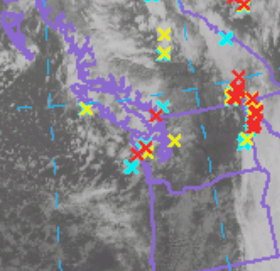
The instability was so great that the resulting thunderstorms produced substantial lightning (see below, x indicates a lighting stroke).
The instability and showers should decline tomorrow.


Saw that today in Kelowna BC. Very dark under the clouds, gusty erratic winds. Looking east I thought I saw mammatus shapes underside. North perhaps Cumulus mediocris
ReplyDeleteWednesday evening I decided to eat an early dinner then head out for my second walk of the day. I left the house about 5:45 PM. That would’ve put me down along Lake Washington’s shoreline just north of Madrona about 6:15 PM. I looked across the lake towards Bellevue and a near-full moon was rising behind a thin veil of clouds. It was really bright behind those clouds. It was dusk at this point; still mostly light out. The skies to the north, toward Lake Forest Park and beyond were dark gray-black. That’s when I saw several streaks of bolt lightning flash across the north sky. They were huge. That’s not quite the ⅓-way point of that walk. I looked around to see if more threatening clouds were closer by. I didn’t see any. I didn’t experience rain, let alone lightning, the rest of the walk. By the time I was walking through Madison Park, it was dark. But it had cleared above the Cascades crest line, the bright, bright moon was lighting the otherwise dark suburban streets.
ReplyDeletehttps://www.flickr.com/photos/bwellsea/54073983661
...
Earlier, while making dinner at my home on East Capitol Hill before my walk I heard a loud boom or rush in the backyard. A huge fall of maple seeds and leaves from the big-leaf maple came crashing down on the back patio. And trees all around the neighborhood were swaying in the brief, strong winds.
That spot on Lake Washington’s shore where I saw the moon and the lightning bolts is an interesting local point. It might be one of the few places where on a clear day, you can see the peaks of Mount Baker (10,786 ft.), Glacier Peak (10,541 ft.), and, of course, Mount Rainier (14,410 ft.)
We were at a Snohomish High School football game. When the game started out, it was actually pleasant and there was some sun shining. However, just to the north of us we saw these large black clouds forming. The UW Weather Radar indicated the storm might skirt by us just to the north. About 5:30 however, the clouds were headed towards Snohomish. The wind picked up and the rain and hail started. The poor kids and cheerleaders on the field were getting soaking wet and it was very cold. Then we saw a couple of lightning flashes very close. The game was called because of the lightning. On the walk to the car, the hail started and it was close to pea sized. This all lasted for maybe 15 minutes or so. What a change in the weather! Glad the game was called! The weather around here sure can change rapidly.
ReplyDelete