May 31, 2025

Potential Aurora Over Washington State on Sunday Evening

 A major opportunity beckons for auroral lovers in Washington State on Sunday evening, with sky conditions being optimal for viewing.


The NOAA Space Weather Center has put out a G4 (Severe) geomagnetic storm watch for late Sunday and Monday (another reason we need NOAA!).  This potential geomagnetic storm is due to a Coronal Mass Ejection (CME) yesterday.  

At this point, the NOAA Space Center is predicting a Kp index of nearly 8 on Sunday evening, which would be a strong event.


My rule of thumb is that I get excited about the potential for an aurora in Washington State when the Kp gets to 7 or more.  We will have that if the NOAA folks are right.

Below is the NOAA schematic for the typical distribution of aurora probability at the Kp 7 level:  we get a piece of the action.

What above viewing conditions?   Clouds or smoke?  The answer is no....viewing should be excellent. 

The cloud forecast for tomorrow evening (a 11 PM) is favorable (little clouds).

The Canadian wildfire smoke is heading south far east of us:

The moon should not be a major problem; it will be about 40% illuminated and lower on the western horizon.  The later you look, the lower the moon.

One issue is the late sunset this time of year (about 9 PM).   Don't bother looking until around 10:30 PM

No guarantees, but there is a decent chance you will see something.  Look north from a place without nearby lights.  My favorite spot is the kite hill in Magnuson Park.  

And remember,  your smartphone camera is far more sensitive than your eye.  You can use it as a tool to see whether anything is there.


May 29, 2025

Hurricane-Forced Winds on Mount Rainier as Strong Winds Descend the Eastern Slopes of the Cascades

 Yes, we had a warm day yesterday, and some welcome light rain has spread over the region last night.

But the real story of the past few days is about wind.  Wind on the mountain crests, wind on the eastern slopes of the Cascades, and the modulation of wind energy over our region.

Consider the maximum winds observed since midnight today (below).   83 mph at Camp Muir around 10,000 ft on the slopes of Mt. Rainier.  88 mph downstream of the south Cascades and 50-70 mph at several locations of the eastern slopes of the North Cascades.


What are the origins of the strong winds?   

Aloft, the strong winds are connected with a strong low (trough) offshore and a high (ridge) inland (see map for 500 hPa pressure, about 18,000 ft at 5 AM this morning below).   This created a big gradient of pressure/heights that produced very strong southwesterly winds.


Lower down, strong winds are aided by a very large difference in pressure (pressure gradient) across the Cascades, with pressure rising rapidly in western Washington as cold, dense, heavy air moved from off the ocean.  The sea-level pressure map for 2 AM today illustrates the pressure pattern (the solid lines are isobars...lines of constant sea level pressure).


The strong westerly (from the west) winds descending into eastern WA are producing a major uptick in wind energy generation (see BPA plot below). The green line is electricity generation by wind, and the red line is the load--the energy demand. Blue indicates hydro generation.


You can see there is a problem with wind generation.  The energy demand went up substantially during our warm period.  Folks use plenty of energy for AC now, since far more homes in the region have air conditioning compared to a few years ago. 

But during the warm periods in western Oregon and Washington, wind energy is nearly non-existent and hydro generation has to spike.

Why is this the case?   

Because heat waves on the west side are inevitably associated with low pressure over western Oregon and Washington (we call it the thermal trough), which prevents westerly winds from descending into the wind turbine area east of the Cascades.  The pressure pattern on Wednesday morning at 2 AM shows the problem. In fact, the winds over the Cascades and along the eastern slopes of the Cascades REVERSE during such situations.


Let me be clear:  this is not to say that wind energy is useless, since can use hydro when wind fails.   

But it is true that wind energy tends to fail around here when energy is needed the most:  during warm spells west of the Cascades and during cold periods during mid-winter (then high pressure settles over the region).

We have a problem during peak energy demand, and this problem is getting worse.

Since solar is problematic around here because of our northern latitude and substantial cloudiness for half the year, and there is little chance for more hydro (in fact, some "environmentalists" want to tear down dams), how will the rapidly increasing energy demand be met?

The obvious place to turn is nuclear---first fission and in a decade or so, fusion.  Clean and reliable.  

Wind and solar can not fill the gap as energy demand rises rapidly, and this is going to be a very serious problem very soon.


May 26, 2025

One Day Flash Heatwave Followed by a Rapid Cooling

 This spring, we have escaped sustained heat and it appears this pattern will continue.  But that does not mean there won't be some transient warm days.  You will enjoy some nice warmth on Wednesday, followed by a substantial incursion of cool, marine air.  And once started, the cooling will be shockingly fast.

Consider the predicted temperatures for Seattle from the UW high-resolution ensemble of many forecasts, with the black line being the average of all of them...probably a very good forecast.

Around 73F on Tuesday and low 80s on Wednesday.


I will admit that I often look at the weather channel predictions since they are the best of the commercial folks.   72F on Tuesday and 83F on Wednesday, followed by a nearly 20F drop on Thursday.    Reasonable.

But what is really interesting is the spatial pattern of the predicted warmth, and for that, nothing is better than the super high-resolution UW WRF model forecasts.  In these forecasts, we solve the atmospheric equations on a grid with points separated by 1.3 km.  This allows us to predict very small-scale weather features.

The temperature forecast for tomorrow (Tuesday) at 5 PM shows a toasty Portland, but only in the low 70s from Seattle to the south Sound. Upper 70s in eastern WA.


But Wednesday afternoon at 2 PM, the western lowlands will be toasty, with temperatures in the 80s.  The Columbia Basin will also warm substantially on Wednesday.


Late Wednesday afternoon a vigorous onshore push of marine air will take place, resulting in a rapid cooling over western Washington.  I love these dramatic marine pushes... I even wrote a paper on it.  The wind chimes will be noisy on Wednesday evening.

The temperatures predicted for 5 PM on Thursday are enough to motivate retrieving some sweaters out of the drawer.  


The cool marine air will deepen and then push over the Cascades into eastern Washington, resulting in wind gusts of 40-50 knots on the eastern slopes (see forecast winds for Thursday morning).  Lots of wind energy will be available!


\


May 24, 2025

Does a Low-Snowpack Mean More Washington Wildfires?

 The headlines in the Seattle Times and elsewhere are ominous:  a low snowpack over Washington State means more wildfires this summer.


Some politicians and state agencies make the same claims.  Less snowpack and earlier melt-out produce a drier environment that brings earlier and greater wildfires.

Sounds reasonable, right?   

There is a problem with this claim: it is not true.   

And there are good reasons why it is not true.

Let's look at the data! 

Last night, I plotted the Washington State wildfire area burned (orange) and the WA April 1 snowpack (based on USDA Snotel sites)--blue line-- for 2002-2024.  The latter was provided by Mark Albright, past Washington State Climatologist.   April 1 snowpack is the classic measure of snow amount before the summer season.

You will notice a few things.  First, there are lots of ups and downs in the snowpack and burned area, but very little correlation between the two.  

There WOULD be a correlation if snowpack were an important modulator of wildfires. 


There is only one year in which there seems to be a connection:  2015.  This was a year with an extremely low snowpack and record-breaking wildfires.  

But correlation is not causation.  It turns out that 2015 had an unbelievably strong and persistent ridge of high pressure that extended from winter into summer.  THAT feature resulted in low snowpack during winter and warm/dry conditions over summer.  Warm/dry conditions that enhanced wildfire risk

Allow me to prove this to you. 

Below is a map of the difference from normal of the 500 hPa heights  (think of pressure at 18,000 ft) for January to April 2015.  The red colors indicate much higher pressure than normal at this elevation.  Such high pressure works powerfully to dry and warm, reducing precipitation and snowfall.
No wonder there was very little snowpack during winter 2015!

But now the essential point.  The ridge stayed very, very strong and shifted a bit to the west during May through July (see below).  This is a VERY, VERY warm, dry pattern for the Northwest and is optimal to promote fires.  

So it wasn't low snowpack that made summer 2015 a tinderbox in our region...it was the atmospheric pattern.

There is no reason to suspect this pattern has anything to do with global warming.  Trust me, I know about this:  I have published papers on exactly this topic.

If one thinks carefully about the issue, one would NOT expect much correlation between Northwest snowpack and wildfires.

Most of our wildfires occur at lower to middle elevations that melt out well before the fire season every year.   Low snowpack years simply melt out a few days or weeks earlier.
So by the mid-summer fire season, the impact is very minimal at the elevation at which the fires are occurring.


Furthermore, a large snowpack can make the wildfire season WORSE by providing moisture longer in the spring, promoting MORE vegetation growth.  

This vegetation rapidly dries out in late spring and summer, providing MORE fuel to burn.

Year after year, the Seattle Times and others have predicted a big wildfire season based on snowpack and were wrong (see below).  Truth and science matter.  

At this point in time, there is no reason to expect an enhanced wildfire season due to snowpack or meteorology.

In fact, the latest USDA Fuelcast predictions of herbaceous fuels over eastern WA are for less than normal (see maps below).


More attention should be given to our mismanagement of our forest lands, human ignition sources (e.g., lack of powerline maintenance), and the intrusion of flammable invasive species around our state (like cheatgrass, aka grassoline).


May 21, 2025

Large Areas of Human-Caused Cooling

 The media is full of stories about human-caused global warming.

But did you know there are large areas of the planet where humans are causing cooling?

Importantly, Washington is a prime example of our ability to massively cool the surface.

We do this by irrigating vast areas of eastern Washington and northern Oregon.

Consider a recent satellite image of our region (below).  
The Columbia Basin should be a desert.  Instead of desert or arid rangeland, we have irrigated vast areas, with the evidence being all the green dots and squares covering much of the basin.


Spraying water for irrigation causes massive cooling by evaporation.  Or evaporation from a wet ground or wet plants results in strong cooling.


When the sun's rays hit the surface, much of that energy goes into evaporating water rather than warming the surface.

You can see the impacts of irrigation on temperatures quite easily. Below are some satellite images (so you can see where the irrigation is taking place) and high temperatures on a recent day (May 9) over a portion of the Columbia Basin (you can see the Columbia River).  Generally, in the 70s over irrigated areas and low-80s over the nearby desert lands.


Here is a blow-up of the next day.  Much cooler over the irrigated area.


The amount of irrigation in the Columbia Basin was rapidly increased in the late 1940s into the 1950s... and it had a profound impact on the temperature trends.  Typically, irrigation results in 2-5 F cooling.  Sometimes more.

At Othello, the mean high temperatures during summer actually DECLINED during the mid-century and stayed down.

Similar lack of warming in Ritzville.


So perhaps you can understand why fewer folks in Eastern Washington are concerned about global warming.😊

If you aren't impressed with the massive temperature experiment in eastern Washington, imagine the profound cooling impacts of the irrigation of large areas of the central valley of CA (see below).


Looking at a station there (Denar 3), you can see a similar lack of warming during the past century.  Cooling due to the effects of irrigation played a role in this.


May 19, 2025

"Drought-Buster" Rain (and Snow) Coming to the Northwest

If you were thinking of putting away your umbrella or rain jacket for the summer season, think again.

Substantial precipitation is coming to the Northwest, including high-elevation snow.  

In this blog, I have sometimes evaluated the scientific validity of the Drought Monitor graphic, which often exaggerates "droughts".    For example, below is the latest graphic, which suggests moderate drought over the western side of the Cascades.


Comparing this to the percent of normal precipitation for the current water year (starting Oct. 1), we see that eastern Washington and most of Oregon have been wetter than normal (green colors), while western WA and the Cascades are 70-90% of normal.


A key point is that Western WA does not need 100% of normal precipitation to be fine.  

We get more more precipitation than we need.  For example, the water levels for the Seattle reservoirs today is ABOVE normal (see below).  The huge Spada Lake reservoir that provides water for Everett is the same.  


So starting in a good position, we are about to be hit with lots of rain during the next few weeks....much more than normal.  Substantial precipitation now is golden---filling reservoirs and streams and moistening the ground before the dry, summer season.  

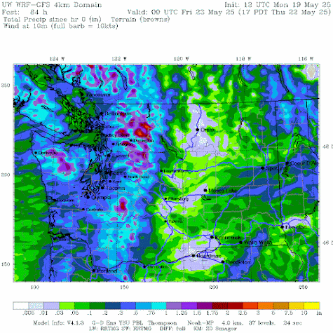
We start with a weak system coming through on Tuesday and Wednesday, which will give the region a good wetting, with about a third of an inch over the lowlands and up to 2 inches in the mountains (the total through Thursday at 5 PM is shown below).   Enough to keep the lawns green.


 But the really impressive action is predicted for next week.  A very large and deep low will develop in the Gulf of Alaska (11 AM on 27 May shown)


Which will drive a plume of moisture into our region (green colors are the moisture plume)


The 5-day precipitation total ending at 11 PM 30 May is shown below.  Up to 3.5 inches of additional precipitation in the mountains.   Enough to quiet any drought talk for a while.

 
And with a cold, low-pressure area offshore, we will even get substantial snow in the mountains (see forecast below).  Enjoy....


May 16, 2025

The Atmosphere is Now in Neutral

Midway through May is a good time to check on the status of El Nino/La Nina,  since its status becomes clearer at this time of the year and will have a major impact on the weather of next winter.

NOAA's latest forecast is out....and I will describe it below.


El Nino and La Nina are on the opposite poles of the same phenomenon:  the shift of the waters of the central tropical Pacific from warmer than normal (El Nino), to near normal (Neutral of La Nada), to below normal (La Nina).

A plot of the sea surface temperatures in this critical area (the Niño3.4 area) is shown below (actually the differences from normal).  After experiencing the cool waters this winter (La Nina), we are now in neutral territory.


The correlation of the tropical water temperature with our weather during the summer is weak in any case, but winter is a different story.   

So what do the latest forecasts suggest? As shown below, although there is quite a range in predictions, the general trend is towards continued neutral conditions for the remainder of the year.

What are the implications of neutral conditions for next winter?

Increased chances of a major wind event from an approaching midlatitude low-pressure system.

Increased chance of a strong atmospheric river that produces major flooding.

Bottom line: neutral years are known for their meteorological action.  


May 14, 2025

More Serious Rain Returns

 It has been cool, and there has been some light rain over western Washington.   Several of you have emailed me, asking when we will get more serious moisture.

Your answer is below.

Let me show you the latest European Center precipitation forecast for our region.  From 11 AM today through 5 AM Friday, there is light rain over the region, with moderate rain over the mountains.

With winds from the west, the eastern slopes of the Cascades will be rain-shadowed.

Then the rain picks up as a trough of low pressure moves through over the weekend, with the totals through Sunday morning exceeding 1 inch over the western slopes of the mountains.  Saturday might not be a good hiking day.

 The totals steadily increase through Tuesday morning.

You will notice that the precipitation will be relatively light over the lowlands of western Washington. Why?

This is because the winds often blow from the west this time of the year, which tends to produce downslope flow and drier conditions downstream (east) of our generally north-south terrain barriers.

This is illustrated by the winds around 5000 ft on Friday morning below.


During the winter, winds are more southerly, allowing more precipitation in the lowlands.

This type of pattern also produces large temperature contrasts across Washington State.

Consider the situation on Saturday at 5 PM.  Temperatures are in the low 50s in western Washington, but around 70°F in the Tri-Cities.  So head across the Cascades if you want some springtime warmth.