At 10 AM, some locations around Puget Sound were reporting mixed rain and snow, and some higher elevations (like Paine Field in Everett) were all snow. However, the temperatures aloft are relatively warm and the road surfaces have warmed after our relatively balmy weather. So not much is sticking. But you can see flakes on some web cams (see one near Paine Field below), with some whitening on grass.

The issue: warm temperatures above. A plot of temperature with height at 9:30 AM shows a freezing level of 1750 ft, which implies a snow level of 750 ft. Yes....the higher hills could get some accumulation, but not much near sea level.

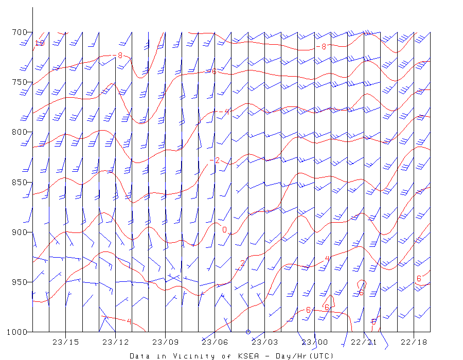
A plot of temperatures aloft (over Seattle) in time, shows -2C air at 850 hPa (around 5000 ft). That is extremely marginal for snow, particularly when one does not have cold air in place at low levels.
The forecast pressure pattern is also not favorable, with a low center right over us and no feed of cold air from the Fraser River Valley (see forecasts of pressure and temperatures for 10 AM below).


Sorry for folks wanted a white Christmas at sea level. But there is plenty of snow in the mountains.
.gif)


Light snow turned to mixed flurries for an hour, then rain/snow mix.
ReplyDelete10:43 AM 12/23/16 Bothell, WA 103rd PL NE
Light snow turned to mixed flurries for an hour, then rain/snow mix.
ReplyDelete10:43 AM 12/23/16 Bothell, WA 103rd PL NE
I don't know. It's been dumping in Bellingham all morning. 2 inches so far and doesn't look like it's going to stop.
ReplyDeleteTotally different story up here in Whatcom county - it has been snowing heavily and steadily since around 7 am with no letup. 2-3" accumulation through most of Bellingham and likely higher amounts away from the water. This is more snow in a single event than we received during last week's storms.
ReplyDeleteAs recently as last night the prediction was for potentially a little snow, late in the day, and only at elevation - given how far that was off the mark, not sure what to expect in terms of further accumulation or how long it will last.
I'm in North Whidbey at 250 ft above sea level and have just under an inch of really wet snow.
ReplyDeleteIn Arlington Heights at 200 ft elevation, about 4 miles east of Arlington, WA, it has been snowing solidly for about 2 hours now - close to 1 in. so far.
ReplyDeleteI'm in the Eastgate/Factoria area and it's been snowing steadily since about 11:45. It's not sticking yet but I live in hope (with expectations of it not sticking).
ReplyDeleteIt hasn't been sticking yet (i live in hope) but it's been steadily snowing here in the Eastgate/Factoria area since 11:30 am and is still coming down.
ReplyDeleteIn Woodinville at 400 ft its been snowing since around noon. The soft surfaces are covered with about 1 inch and it is just starting to stock to the roads and driveways.
ReplyDeleteIn Whatcom County it snowed much of the day, contrary to forecasts. Treacherous conditions in the morning led to a host of accidents. Flights out of Bellingham have been delayed at best & in a few cases, cancelled altogether. Not minor for a number of drivers, or for those of us who have air travel plans this weekend.
ReplyDeleteWe Bellinghamsters are all excited. With 2-3 inches on the ground and the light rain ending we have a good shot at a White Christmas - not like the ones I used to know (upstate NY), but good enough for around here!
ReplyDelete16 day GFS is showing a very ominous trend after Jan 1. Modified arctic air meeting up with some moisture. Will be interesting to watch.
ReplyDelete