November 30, 2019

Sunday Snow Update

Something called precipitation is approaching Washington State right now--- a quantity relatively unfamiliar this month in our region (see radar at 9 PM Saturday).  Not particularly impressive amounts.  Eugene, Oregon started as a snow/rain mixture and turned rapidly to rain.


This band will move northward during the next 12-18 hrs, bringing precipitation to our region.

The "problem" for snow lovers is that the air above us has warmed considerably today, with a freezing level above Sea-Tac of 2636 ft.  Since it takes about 1000 ft of above-freezing air to melt snow, you can appreciate the issue.  And the air above us will warm as the precipitation, associated with  a warm front, approaches.

Plot from Seattle SnowWatch

The latest UW WRF run, straight off the computer, is shown below.  The plot provides the 24-h snowfall ending 4 PM Sunday.  Not very encouraging for those looking to create a snowman in Puget Sound country.   Seattle's Mayor Durkan can sleep well tonight.

The mountains will get some light snow, as will the eastern slopes of the Cascades.  The hills of SW WA might get whitened, and Portland, cooled by outflow from the Columbia Gorge, could see snow or freezing rain.  Other modeling systems, like the NOAA/NWS HRRR model has a similar solution (see below).

My apologies to snow lovers of the area and to snowplow drivers looking for some overtime pay. 

November 29, 2019

The Sunday Snow Forecast for Western Washington

The Seattle Times has a headline about possible snow in the lowlands on Sunday, and I have gotten a number of emails about it.....so let's examine Sunday's situation.   The bottom line: there is little to worry about.

This morning dawned clear and cold, in fact, one of the coldest mornings so far this fall.  Temperatures ranged from mid to upper 30sF near the Sound to low 20s away from the water.  But travel east of the Cascade crest, and lots of locations dropped into the lower teens, even single digits in low/cold spots.  This cold  is allowing Mission Ridge and Crystal Mountain to make snow and open.


Some frost around the region, but little fog.  Why?  The air is simply too dry.

There will be no precipitation today and Saturday.  But Sunday, a low pressure system will be approaching from the southwest, spreading clouds and precipitation into the region.

To illustrate,  here is the predicted surface chart for 1 PM Sunday, including sea level pressure (solid, lines), surface winds, and low-level temperatures (color shading).  You can clearly see the low pressure center offshore and it you look closely, you can see southerly winds and warmer air pushing northward to its east.  In fact, there is a weak warm front pushing northward along the WA coast.  Easterly winds are over western WA and temperatures are cool, not cold (green colors).


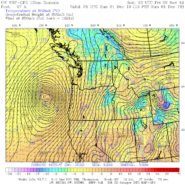
Moving to a level around 5000 ft (850 hPa),  southerly winds and warmer temperatures (yellow/orange colors) over western WA are apparent.  Not good for snow.


The latest  UW WRF high-resolution snow total prediction through 10 PM Sunday, shows no snow near Puget Sound and some light snow at higher elevations.  Just too warm.


Now, if it possible a few flakes could be observed when the precipitation starts in the Seattle area on Sunday morning, thanks to intense cooling from evaporation as the flakes fall into dry air below, but this will quickly turn to all rain.  There could be a dusting just to the southeast of the Olympics and over the higher terrain of southwest WA.  If you are driving on  I5 over SW WA during the initial light snow period, slow down and making sure you have adequate following distance...we don't need another Spokane accident scene.

If you want more information, do what I do and go to Seattle SnowWatch, a website that has the best collection of snow/temperature data for the region that exists.  This is a joint UW/City of Seattle project.

Finally, notice how dry this November has been.  As described in my next blog, this has been the driest November since 1976!


November 27, 2019

The Spokane MegaCar Crash Up, Snow, and a Warning for Southwest Washington

Yesterday around 2 PM, a band of light snow passed over I-90 just southwest of Spokane.  The result was bedlam, with over ONE HUNDRED cars being involved in dozens of multi-car accidents (see picture).

Fortunately, no one was seriously hurt.   The cause of this disaster?  The meteorological issue was a narrow band of snow showers that dropped .5-1 inch of snow over the highway in the space of 30 minutes (see satellite picture).  I put a blue oval around the cloud band for your reference.


The onset of snow was very rapid.  Compare the WSDOT I-90 cam shot at Geiger Blvd at 1:50 PM Tuesday, with 2:07 PM.  Quite dramatic.


Surface air temperatures were in the mid-20s,  but the road temperature was above freezing.  That produces a very slippery, melting layer on the road.

Now, it is pretty evident that folks were surprised by the snow squall and one can suspect that they did not slow down adequately and increase following distance.  The result was a scene of bumper cars.

Now I mention this now because a similar situation could occur Sunday morning over NW Oregon and SW Washington.  We will have cold temperatures in place.  A weak system will be approaching from the southwest.  The latest model runs suggest the potential for light snow extended northward, as far as roughly Tacoma.

To illustrate, take a look at the European Center cumulative snow forecast from the latest run.  Through 4 AM Sunday-- no issues in the west.
 But by 10 AM Sunday, up to around a half-inch.  There is a LOT of uncertainty with this forecast.

So if you are out driving on Sunday morning, be careful.  We don't need a second mega-car pile up at the end of the Thanksgiving weekend.

Finally, the big storm yesterday produced gusts up to 95 mph in exposed locations (see map showing max gusts).  A very good forecast starting 84-h before landfall.


November 26, 2019

The Oregon Storm is Exploding

The meteorological-bomb storm is not disappointing-- in fact, it will probably be stronger than originally expected.

The visible satellite picture around 10:30 AM shows a beautiful storm developing, with the low center in the center of the swirl of clouds due west of the central Oregon Coast.


One way we can tell this storm is deepening rapidly is looking at the water vapor imagery, which shows the amount of water vapor in the upper troposphere.  Blue indicates lots of moisture, red/orange very little.  There is extreme dryness behind the storm that is the result of vigorous descent behind the low.  Such strong descent only occurs in rapidly deepening, intense storms.


The latest run of the European Center model predicts that the storm will bottom out at an impressive 969 hPa (or millibars) just offshore of the Oregon/CA border.

The latest, high-resolution run of the UW WRF model predicts gusts hitting 80 knots offshore around 4 PM (see below).  That's 92 mph.  The European Center is going to 100 mph.  Wow.


Around 11 AM, winds were already gusting to 50 mph along the coast from northern CA to southern Oregon.  This is just the beginning.

And at buoy 46027, just offshore of far northern CA, the pressure is plummeting (green line) as winds gust to over 45 knots (red line).


All hell is about to break loose along the southern Oregon/northern CA coast, as one of the strongest storms in years savages the region.  If you live there, taking shelter in locations not vulnerable to falling trees would be a very good idea.

_____________________________
Announcement:  I will be teaching Atmospheric Sciences 101 during winter quarter

If anyone is interested, either a UW student or outside folks using the ACCESS program, I will be teaching this general introduction to weather in Kane Hall (210) at 12:30 PM.


November 25, 2019

A Bomb Cyclone Will Hit the Southern Oregon Coast

An explosively developing bomb-cyclone will hit the southern Oregon coast tomorrow, with hurricane-force wind gusts, towering waves, and lots of precipitation.

The term "meteorological bomb" is given to a midlatitude cyclone whose central pressure declines by more than 24 millibars (or 24 hPa) in 24 hours (there is a latitude dependence of the criterion, but this is close enough).  This storm is going to blow that criterion away.

Virtually all the models agree on this extraordinary strengthening, so confidence it quite high.  And there are some aspects of this storm that are very unusual. Let me show you the details.

The initial step in the development of the storm, a process called cyclogenesis, is occurring as I write this blog. The latest forecast for 4 PM today (below) shows an extremely weak initial development on a preexisting warm front, with the low pressure center being a very modest 1022 hPa (I put a blue oval around the developing storm in the weather map below, which shows pressure (solid lines), temperature (shading) and surface winds).


Fast forwarding to 3 AM, the low center pressure had deepened to 1009 hPa (13 hPa in 11 hours).


But now the storm is ready to explode.  By 10 AM Tuesday, the storm's central pressure had plummeted to 983 hPa (39 hPa in 18 hour!).   Well exceeding the requirements to become a bomb cyclone.


And as the storm makes landfall around 6 PM Tuesday, the storm is predicted to be around 980 hPa.  In fact, I am only showing you the medium resolution simulation (12-km grid spacing).  The higher resolution domains drop the pressure to around 978 hPa at landfall.   


Notice the HUGE pressure gradients (pressure differences) associated with the storm.  These will produce tremendous winds in the coastal zone and immediately offshore.  You see the blue colors?  That is cold air that will be streaming from the northwest at the same time, sucked to the southwest by the low pressure center.  In fact, the high pressure associated with the cold air is contributing to the strong pressure gradients and strong winds.

Talking about the winds, here is the wind gust forecast for 5 PM tomorrow (Tuesday).  Gusts to 70 knots (81 mph) to the west/southwest low center.  In the field, this is known as the "poisonous tale of the bent-back occlusion."   Repeat that to your friends...they will be impressed.


The strong winds will rev up substantial wave activity, reaching 11 meters (36 feet) along the coast.  Particularly impressive, considering short-duration of the winds from this fast moving storm.

And there is more, much more.  The storm will bring substantial precipitation from southern Oregon into northern California (see below), reaching 2-5 inches in the Sierra Nevada.  Not much in Washington.

And with cold air streaming in from the northeast, large amounts of snow will fall in the Oregon Cascades, the Siskiyou Mountains, and the Sierra Nevada.  In some places, several feet (see forecast of the total snowfall through noon Wednesday).  If you are planning on driving south from Oregon into California or across the Sierra Nevada, bring your chains.

The National Weather Service forecast summary for the region has almost every  type of warning imaginable, from high wind warnings, storm warnings, and winter weather warnings, to high surface warnings and more.

An unusual aspect of this storm is its track--from the west/northwest.  Most major cyclones this time of the years comes from the southwest.

Anyway, a major event--but what should we call it?  A day later, it could be the Thanksgiving Eve storm.  Will have to think about it....


November 23, 2019

The Remarkable Steve Pool

There are some people in this world that really have a major impact on improving the lives of others, and few have done more than Steve Pool, who will retire this week as Chief Meteorologist at Seattle's KOMO TV.  As we shall see, his efforts at KOMO TV for over 40 years are only a small portion of his contributions to my discipline, dozens of students, the community, and the University of Washington.

Steve and I go way back.  It all started the mid-80s, when I got a call from KOMO-TV asking whether I might be willing to train Steve in meteorology, since he had just taken on weather responsibilities at KOMO-TV.   For the next year and a half, Steve and I worked together intensively to cover the essentials of meteorology, Northwest weather, and weather forecasting. An extraordinarily bright guy, Steve was a meteorological sponge, quickly mastering a huge volume of information that was equivalent to a good part of the undergraduate curriculum--and he also became decent forecaster as well. 

But while I might have had an advantage on the meteorology side, it was clear to be that he was a preternaturally talented communicator and in that domain I had a lot to learn from him.  I mean smooth.  An ability to connect with people.  A disarming smile, great empathy, and a personality that was so upbeat and sunny that it was like opening the window on a sunny, spring day.


We would regularly talk about difficult forecasting situations, driven by his strong commitment to not only get the forecast right, but to get the explanation correct.

As Steve mastered the meteorological world and became one of the most accomplished TV meteorologists in the nation, he called one day, suggesting the idea of UW students being interns at KOMO.  This internship turned out to be a huge success, giving roughly 3-4 students a year an extraordinary chance to assist in developing the daily weather offering on KOMO, including use of a complex graphics system, preparing forecasts, and even practicing in front of the camera.  All under the eyes and with assistance of a master weathercaster.   Many of Steve's student interns went on to successful careers as TV meteorologists, including Shannon O'Donnel, M. J. McDermott, Kelley Bayern, Nathan Santo Domingo, Jefferson Davison, Brandon Wholey and Matt Leach--to name just a few.  And now Shannon O'Donnel is going to teach a regular course in media communication, to complete the circle.  Steve's influence will be very, very long lived.

But there is more.  Steve encouraged KOMO to secure a weather producer (Erik Toth) to heighten their game even more, and Erik was later replaced by the extraordinary Scott Sistek, who has been at KOMO for over 20 years.  Importantly, Scott, with Steve's encouragement, moved into social media, and now Scott's weather blog is one of the region's finest (no, Scott and I are not in competition).  Steve and Scott even wrote an excellent, conversational book on Northwest weather that received an impressive 5-star rating.


Steve was extremely interested in outreach to young people, and a good example of his efforts was the annual Weather Education Day at Safeco Field. Before the game, THOUSANDS of students would enjoy learning about basic weather principles and local weather, presented by Steve and his guests (I even did it one time).


Steve became a mega-local celebrity, but this did not change him, and he used that celebrity to assist in fun raisers and other gatherings for local charitable organizations and importantly for his alma mater, the University of Washington. He helped raise millions of dollars for a whole slew of important causes.  And on the side, Steve built a small enterprise, assisting folks in learning how to be accomplished communicators.

As many of you know, Steve had a health set-back during the past few years, having to deal with prostrate cancer.  But after treatment, be appears to have beaten it, and ready for a new stage for his life.  The TV weather business has greatly changed over the past decades, making it a frenetic activity of many weather segments throughout the late afternoon and evening, with attendant demands to update social media.  In the old days, there was a 6 PM and 11 PM weather broadcasts, perhaps with one at 6:30 PM or 10 PM.   Now it's a race, and not as much as fun as before.

Whatever Steve does, I wish him the best in this new chapter of his life.


November 21, 2019

The Northwest Will Go Cold Turkey, But What About Snow?

It is now becoming clear that a major cold period will occur next week, cold enough that if you lack enough refrigeration foryou holiday meal, you can simply put the food  outside.


Highs will only rise to the upper 30sF on the western side of Cascades and there will be substantial snow in the mountains.  But will there be lowland snow?  That I will explore later.

The models are now consistent in bringing cold air southward, as illustrated by the WRF model forecasts shown below, which present sea level pressure (solid lines) and temperature about 3000 ft above the surface (color shading).    Next Tuesday at 1 PM, cold air (blue colors) is entering the region, pushed southward by high pressure in Canada and a low pressure area off the northern Oregon coast).


By 10 AM on Wednesday, cold air is entrenched over the Northwest, with a very strong north-south pressure gradient that will create strong northerly and northeasterly winds. 

The cold is "in the bag", based on lnsemble predictions in which the models are run many times.  The forecast temperatures at Sea Tac, based on the European model, indicates highs in he low 50s this weekend (pretty typical), but then the "cold turkey" comes in Wednesday and Thursday.


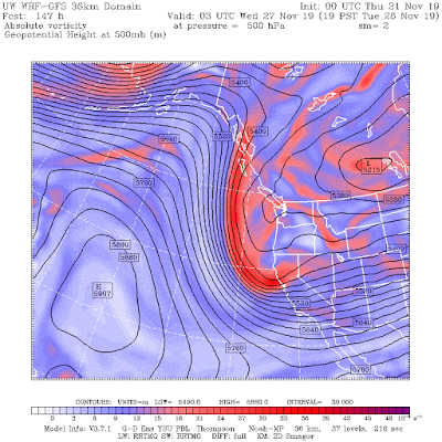
The cold wave will be initiated by the movement southward of an upper trough (see below for 7 PM Tuesday), but it is too broad and offshore to provide western WA with lowland show--perhaps a few flurries.   There is a bigger risk for Portland


The WRF snow accumulation forecast though 4 AM Thursday shows snow on the slopes of the Cascades, but very little over the Puget Sound lowlands....Portland has a better chance.


I know some of you love lowland snow (or fear it), but November is early for the lowlands.  We need colder air, with an upper level shortwave and its surface reflection that would result in easterly flow over the Cascades, which tends to cause drying over the lowlands.     But the situation is still well out in time and things can change.  Stay tuned.

November 19, 2019

Satellite Extravaganza

The MODIS weather satellite image around noon on Monday had something for everyone, including a major Pacific cyclone and attendant fronts approaching our region (see below).


We start with the swirl of clouds into a low pressure center west of the Washington coast, with the lowest pressure in the center of swirl.


Then there is the shadow of the highest frontal clouds on the extensive middle level cloud deck to the west.

And there is rope cloud, a very narrow, but intense cloud band that shows the exact position of the cold front associated with the storm. 


And, don't forget the ship tracks, lines in stratus or stratocumulus clouds produced by the combustion products ejected into the marine atmosphere from marine vessels.  The ship effluent increases the number of cloud droplets, which appear more white in the satellite image.


And as an EXTRA BONUS, let me show you an image around 3 PM from the new GOES-17 satellite.  This system developed TWO low pressure/circulation centers!  Which is actually not good if you want an intense storm.


Can you imagine being a meteorologist before there were weather satellites?

November 17, 2019

Is Seattle Really the Gloomiest City in the U.S.?


The media is often full of negative and depressing news, and this week the Seattle Times did not disappoint, with an article suggesting that Seattle is the gloomiest city in the U.S.  And their cartoonist, David Horsey, followed up with more of the same.


But inquisitive Seattle residents might ask:  is this really true?  Is Seattle truly in the basement of gloom?

Perhaps not...so let's explore this issue, from both psychological and meteorological viewpoints.  Now, first--what is gloom?  As shown by the definition below, it can either refer to darkness, or more importantly, a state of melancholy or low spirits.


There is, in fact, a scientific literature on the distribution of gloom around the nation.  What does it say?

One example (here), providing a map of mental distress across the nation, suggests that Seattle is far from the worst, with parts of California and the torrid southeast U.S. being far sadder.  The paper talks describes the "gloom belt", and folks, we are not in it.


But being in high-tech Seattle, let's check the results of mining the twitter archive to judge regional mood (another peer-reviewed article), with higher numbers indicating more happy tweets.  Washington is one of the happier states! (Yes, Hawaii is the most happy, with Maine and Nevada right behind).


So clearly, there was something wrong with the gloom index used by the Seattle Times, which is only based on percent of cloud cover, hours of daylight, and days with precipitation (and put together by a website called Best Places).

Now there is a lot the gloomers at Best Places/Seattle Times missed.  For example, did you know that too MUCH sun is depressing?   It is called Summer Affective Disorder (SAD) or Summer Depressive Disorder.   Oppressive, ever-present sun.  High humidity.  Glare.  Sweat.  Biting insects.  In many places (SW U.S., India, SE U.S.), summer depression is a real problem.


Looking the summer heat index, which combines temperature and humidity, the SE and SW U.S. are just miserable during the summer. And it is well known that crime and disorder increase during very warm weather.

But we generally escape this affliction in the Northwest, with the most pleasant summers in the nation, particularly west of the Cascade crest.   So it makes sense that from late spring through early fall, Seattle residents are happier than many others around the nation.

The gloom analysts at Best Places and the Seattle Times also miss out that many people like rain.  In fact, there is a literature describing how rain can make people happier.  One theory is that rain is a source of white noise that is pleasant for the brain.  That is certainly true for me.  It is also an excuse to find a warm, cozy spot, to reflect, enjoy tea or coffee, or to read.  You don't feel guilty for not running around outside.  Life is good.

Other studies suggest after living in a place in constant sunshine, the brain adapts and takes no notice.  In contrast, here in the Northwest, when winter clouds part to give us a good shot of sun, our brains are flooded with neurotransmitters, providing a psychological high.

To give a pharmacological analogy.  If one takes pain killers for an extended period in time, they lose their effects.  In contrast, if you take one rarely, they give you quite a jolt when you take one.  The difference between living in San Diego or Seattle.

But there is more.   During Seattle winter, many of the trees and ferns are still green and vibrant, and our grass stays green, in stark contrast, to the brown, lifeless (depressing) vegetation over much of the U.S. (the picture below was taken on January 7th by Peter Stevens).


And on many a winter day, it is easily possible to get some sun with a short drive, into the mountains, past the Cascade crest, or to sunny Sequim.   Many Seattle residents know this.

I hope the Seattle Chamber of Commerce has a little "talk" with the gloommeisters at the Seattle Times.  Perhaps Jeff Bezos knew what he was doing when he build Amazon here in Seattle, as did so many other leading firms.  And yes, there is a movie I can recommend:

_____________________________
Announcement:  I will be teaching Atmospheric Sciences 101 during winter quarter

If anyone is interested, either a UW student or outside folks using the ACCESS program, I will be teaching this general introduction to weather in Kane Hall (210) at 12:30 PM.

The Autumn Transition

Nearly every September has a transition to fall-like weather, with no going back.  We are in such a transition right now.    For Washington ...