December 30, 2022

My new podcast: the warmest and coolest places during the winter in the Northwest

 Several folks have asked me about the winter extremes of the region, so I decided to do a podcast about it (see below).

As shown in a map of the average January minimum temperatures below (from my book), the coolest temperatures are found east of the Cascade crest, where marine influence is limited by that mountain barrier.   Warmest temperatures are along the coast, where the relatively warm Pacific Ocean keeps things moderate.

Look closely and you will see the warmest temperatures are on the southern Oregon coast from Brookings to Coos Bay.  The Banana Belt of the Northwest.  As explained in the podcast, the high terrain around Medford plays a large role in this warmth.

And then I take on the issue of the coldest locations of our region, with the Washington records in the high Methow river valley, where cold air sinks down into the towns of Winthrop and Mazama.  And there is more....

Winthrop and Mazama are found in the relatively deep Methow River Valley

To listen to my podcast, use the link below or access it through your favorite podcast service.


Some major podcast servers:

 HTML tutorial HTML tutorial
Like the podcast? Support on Patreon 


December 29, 2022

The Origin of Seattle and Tacoma Flooding This Week

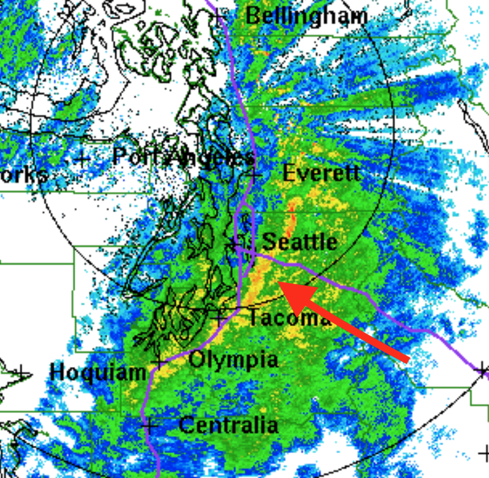
 There has been a lot of discussion in the media and elsewhere about the recent flooding in Seattle's South Park neighborhood, and others have noted high water levels on the Sound shoreline, including Alki Beach and Tacoma (see some pictures below).

The origin of the flooding is described in this blog.  

To give away the punchline, the flooding was the result of an unusual astronomical setup producing King Tides, extreme low pressure from a powerful storm, moderate rainfall, and a human-caused vulnerability in South Park that should have been dealt with years ago.

Although some are making unfounded claims about climate change, global warming played very little role in the flooding event, something I will prove to you below.

The South Park flooding, courtesy of the SDOT Blog

Coastal flooding in Tacoma.  Picture courtesy of Jenni Wynkoop

King Tides

The key aspect of this event was the King Tide, very high high-tide levels resulting from an unusual astronomical alignment of the Earth, Moon, and Sun.

As many of you know, tides are the result of the gravitational attraction of the moon and sun on the oceans and large bodies of water.     When the moon is closer to the Earth (in perigee) tides are large.  When the sun and moon are aligned (as in full or new moon) the tides are higher.  And when the Earth is closest to the sun (which occurs in early winter!!) tides are higher.


This week all of these factors were near optimal, producing a high-amplitude King Tide, with NOAA predicting King Tides reaching 12.9 ft above sea level on December 26 and 27.

Below are the predicted (blue) and observed (red) water levels for December 25-27 in Seattle from NOAA.  The forecasts were excellent on December 25th but greatl underpredicted the actual maximum water level (about 15 ft!) on Tuesday, December 27.    

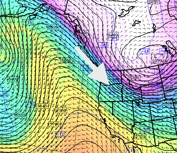
But why such a large error?  Global warming did not suddenly show up for a few days.   It has to do with the low pressure associated with the incoming storm on Tuesday.
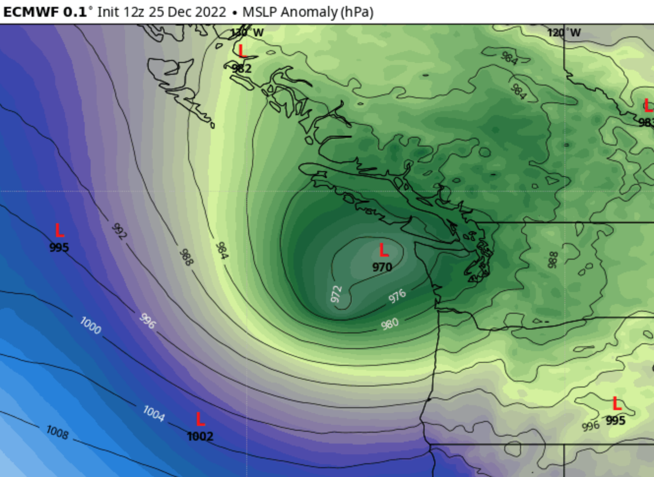

Low Pressure Produces High Water Levels

It turns out that a regional low-pressure center caused localized water level increases, something called the inverse barometer effect (see figure).

Image Courtesy of Swellnet

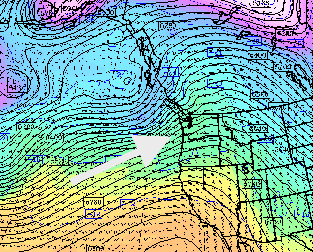
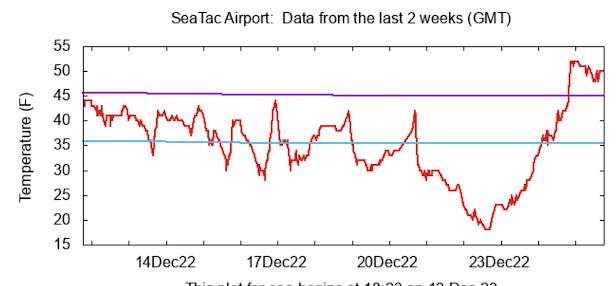
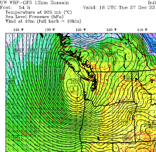
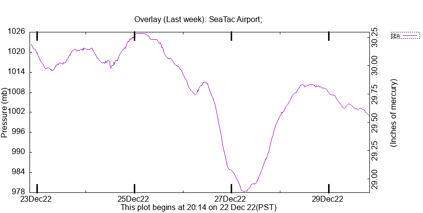
The sea level pressure above western Washington was EXTRAORDINARILY low on Tuesday--the lowest of 2022.  Want proof?  Here are the pressures at SeaTac Airport for the period.


Here is a close-up view of the pressure this week at SeaTac.  Mama mia!  Down to 978 hPa/mb on the 27th.  Folks this is very low pressure for the interior of western Washington.  Water levels would be much higher as a result.

,

So we start with an unusual astronomical setup, with high tides we only see a few times a year.  And then we get extreme low pressure that happens to occur on the King Tide day.

But what about the rainfall?

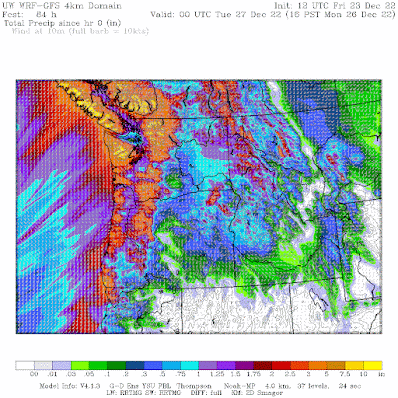
The major low-pressure system/cyclone making landfall on Tuesday brought moderately heavy rain to the region,  with 2-3 inches falling on the western slopes of the Cascades over December 26-27.  1-2 inches fell over the lowlands during the same period.   Heavy but not exceptional.


This moderate rainfall drained into the Green/Duwamish River, which started out considerably BELOW NORMAL (see the Green's river level at Auburn below).  The substantial rainfall resulted in water levels rising to normal levels on December 27th and about 2 feet above normal on December 27th. (note that hollow diamond symbols indicate normal levels)


So we had an unusual astronomical configuration, a storm with unusually low pressure, and moderate rain associated with the storm.  The astronomical and pressure effects resulted in a high tide about 3 feet above normal in the Sound.

Sea Level Rise

How much might sea level rise, which is only partly due to a warming Earth, contribute to the high water?  

Below is a plot of sea level in Seattle over the past 120 years.   You will notice that sea level has gone up about 2.07 mm per year.  That is 4 inches during the past 50 years.    That certainly does not explain what happened earlier this week.   A very small contribution.

An interesting point is that sea level rise is not accelerating during the past decades, something one would expect if global warming was the dominant cause.  Also sea level rise has been going up for a long time...before mankind could have been the cause.  In short, the contribution of global warming to regional sea level rise is highly uncertain and certainly small at this point in time (it will increase later in the century).

The Human Cause of the South Park Flooding

The South Park area has flooded repeatedly during the past century, which is not surprising:  it is located on the historical flood plain of the Duwamish/Green River.  The "river" next to South Park is a totally artificial human-constructed channel.

But the big problem is that during high tide the stormwater drainage pipe for the area CAN NOT DRAIN INTO THE RIVER.   So appreciable rain brings flooding.

This is an essential flaw in the drainage engineering of the region and the City has known this for decades.   Here is a quote from a City of Seattle website:

Today they are constructing a pump station to reduce the problem.


Disappointingly, the story in the Seattle Times on the flooding did not discuss the above engineering flaw at all.  The initial version of the story missed the low-pressure contribution as well.  And the SPU statement on the flooding tried to suggest that it was associated with climate change.

Poorly informing or misinforming the citizens of the city about environmental challenges is counterproductive to solving problems.   Or in bringing "environmental justice" to residents of South Park.

December 27, 2022

A Potent Storm with A "Poisonous Tail" Makes Landfall Today

A powerful Pacific cyclone is now approaching landfall and its powerful winds have already caused massive power outages over Oregon, where over 100,000 customers are in the dark as I write this.

Washington State is next.

Infrared satellite imagery shows the large-scale cyclone over the West Coast (see below).  Huge in scale.

A close-up visible image this morning shows the circulation with the low west of Westport.


Now the exciting part: the coastal radar on Langley Hill near Hoquiam is picking up the circulation offshore (see below).   Very helpful.  I always think appreciably of Senator Maria Cantwell when I see such images (she played a critical role in securing the hardware).


The Poisonous Tail

Oceanic midlatitude cyclones have a structure different than cyclones over land, and the current storm is no exception.

Below is the analysis of sea level pressure (solid lines) and wind gusts (color shading) at 4 AM this morning.   You will notice a large pressure change and strong winds on the Oregon Coast, which led to lots of power outages.  

But do you see the strongest winds and large pressure gradients to the south and west of the low center?  That is known as the "poisonous tail".  And that tail will reach western Washington later this afternoon.


The maximum winds from midnight to 9 AM today so far are shown below.  Exposed locations in the coastal mountains of western Oregon experienced 80-90 mph gusts, while 60-70 mph gusts raked the coast.   Southwest Washington had 50-60 mph gusts.  Strong winds also hit eastern Oregon.


The Forecast

This is not an easy forecast.  The winds at any particular location will be critically dependent on the exact path of the low

The UW model forecast has the low weakening a bit and moving across the northern Olympic Mountains by 1 PM, with a huge pressure gradient (and strong winds) over NW Oregon.  Not good for Portland.


By 10 PM tonight the low is in southern BC and a large pressure gradient is over western Washington.  The early evening will be the time of strongest winds over western WA.  Southerly winds over Puget Sound and powerful westerly winds in Strait.  Expect winds to accelerate in western Washington around 4 PM.


The NOAA/NWS HRRR model has a similar solution, and let me show you its latest forecast (started at 9 AM) for the strongest winds through 7 PM.

Strong winds (50 mph+) along the coast and Strait.  Central and northern Whidbey will be hit hard.  50 mph+ gusts from downtown Seattle to Olympia.  Crazy strong winds on exposed higher terrain of the central/southern Cascades.

The European Center model is taking the low on a more southerly path, which would be less threatening.

This storm is typical of one of the stronger cyclones we get each year, but not like one of the majors (Columbus Day, Inauguration Day, Chanukah Eve).  Its track is not optimal, it is weakening on landfall, and other reasons.

If you are living in western Washington, you would be wise to charge your electronics now and prepare for a power outage.  Stay inside during the strongest winds later this afternoon and evening.

December 26, 2022

The Upcoming Windstorm (Plus Another One This Morning)

 There is a lot of wind to talk about in this blog--a significant Pacific cyclone will make landfall on the Northwest coast tomorrow....and strong winds will result.

But before I get into that, there was a blow this morning in western Washington as a powerful cold front went through from roughly 7-8 AM.  Below is the Camano Island radar image at roughly 7:15 AM below, with the arc-shaped frontal feature in yellow to red.


This feature is an intense narrow cold frontal rain band, and was associated with winds gusting to around 50 mph, a rapid wind shift, and a significant temperature drop.  The models had it, but underplayed its strength.    

The maximum winds this morning are shown below. 55 mph at SeaTac, 59 mph in Bellingham, and over 60 mph on the coast.  No wonder there are about 100,000 customers out of power in the region.


The Storm

But this is just a "warm up" for the event of tomorrow afternoon and evening.

Offshore, satellite imagery shows a massive cloud feature over the northeastern Pacific, something characteristic of the stronger storms.


The latest UW model forecast of sea level pressure (solid lines) at 10 PM tonight shows an impressive 970 hPa low center off the southern Washington coast, with a very strong pressure gradient (change of pressure over distance) to the south and west of the low.

This is a classic structure for marine midlatitude cyclones.   At that time there will be a strong north-south pressure difference and strong winds from southern Oregon to the Bay area.


Twelve hours later (10 AM Tuesday) the low makes landfall on southern Vancouver Island and a hyper pressure gradient builds over the Oregon coast.  Expect winds gusting to 60-80 mph and power outages along the coast and in the Willamette Valley at this time.


But the interior of western Washington will get its turn.  By 4 PM tomorrow, the low will move into southern BC and an intense pressure gradient will develop over the western Washington lowlands, producing powerful southerly winds gusting to 50-65 mph.  More power outages are probable, particularly with saturated soils.


But the strong wind fun is not over.  As the low moves inland, a large east-west pressure difference will develop over the Strait of Juan of Fuca, producing powerful westerly winds that will bring problems to Whidbey Island and Snohomish County.

To illustrate, the predicted wind gusts at 9 PM tomorrow are shown below.

Just to be clear.  This is not the Columbus Day storm.  Or the Chanukah Eve storm of 2006.   But this is a significant event and some will lose power.    Please keep away from trees during the strongest winds tomorrow afternoon and evening.  

We are close enough now in time to be confident that a major blow will occur tomorrow.  So make sure your batteries are fresh and your electronics are charged up.


December 25, 2022

Ice Storm, Heavy Rain, Cold Wave, Warm Wave, and Now A Powerful Storm Approaches

First, we had unusual cold, then a freezing-rain ice storm, then heavy rain, and then unusual warmth.

But the weather gods are not through with us.

A powerful storm may develop off our coast on Tuesday.  


In such circumstances during ancient days, folks would ask themselves why the gods were angry and ask their priests to intercede with an appropriate prayer or sacrifice.   Today, our modern weather priests often blame such storminess on sins of carbon emission and predict doom without the proper response.    

Human nature hasn't changed.  But in this blog, let's stick to the science.

A Profound Change in Atmospheric Circulation

Let me show you the upper level (500 hPa, about 18,000 ft) weather maps from three days ago (Wednesday at 10 AM) and yesterday at the same time.  

A profound change.  On Wednesday, a deep trough of low pressure was inland while a ridge of low pressure was offshore, resulting in a strong, cold airstream from the northwest.

Wednesday

By yesterday, the ridge of high pressure had shifted inland and south, while low pressure has amplified over the Gulf of Alaska.    The result is a strong, warm, moist flow from the southwest.

We will be in this pattern for quite a long time.

Saturday

The resulting temperature change in western Washington has been remarkable (see temperatures at SEATAC below, purple is the normal high, cyan the normal low).  We were generally cooler than normal through 21 December and then the bottom fell out.  And then yesterday we warmed to well above normal.


This warming was accompanied by very heavy rain that led to local street flooding. The precipitation over the past 36h has been remarkable (see below), with some locations getting over 5 inches.  Over an inch over the Puget Sound lowlands.

The poor ice had no chance.  At least the airports can operate normally again.  And many of our rivers have filled to bankful.


The Approaching Storm

Both American and European models suggest a major low-pressure system will develop off our coast Tuesday morning, with very low pressure.

Here is the UW model's prediction of the sea level pressure at 10 AM Tuesday.  A deep 971 hPa low is off the WA coast, with an intense pressure change (gradient) along the Oregon Coast.    That means strong winds.


The European Center model at the same time has a 970 hPa low in a slightly different position.  There is going to be a major low off our coast.  The question is where it will go.


I am confident now that the Oregon coast will get a good blow.

The storm will then move east and north, but there is still substantial uncertainty regarding its impact on the interior of western Washington.   But 20-40 knots around Puget Sound is not unreasonable.   

I will leave that analysis for another blog tomorrow, so stay tuned.  But you might consider making an offering in your holiday fireplace.


December 23, 2022

Northwest Freezing Rain Events in Perspective, Plus a Big Change in the Weather

 My new podcast is out.   

In the second segment, I talk about regional freezing rain events and reveal which areas of the Northwest are world-class in the ice storm domain (see map below for a hint).

In the first segment, I talk about the forecast.

Major changes are ahead, including massive amounts of rain in the mountains!   Here is the forecast precipitation through 4 PM Monday.  Wow.  Up to approximately 10 inches in the mountains.

Enough rain that some rivers will get near their daily records (see an example of the Snohomish below)


To listen to my podcast, use the link below or access it through your favorite podcast service.


Some major podcast servers:

 HTML tutorial HTML tutorial
Like the podcast? Support on Patreon 


Major Freezing Rain Event

 As predicted, a major freezing rain event has occurred over western Washington.   In fact, this is probably the most severe freezing rain occurrence in western Washington since December 1996.


With a glaze of ice, even walking is challenging, roads are treacherous, SeaTac runways are closed, bus service is canceled over the region, and some major highway sections are closed (such as I-90 west of 405). Good advice: stay home until 1 PM.

Courtesy of WSDOT

Courtesy of KOMO TV.  

The major frontal band is now moving out, but there are showers behind it, as evident on the latest radar image.  That means some scattered freezing rain showers for a few more hours, since low-level temperatures are still below freezing for most of the region except for the coast.


When will we thaw out?   Between noon and 4 PM today for most residents of the lowlands, so there are several more hours of this icy mess....so please don't travel if you can avoid it.

Here are the surface air temperature forecasts from the latest NOAA HRRR model predictions (pink and reds are below freezing, with white near freezing)

10 AM:  Still problems for most, but improving over the coast and NW WA.


Transitioning at 1 PM, except for the passes and eastern WA.  Still cold and icy in the Columbia Gorge and the northern Willamette Valley.

By 4 PM, the westside has thawed except for near the Columbia Gorge


This event will hold through the day near and downstream of the Columbia Gorge because it provides a conduit for cold air from the est.


Should I Let AI Write My Blogs?

I spend a lot of time thinking about and writing my blogs.   Could AI apps do the work for me?   Could any of you tell the difference? Well,...