December 31, 2015

Another Aurora Chance Tonight

While you are sipping your champagne tonight...or whatever you do on New Year's Eve, you might want to look outside to the north.

The geomagnetic activity from the mass ejection from the sun has revved up considerably, with the important Kp index now around 6.  A very significant solar storm.


The Space Weather Prediction Center aurora prediction for 1 AM to 4 AM suggests we will have a chance to see an aurora tonight:


If you don't want to go outside, the Skunk Bay weather cams are proven to provide a good view of aurora events in our area.

Coldest Temperatures and a Minor Aurora

Last night was one of the coldest nights so far in our region, with a number of rural western Washington locations getting into the teens, much of eastern WA falling into single digits, and some eastern WA/eastern Cascade valleys falling below zero.   Olympia Airport, a well known cold spot, dropped to 18F this morning (see below), hitting the coldest temperature so far this winter season.
Here are the colder minimum temperatures last night over our region.  A few eastern WA valleys dropping below -5F.


Regarding last night's aurora, it ended up being a disappointment, but is was visible at some locations.   Undoubtedly the past cam site for viewing local aurora activity is Greg Johnson's Skunk Bay tri-cam facility on north Kitsap.    Here is a special video of last night's action he prepared for your viewing pleasure (hint: watch in a darkened room):

Northern Lights - 12/31/15 from SkunkBayWeather on Vimeo.

He supports his site by selling sweatshirts, hats, and other Skunk Bay items....I am wearing one as I write this.

2016 Northwest Weather Workshop On March 4-5, 2016

The Northwest Weather Workshop, the big regional meeting on Northwest weather will take place in Seattle on March 4-5, 2016.   At this meeting we talk about the latest advances in understanding our local weather.  There will be a special session on the OLYMPEX project.  It is open to all.   For more information go here.  

If you want to give a presentation, abstracts are due on February 1.

December 30, 2015

Aurora Borealis Over Washington State Tonight?

8 PM Update:  Here are the latest forecast graphics from the Space Weather Prediction Center for 10 PM to 1 AM and 1 AM to 4 AM.  They are bringing the viewable aurora into us.


  I am certainly going to be out there.  A good aurora provides an almost religious experience.
__________________________

There is a chance that there will be a celestial show on tap for tonight over Washington, if you can get to a location away from lights:  an Aurora Borealis.


The reason?  Their was a massive solar storm on December 28th, called a coronal massive ejection (CME) and the particles are reaching the earth today.

The NOAA Space Weather Prediction Center provides forecasts of the Kp index, a measure of the geomagnetic disturbance of the Earth's magnetic field by solar fluctuations.   Large Kp values are associated with enhanced auroral activity. The time  used is universal time (UTC or UT).   4 PM PST today is 0000 UTC 31 October.   We had a major geomagnetic event Wednesday (peaking between 7 AM and 10 AM) and it will be declining this afternoon.   But it will still be fairly strong this evening.  So there COULD be auroral activity tonight.


The Space Weather Prediction Center also has an aurora forecast graphic.  Here is their prediction for early tomorrow) (Thursday morning (1 AM to 4 AM).  I you look carefully you will see we are within the fuzzy green...not the highest probabilities, but a possibility.


What about the weather?  We will have PERFECT viewing conditions with clear skies and fine visibility.  The visibility satellite image at 1 PM says it all:


The key is to go some place that is dark...away from lights.  The latest aurora diagnosis/short forecast for 2 PM  our time shows a high probability of aurora over northern Europe.  That band will rotate towards us tonight.


There are no guarantees, but it may be worth your while to take a look outside during the early evening.   Auroras are magical apparitions to view.

December 28, 2015

El Nino: A Weather Force Awakens

El Nino's impact on the West Coast will soon awaken.  And like the Dark Side of the Force, it has planted the seeds of its own demise and a new order will arise next winter.

This year one of the strongest El Nino's of the past 50 years has developed.  A number of studies have shown that the major impacts of strong El Nino are typically not felt over the West Coast until after approximately January 1.  These impacts include wetter than normal conditions over California, a bit drier than normal over the Northwest, reduced snowpack accumulation over the NW mountains, and less chance of lowland snow.

After January 1, El Ninos tend to produce an offshore trough of low pressure (heights) over the NE Pacific and relatively higher pressure (heights) over NE Canada.  The composite below 500 hPa heights (around 18,000 ft) shows the general pattern.  This flow pattern tends to cause the Pacific jet stream to split, with flow going into California (black arrow).


The latest forecast models suggest that exactly this kind of transition is about to occur, with a major circulation shift that will dry out the NW and increase precipitation over California.

Take a look at the flow pattern anomaly (difference from normal) for 500 hPa for 4 PM Sunday (yesterday).  Higher heights than normal over the NE US,  lower heights than normal over the West Coast and higher height over the NE Pacific.  Not very El Nino like.


But here are the forecasts for 5 and 10 days out.  Huge change with low pressure developing over the Pacific.  Shades of El Nino.  A huge ridge over us on Friday in the first map...absolutely dry


Take a look at the total precipitation predicted over the next 2 weeks by the National Weather Service GFS mode.  Substantial precipitation over southern  and northern CA (red colors), but much less  over Washington State and BC.  Very much an El Nino pattern..


The latest Weather Channel ten day forecast for Seattle shows NO PRECIPITATION for over a week.

 And the latest Climate Prediction Center 8-10 day forecast predicts the classic  strong El Nino pattern: dry over the northern tier of states (including the Northwest) and wet over California.

The El Nino force is strong with this one.

But the dynamics of a strong El Nino puts in motion changes that eventually destroys this feature.    The latest central Pacific tropical sea surface temperature index (Nino 3.4) shows that this powerful El Nino has peaked and slowly declining.

And seasonal climate models (like the NOAA/NWS CFSv) indicates a rapid weakening of El Nino during the spring, with substantial confidence.


 But El Nino will remain strong enough the second half of the winter for powerful effects.   Next year will probably be a neutral or La Nina year, but it is too early to tell.

The bottom line:  enjoy your skiing NOW.    You should not expect the second half of the winter to bring bountiful snow like the first.  Our reservoirs are in great shape with huge amounts of December water.  Water managers need to be conservative from now on, saving as much water as possible.  Our huge snow pack (compared to the wimpy one of last year) should ensure that next summer is no repeat of last summer.


_______________________
2016 Northwest Weather Workshop On March 4-5, 2016

The Northwest Weather Workshop, the big regional meeting on Northwest weather will take place in Seattle on March 4-5, 2016.   At this meeting we talk about the latest advances in understanding our local weather.  It is open to all.   For more information go here.  

If you want to give a presentation, abstracts are due on February 1.


December 26, 2015

The Pacific Northwest: Snow Capital of the U.S.

The U.S. snow depth analysis shows a dramatic picture this morning:  huge amounts of snow over the Northwest U.S., but virtually nothing over the Northeast U.S. (see below).  Washington State has greater depths than any other state (mainly in the Cascades), with amounts exceeded only by British Columbia, the Saudi Arabia of water resources.  British Columbia snow is a big positive for us, of course, since the Columbia drains southward and many of us head to Whistler or other south BC ski areas.


Serious folks in the snow business like to look at snow water equivalent (SWE) instead of snow depth.  SWE tells us the liquid water equivalent (the depth of water if the snowpack was melted) of the frozen water in the snowpack and is a better measure of the water availability when the snowpack melts during the spring.  The SWE for this AM (see below) shows massive amounts in our area, with substantial SWE in the northern and central Rockies.  Bad news over the eastern U.S., where preternatural warmth--reaching the lower 70s was enjoyed during Christmas Eve and Christmas Day.

The temperatures back east were simply startling and opposite of the severe cold they experienced the  last two winters.  Take a look at the max temperatures on Christmas Eve Day.   72F in New York City and Albany.   69F in Boston.


Eastern U.S temperatures have been much warmer than normal all fall.   Here is the anomaly (difference from normal) of max temperature for the past 90 days.  Western WA has actually been a bit below normal.

Why?   The proximate reason is unusually persistent high pressure over the eastern U.S..  Here is the anomaly (in tens of meters)  of the heights at a mid-level of the atmosphere (500hPa) for the past 90 days. . Red means higher heights (pressure) than normal.  High heights are associated with warmer temperatures below.

This is probably the result of natural variability, no reason to expect it is connected with global warming.  What about El Nino?   Probably not at this point.   We have yet to see the normal El Nino circulation changes, which generally are most profound after January 1st and certainly our recent weather in the Northwest is not El Nino-like.  

Finally, some folks in the lowlands may enjoy some snow tomorrow:  those on the Kitsap and SE of the Olympics.  Here is the 24 snowfall ending 4 AM Monday.   Some snow extending over the the Hood Canal area and over parts of Kitsap.  Light snow in the Cascades (few inches).  None over Seattle, so our mayor can relax.


Most of the Kitsap snow will fall tomorrow morning as a modest front crosses our region.

December 24, 2015

Lowland Snow over Western Washington?

I have gotten a number of emails from folks asking about lowland snow, something mentioned in some National Weather Service forecasts and local newspaper headlines.

Some outlets are even suggesting the possibility of a white Christmas around Puget Sound.

I hate to be the Grinch that Stole Christmas but I think lowland snow, other than a few errant snowflakes, is highly unlikely.

 The latest UW WRF forecast for the next 72 hr (starting at 4 PM this afternoon), shows very little snow near sea level, with the exception of a few locations (like far eastern King and Pierce counties) that get perhaps a dusting.   The big snow is even done in the mountains, which only a few inches are predicted.

 But that is just one forecast, here is the average accumulation from many snow forecasts from the NCAR ensemble system for 4 PM today to 4 PM X-MAS day.   Nothing around the Puget Sound lowlands.  Perhaps a better chance for dusting around Portland and the Willamette Valley.


 Ironically, the atmosphere above us is now marginally cold enough for snow on the higher hills, if precipitation was heavy enough.  But heavy precipitation is over, something apparent in the latest radar image (at around 11 AM Thursday).  These showers will die out today and tomorrow could well see some sun.  With the passes open, it will be an extraordinary day for skiing.  Perhaps the best in years.


 So enjoy a mainly dry and occasionally sunny few days.   And if you want some good news, the State of Washington is dropping its statewide drought designation as of the end of the month.  Our water resources have been restored: even the Grinch is probably happy about that.


December 23, 2015

Snoqualmie Pass is Buried in Snow

Last year, Snoqualmie Pass had very little snow and the ski areas remained shut for most of the winter.


This year Snoqualmie is being BURIED IN SNOW.

Every day at 6 AM, Washington Department of Transportation measures snow depth in the pass.  Here are the latest numbers.    26 inches of snow between 6 AM Monday and 6 AM Tuesday, with 85 inches on the ground.  An increase of 50 inches in 5 days.  To quote Darth Vader:   Impressive, Most Impressive.


The Wednesday report shows another 11 inches of new snow, but compaction resulted in only a 1 inch increase in depth.

The pass has been closed several times during the past few days, with chains often required.  So far this year over 12 feet of snow has fallen in Snoqualmie, eclipsing the total snowfall of the entire last year.

But it is not over.   Last night, another frontal system moved through, bringing a surge of heavy snow.   Here is the forecast of 72-hour snow total for the region (a circle indicates the location of Snoqualmie Pass).  Another 2-3 feet!


The freezing level is quite low now and during the next few days, with the associated snow level dipping to around 1000 ft, with mixed snow getting down to 500-1000 ft at times.   Don't be surprised to see a few flakes at sea level, particularly over NW Washington.


But why so much snow?  The reason is that the atmospheric has been stuck in a configuration that has been ideal for central Cascade snow (and very favorable for heavy rain over Oregon).   Here is the upper level (500 hPa) forecast for Tuesday at 7 PM.  The lines are height (like pressure) and winds are strongest when the lines are close together (that is where the jet stream is located).   The jet stream is oriented NW-SE with the axis crossing Oregon and northern CA.  We are on the north (cold) side of the jet stream and there is a trough just offshore.

So we are cool, with disturbances rippling along the northern side of the jet stream.  Good for Cascade snow.


December 21, 2015

The Wettest December in Northwest History?

We are two-thirds through December and MONTHLY ALL-TIME precipitation records are already being broken.


This morning, Portland Oregon broke its all-time monthly precipitation record for December.   The wettest December on record At 6:53 AM their total December rainfall was 13.52 inches, exceeding the previously monthly record of 13.35 inches.  Since then Portland has had another 2/3 inch.  And there is a third of the month left!  The record there is going to be smashed.  Not even close.

Astoria has received 18.68 inches so far, in second place to the 20.38 inches in 1996.   They will easily gain first place in a few days.

Salem, Oregon has been pummeled by 13.68 inches, behind third place 14.03 inches, observed in 1917.  Beating that is in the bag. Second place is 15.01 inches in 1996.  Well within reach.  First place is 17.54 inches in 1933.  A stretch, but possible.

Seattle is closing in on major records as well. The SeaTac record over a period of 70 years (1945-2014) is 11.85 inches observed in December 1979.    Even without a drop of additional precipitation, we have achieved the third wettest December:

1) 11.85      1979
2) 10.18      1996
3) 10.03      2015 (as of 6 PM today, Monday)

There is a very high probability that we will surpass second place (1996) within the next day and have a good shot of besting the 1979 total of 11.85 inches by end of the month.  

The last few weeks have been amazingly wet.  Here is the percent of normal precipitation for the last 14 days.  Oregon and southern Washington has received 200 to 400% of normal rainfall for that period, with some places in eastern Oregon hit by over 400% of normal.

For western Oregon and the southern portion of western Washington, this is going to be the wettest December on record.

To live through the wettest December in Portland or Seattle is really saying something.  Something you can talk about when you are 90.  Or not.

And with cool temperatures, snow is piling up.  Here is the latest SNOTEL percentage of normal snowpack (snow water equivalent) for Washington.  Much of the state is over 100%, with 161% of normal over the Olympics.


But what about Oregon?  Crazy snowy, with the southern and eastern portion of the state with over 150% normal snowpack.


As an aside the official drought monitor shows extreme drought over eastern Oregon (see below).  Very strange.

Released December 17th

 Our reservoirs are full or nearly full.  Our snowpack is great.  Life is good.  Especially for local ducks.


December 19, 2015

Wet Drought

The latest U.S. Drought Monitor graphic is out and it still has drought over half of Washington State.  SEVERE drought over at least a third of the State, from Yakima through Spokane through Walla Walla.
I would argue that this make no sense and is inconsistent with observational data and the situation on the ground, something I noted in an earlier blog.   Yes, they have moved us from extreme drought to severe drought over the last month, but I would argue there is no drought at this point.  The Drought Monitor index is a subjective mix of objective information, impacts, and whatever else the analyst wants to include.  Subjective is not good.

But you decide for yourself.

Let's start with precipitation.  The past two weeks?  Above normal for the entire state, and HUGELY above normal over the Cascades and western Washington.

But drought might reflect the total winter precipitation so far you might argue.   Reasonable.   So here is the precipitation for the past two months.   Nearly the entire state is still above normal, except for some small areas in eastern WA that are minimally below normal.  We have been wetter than normal.


What about the famous Palmer Drought Severity Index, an objective measure of long-term drought, encompassing both precipitation and temperature.  No drought indicated and very wet conditions over western WA and Oregon.
NASA has a sophisticated satellite-based system for measuring soil moisture (called GRACE).  It indicates that there is not only no drought, but wetter than normal soil moisture conditions over Washington and Oregon.
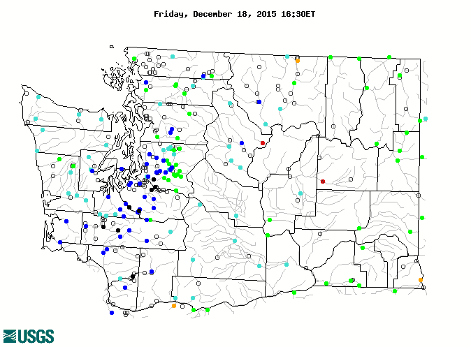
But what about streamline you ask?  Surely the rivers and streams are low in the supposed drought area.  Here is the latest.  Most rivers on both sides of the state are at or above normal.

What about snowpack?  There have been lots of scary stores about snow droughts for this winter and the like.  Most of the state has either near normal or above normal snowpack now, except a small portion of the western slopes of the Cascades.   There is no snow drought right now.


NOAA has an OBJECTIVE blend of short-term drought indicators (see below).  No drought.


What about the critical reservoirs of the Yakima River Basin, which supports a huge amount of agriculture in eastern WA?  As shown below, WAY above normal.

It seems to me that saying that any portion of Washington State is in drought is inaccurate.  Some groups are paradoxically calling this a wet drought.  Sort of like calling someone a thin fat person.  Some advocacy groups are using this term and claiming it may be a sign of global climate change.


This is not unlike some folks that were claiming that cold waves in the East Coast were the result of global warming.    Global warming is a serious issue and advocacy group antics with wet droughts and global warming fueled cold waves are not helping.  They detract from scientific credibility.

And this week I experienced the negative effects of Drought Monitor hype on scientific work.

For the past several days,  I have been at the American Geophysical Association (AGU) meeting and I have attended several sessions dealing with drought and hydrology.  One presentation attempted to verify their hydrological model against the official U.S. Drought Monitor, but found their objective model was much wetter.  You can guess why this is true.  The Drought Monitor exaggerates drought and does not pull areas from drought status fast enough.  And it is subjective and includes impacts.

GOOD NEWS ON KPLU

The University of Washington and Pacific Lutheran University have agreed to allow the community a chance to collect the funds needed to make KPLU an independen public radio station. They listened to the vast KPLU listenership, which was dismayed that a successful and valued local news and music outlet was being dismantled without public input.

There has been a lot of press coverage of this of late and detailed information at:  savekplu.org

Many of you are interested in contributing to building an independent KPLU.   It will take at least a few weeks before the mechanisms to do so are established, but in the meantime it would be very useful if you could express you interest in making a contribution and, if comfortable, estimate your future gift, by sending an email with the information to:

Grace Lynn Scott, KPLU's Gifts Coordinator at gracelynn@kplu.org

You can call her as well.

Should I Let AI Write My Blogs?

I spend a lot of time thinking about and writing my blogs.   Could AI apps do the work for me?   Could any of you tell the difference? Well,...