March 31, 2015

Seattle Turns White From Thunderhail

This afternoon Seattle turned white as thunder and lightning struck the Emerald City.

The thunderstorms were associated with the most pronounced Puget Sound convergence zone in a long time.   You remember the convergence zone, when northerly and southerly flow clash over Puget Sound producing clouds and precipitation?   Here is radar image at 4:46 PM, near the time of the big thunderstorm over Seattle.  The heaviest precipitation was associated with the red colors, which was associated with the pellet size small hail over the city.


Total precipitation from the convergence zone showers was respectable, with the Seattle RainWatch web site suggesting some locations got as much as 1-1.5 inches (see below).  The precipitation extended from the eastern slopes of the Olympics past the Cascade crest.

Snow even fell as low Snoqualmie Pass (see image)....enough to tease the skier but not help them.

But in Seattle the show was thrilling to the weather hungry in the populace. The small hail from the thunderstorm turned the ground white.


But the real thrill was the sound of the innumerable hail pellets striking the windows.   Click on the image below and enjoy.  A second video below that will add to your meteorological pleasure.


March 29, 2015

Will This Summer Be Warmer Than Normal?

I believe the probability of a warm summer in the Pacific Northwest is quite high.

Let me tell you why.

During the summer, high pressure builds offshore (the East Pacific High) and marine air from off the eastern Pacific Ocean slowly moves into the Pacific Northwest.  The temperature of the ocean surface is an important factor in controlling our surface air temperature (and dew point).

For many months, the sea surface temperature (SST)  of the eastern Pacific has been above normal and that is certainly true today.  Here is the sea surface temperature anomaly (difference from normal) for the past week.  You can see a huge area of warm water off the west coast of North America, with the water temperatures being 3-3.5 C  (5-6F) above normal.  There is no reason to suspect this warm water anomaly won't persist into the summer, and as the air moves over the warm water its temperaturs will be enhanced.

In fact, the latest runs of the NOAA Climate Forecast System (CFS) model suggests a continuation of the warm water off our coast into the summer.
Interestingly, if one plots the departure from normal of the Seattle temperatures for the last year one finds that nearly every day has been above normal (see below), with an average departure from normal of about 2C (3.6F), which is roughly the value of the sea surface temperature warming off our coast.  Really amazing how consistently warmer than normal we have been.


So the existence of the warm water alone suggests a warmer than normal summer.

But what does the NOAA CFS forecast for summer air temperatures look like?  Here is the answer for June-July and August.   Substantially warmer than normal!
But why depend on one seasonal forecasting system?   There is an International Multi-Model Ensemble (IMME) that combines the seasonal forecasts of the U.S. (NCEP), MeteoFrance, the European Center and the UKMET Office.   Here is the surface temperature anomaly forecast for the same period for IMME.  You guessed it....warmer than normal summer in our area.

The official NOAA seasonal  temperature probability forecast?  Warmer than normal over the Northwest, of course.

Seasonal forecasts have an imperfect track record, with some major busts in recent memory.  But making use of all the tools my profession has available, it does appear that the probabilities are strongly weighted towards another warm summer here in the Pacific Northwest.  I haven't discussed precipitation , but similar guidance does not suggest an usually wet or dry warm season.

What are the implications of the upcoming warm summer?  A longer hiking season for sure.  Increased chances of wildfires.  Higher summer humidity. A better beach season than normal. Another great tomato growing season.  Less chance of spring freezes in eastern Washington. And much more.  I enjoy a warmer summer even though it may not be politically correct to say it.


March 27, 2015

Watering In March

Yesterday, as temperatures surged into the lower 70s, I observed someone in my neighborhood watering their lawn.   So even with all the warm weather, should we be worried that our soil is already drying out?

But first, take a look at the amazingly warm temperatures on Thursday and keep in mind the average high on that date in Seattle is 55F!


Lots of 70s in western Washington and Oregon and 60s to the coast.

Although we have been MUCH warmer than normal, the precipitation has been close to normal for much of the winter.  Here is the % of normal for the last 30 days over Washington.  Wetter than normal over Puget Sound and MUCH wetter than normal over the NE Olympics and around Yakima.  A bit drier than normal in some other locations...but not by much.  No drought in Washington State.

So water is reaching the ground.  Warmer temperatures and more sun could mean more evaporation, but that is probably a small effect this time of the year.  But what does the U.S. drought center say?  

For example, they have a Crop Moisture Index (see below)...and that suggests that soils west of the Cascade crest are relatively moist (dark green).
The Palmer Drought Inde, which is more of a measure of long-term drought, is also wet over western Washington, but California is quite dry.
And it looks like we will receive enough moisture to keep the ground wet for a while.  Here is the forecast precipitation total for the next 72 hrs.  The Olympics and north Cascades will get plenty of water and southern BC will get hit fairly hard.


 My own personal experience is that here in Seattle one doesn't have to start watering until late May in dry years and late June in wet years.

So if you want dry, head to Yakima, eastern Oregon, or south.   And don't water your grass now....it doesn't need it.


March 24, 2015

The Most Unusual Weather This Winter. Normal Weather.

Light rain and a chill in the air.  Some snow accumulation in the mountains.  Towering cumulus clouds and showers.  It seems so strange.  Normal weather.

Here is a plot of the temperatures at Sea-Tac Airport for the past 12 weeks, with the normal high (red) and low (blue) temperatures shown.
During the last few days our average high and lows were near normal. Amazing.

The freezing level dropped below 3000 feet today and the  snow level dipped to around 1500 feet for a short time.   Imagine that.  Paradise, on Mount Rainier, received over half a foot before it warmed a bit.  Here is a shot there near sunset today.

The NW Avalanche Center even has a high avalanche danger out for tomorrow.   First one this year?
The NW Avalanche folks have had plenty of time to repair instruments and complete advanced training this year.

And take a look at the 500 hPa weather map for this morning.  A trough of low pressure over our region.  Haven't seen that in a while.


But don't worry, the ridge from hell (actually from the tropics) is coming back with a vengeance.

A strong WARM front is right offshore and will move in tonight.  To illustrate this, here is the forecast for 11 PM tonight of sea level pressure (solid lines), surface winds, and low-level temperatures.  Look along the coast.  You see the shift from SE to SW winds, a kink in the pressure lines, and a transition from cold (green) to warmer (yellow) temperatures...that is the warm front.

As the warm front passes, our region will be flooded by moisture, warm air and strong SW winds that will dump lots of precipitation tomorrow (Wednesday).  Here is the precipitation total for the 24h period ending 5 PM Wednesday.  Several inches of rain in the mountains on top of the snow today...that is why the NW Avalanche Center folks are worried.
Then...ready for warmth?  A big ridge develops over us on Thursday and we bake, with lowland temperatures near 70F that day.  Remember!  The sun is much stronger now.   As strong as mid-September.  Remember your sunglasses and sunscreen...you will need them.


March 22, 2015

Why has the weather been so unusual the past two winters?

After one of the warmest winters in Northwest history, a severely cold winter in the eastern U.S., and continued drought in California, the natural question is why.    Why have these conditions been present, with some subtle differences, during the past two winters?

As I have described in previous blogs (here and here), the proximate cause of the unusual weather has been a persistent ridge of high pressure (ridge) over the eastern Pacific and low pressure (trough) over the eastern U.S.  Let me give you a better view of this by showing you the anomalies (differences from climatology) of heights of the 500 hPa pressure surface (located at around 18,000 ft) for the last two winter seasons (Nov through Feb).  (see below)  You can think of 500 hPa height like pressure (higher heights mean higher pressure, etc.)  Blue colors indicate lower than normal heights (a.k.a., troughs) and yellow/orange suggest higher than normal heights (ridges).


You will note that both winters have a similar pattern with a line of alternating low and high pressures extending from near Hawaii to the north Atlantic.   This is called wave train and reflects a large scale atmospheric wave pattern emanating out of the tropics of the central Pacific.   Both winters (2013-2014, 2014-2015) have ridging over the West Coast and troughing over the eastern U.S., but if you look closely there has been a subtle eastward shift of the pattern.

 Last year's West Coast ridge was centered offshore and this year's ridge is nearly on the coast.  This subtle shift has had its effects, such as causing this winter to be warmer over our region, with a bit more precipitation over California.

So the question of why our weather has been so unusual is really about the upper level wave train:  why did it form?  Why so strong this year?  Why in in this configuration?

Fortunately, during the past few decades meteorologists have gained a deep knowledge of such wave trains, with much of the fundamental work done here at the University of Washington.

One early insight was that  large areas of convection (thunderstorms) in the tropic Pacific Ocean, generally located over warmer than normal water, could create an atmospheric wave train that moved into the midlatitudes.   You can think of the intense vertical motions in the tropical thunderstorms as big rocks dropped into a large (planetary) pond, with waves propagating away from the disturbed area (a young man below demonstrates this).


For example, we have learned when warm tropical Pacific waters shift eastward, with the big thunderstorms following---something known as El Nino---the changes in the position of the wave train greatly influence West Coast weather, causing low pressure over the eastern Pacific and wetter conditions over California.  Here are two plots:  one showing the sea surface temperature anomaly during El Nino years and the second, the associated impacts (anomalies from normal of the 500 hPa heights, again around 18,000 ft) over the entire globe.  The impact of the warm tropical water in the eastern Pacific are profound, including a deep low off (purple) of North America.  La Nina events (colder water in eastern Pacific, warmer in the west) have the opposite effects.
 El Nino and La Nina events (commonly called El Nino Southern Oscillation--ENSO--events) have demonstrated something profound to meteorologists:  that sea surface temperature anomalies (areas of warmer or colder than normal temperatures) in the tropical Pacific have a huge impact on weather in the midlatitudes.  Far more important than anything happening in the far smaller and less energetic polar regions.   To put it another way, the tropics are in the driver's seat when it comes to major circulation changes in the atmosphere.

So what does this have to do with the wacky weather of the past two winters?  Just about everything, as demonstrated by a series of recent research papers.

During the past two years there has been a sea surface temperature anomaly in the western tropical Pacific that strengthened and extended westward in 2015. Below are the sea surface temperature anomalies (difference from normal) for November to February of 2013-2014 and 2014-2015, with red and orange indicating much warmer than normal temperatures.  In 2014, you can see the warmer than normal temperatures near the equator NE of Australia (and the warm BLOB off our coast).   This year the warm waters extended eastward and the warm BLOB moved to our coast.


Several researchers, including Saeger et al and 
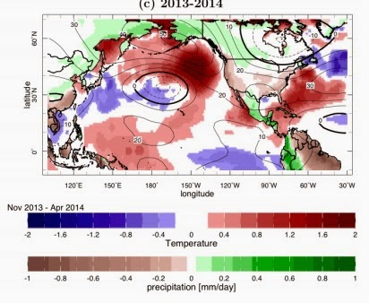
Hartmann 2015, to name just a few, have shown the including the observed tropical  sea surface temperatures in numerical simulation models produced midlatitude wave trains (positions of highs and lows) very similar to observed.  Here is an example from Seager et al., showing the winter 2013-2014 the sea surface temperatures anomalies (color shading over the oceans) used to forced the models.  In turn, the model produced dry conditions over the West Coast and an upper level ridge (shown at 200 hPa, around 40,000 ft) along and just offshore of the West Coast, with a trough over the eastern U.S.   Very similar to what was observed.  Magic.


The key point is that the observed sea surface temperature distribution in the tropics can forced the observed anomalous weather patterns in the midlatitudes.

Dennis Hartmann's 2015 paper demonstrates this pattern reflect a mode of natural variability called the North Pacific Mode.    The positive phase of the North Pacific Mode has a sea surface distribution very much what we have seen the past two years (see figure below, which shows sea surface temperature anomalies for NPM years)
Professor Hartmann analyzed the observed magnitude of this mode over the past several decades (shown below).  Note how it is has grown rapidly over the past two years.  But also observe that no long-term trend is apparent.   This suggests that the anomalous conditions are not reflecting global warming, which has revved up substantially over that period.


The bottom line of the bulk of the recent literature by top NOAA and university scientists is that the unusual conditions we have seen this year and last reflect natural variability, with much (but not all) of it associated with the North Pacific Mode.  Thus our unusual weather is probably not the result of anthropogenic global warming, and it appears that trendy theories of the impacts of polar warming are probably without merit.  The best news is that since it is natural variability one might expect that it will soon end.


March 20, 2015

First Day of Spring: A Very Warm Winter Ends

Spring began today at 3:45 PM PDT.  The fancy name?  The vernal equinox (vernal denotes spring, equinox indicates day and night are nearly equal in length).   At this time, sun is over the equator on its way northward (see figure) and daylight is nearly equal (12hr) over the entire globe.

Commenter tz0226 had a great suggestion--to look at the satellite image yesterday.  At the equinox the terminator (boundary between sun and darkness) is north-south (while it is tilted other times of the year except the autumnal equinox).   Here are visible satellite images from yesterday to show this from the NOAA GOES E and GOES W satellites.


But this is a special vernal equinox, the moon is new and there was a total solar eclipse today (not viewed here, but rather over northern Europe--see map)


So ends one of the warmest winters in Northwest history.

Let's take a look at the departure of the daily maximum temperature from normal over the past 90 days for the western U.S.  Amazing anomalies.  Much of northern Nevada and California, eastern Oregon and eastern Washington were over 6F above normal...some locations 8-10F above normal.  Western Oregon and Washington were 2-6F above normal during this winter.


The official 6-10 day outlook?  RED HOT!  While the poor devils back east stay in the cold and snow.
 The three-month outlook for April through June?  Red hot...well above normal along the coast.

For the fisherman in the community, what are the sea surface temperatures like?  A huge pool of warm water, 2-4 C above normal, along the entire West Coast.

Soil temperatures are far warmer than last year, with the 8 inch (deep) soil temperatures now getting into the 50s in parts of western and south-central Washington (see plot from the WSU AgWeather website). Seattle has soil temperatures 4F warmer than a year ago (54F today).   

Such warm temperatures means you can start planting some of the veggie seeds you normally wait until April to sow (e.g., parsley, onions).

Looking forward to getting out into the garden?  Sunday AM look dry, but rain will come in around lunch time.... nature will do the watering for you after you get your seeds in!


March 18, 2015

The most asked weather question, answered.

I get asked a lot of weather questions.  What do you think is the most frequent?  

No, its not about the impacts of global warming.

And what the probability of precipitation really means.

The most frequent question is:

What is the difference between partly cloudy and partly sunny? 

 Really, folks ask that all the time.  Sometimes it seems like a subtle put-down about meteorologists, but sometimes it reflects real curiosity.


Well, let's give the answer based on the official National Weather Service definitions.

There are two things you have to know about this.  First, different terms are used during the day and the night.   The National Weather Service (NWS) talks about clouds at night and sun during the day.  Why? Because there is no sun at night !   Second, the definitions are based on the percent coverage of the sky.    So let's examine what the NWS uses!  

At night, the sky goes from clear, to mostly clear, to partly cloudy, to mostly cloudy, and finally to cloudy as the sky coverage increases from 0 to 100%.   During the day, the descriptions go from sunny to mostly sunny to partly sunny to mostly cloudy (since you can't see the sun then!) to cloudy.  Here is a table with the exact definitions.

NIGHTTIME       DAYTIME         PERCENT OF SKY COVER

CLEAR           SUNNY           0 TO 5
 
MOSTLY CLEAR    SUNNY           6 TO 25

PARTLY CLOUDY   MOSTLY SUNNY    26 TO 50

MOSTLY CLOUDY   PARTLY SUNNY    51 TO 69

MOSTLY CLOUDY   MOSTLY CLOUDY   70 TO 87

CLOUDY          CLOUDY          88 TO 100

It all makes sense I guess.  And Pixar actually made a short movie in which the star is a lovable cloud called partly cloudy.   


March 16, 2015

Deluge and Divine Intervention

On Friday, Governor Inslee declared a drought emergency.   He is obviously a favorite of the weather gods...they have answered his plea.   Deluge.


You can tell that divine intervention was involved because the actual weather deviated greatly from the consensus of many of our best forecast models.  This is very unusual at such a short range.   A relief to forecasters, such as myself, who had worried that they had missed something.  

The weather supplications extended to the state legislature, which Governor Inslee called into special prayer session last Friday (see image below, video on TVW).  The rain priestess at the podium was from Bainbridge Island.


How much precipitation fell?  Here is the plot from Seattle RainWatch for the 48-h period ending 9 PM Sunday (there was even more after that!) for the area covered by the Camano Island radar. Two to three inches over the Sound and 4-5 inches over some of the foothills.   Even more near the Olympics.

Heavy rain forced the termination of skiing in Steven Pass...you have to respect the tenacity of those folks.   They never gave up.  You might want to buy one of their ski passes for next year.

And guess what?  Nearly two feet of of snow was dropped on top of the Olympics, while heavy rains were refilling the streams and moistening the soils (see graph for Hurricane Ridge).   A miracle.


And there is something else.  What day was it yesterday?  The Ides of March.  The Ides were sacred to the god Jupiter, also known as Jupiter Fluvius.  Rain was his specialty.  Governor Inslee knew this.

And his direct condition with powerful gods is reflected in the books he writes:


It is clear that the Governor has a deep connection with higher powers and surely many of you are hoping he will turn his supplications from the skies to a different direction.  A hint is found below:


Should I Let AI Write My Blogs?

I spend a lot of time thinking about and writing my blogs.   Could AI apps do the work for me?   Could any of you tell the difference? Well,...