February 27, 2018

Graupel Storm Hits Puget Sound

Sunday afternoon something strange hit the area between Seattle and Everett, from the Sound into the foothills.

A graupel storm.

Small white pellets starting coming down, first slowly and then in an immense wave in places, piling up until some locations had accumulated ..5 to 2 inches of the white balls.

Here is a nice video by Jamie D. that shows the fun:


Now some folks caled it hail and others thought it was sleet.  But it really is graupel, and  was caused by a strong Puget Sound Convergence Zone working on unstable air.

First, what is graupel?  This is what they look like close up.  White pellets.  Relatively soft.  Opaque.
 

Graupel is heavily rimed snow crystals.   Snow crystals form in clouds whose temperatures are generally cooler than about -15C.  At lower levels, where the temperature is warmer, but below 0C, there can be supercooled water (liquid water that is below freezing).

Some of the ice crystals fall into the supercooled water, where the supercooled water freezes on to the crystals in a process called riming.   The process is also known as accretion.  As the rimed particles get larger and heavier, they fall faster, gathering more supercooled droplets.   Finally, the heavily iced up particle---the graupel--reaches the surface. 
That is what happened Sunday afternoon.   The formation of graupel requires lots of supercooled water and that generally requires strong vertical motion, which is often associated with convection, towering cumulus and cumulonimbus being well known examples.  Convection occurs when the air is unstable and buoyant parcels of air ascend rapidly.

And everything was in place on Sunday afternoon.  A front went through that morning resulting in unstable air and cumulus convection moving into the area (see visible satellite image at 1 PM).   In the satellite image the convection is shown by the bright clouds, with dark spaces between them, coming in off the ocean.

At the same time, the wind were northwesterly on the coast, with air moving around the Olympics to the north and south, and then converging over Puget Sound--thus producing a Puget Sound Convergence Zone (see surface map at 3 PM).   As air converges together, it is forced to rise, which can really rev up clouds and precipitation, particularly when the air is unstable.


As a result, strong convection formed along the convergence zone between Seattle and Everett, something clearly shown by the radar image at 4 PM.


And that convection produced the graupel showers that caused the landscape to whiten.   Now to be clear, there was some snow mixed in at higher elevations and where the precipitation was heaviest, but graupel was dominant in most locations.

Finally, graupel is different than sleet or hail.  Sleet occurs when rain drops fall into a sub-freezing layer near the ground, resulting in freezing of the rain drops into little, hard ice pellets.  Sleet is generally dense and clear.   That is not what happened on Sunday.  And hail is multi-layered and dense, resulting from ice particles moving up and down several times in intense convection.   Not what we had two days ago.

Hail


February 25, 2018

Protecting Seattle From Extreme Weather

Although generally possessing a benign climate, Seattle does experience its own version of extreme weather that can takes lives and cause tens of millions of dollars of loss to the city.     Some of these threats will get worse under global warming and some will lessen in their impacts.


What are these weather threats and how can the city deal with them in the most effective way? 

So what are the extreme weather threats facing the city?

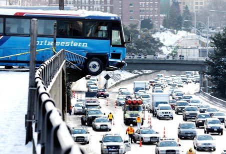
(1) The most costly one, although relatively infrequent, is snow and the impacts on the city's roadways.

For example, in 2008 a series of modest snow events, coupled with incompetent snow removal, crippled the city for several weeks.  Several people died, dozens, were injured, and the economic impacts were certainly in the hundreds of millions of dollars.  Snow events, and the associated cold weather, also have a heavy toll on the city's huge homeless population and several individuals die of hypothermia in every major cold/snow event.  And a previous mayor (Nickels) was removed for poor snow removal.


The snow/cold threat in the city should lessen in intensity during century since global warming will reduce its frequency.

(2)  The second most serious threat is heavy precipitation events.

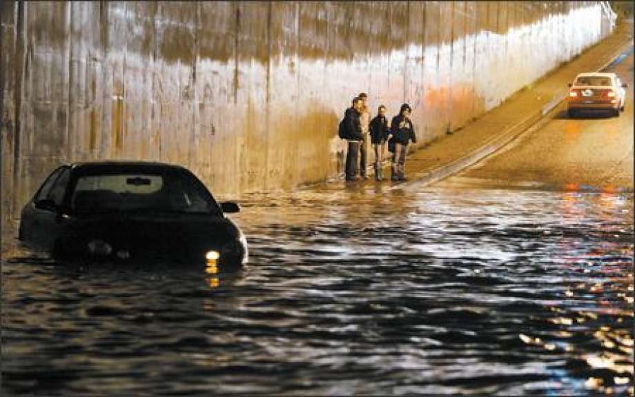
Ironically, for a fabled wet area, our infrastructure is not well equipped for short periods (hours to a day) of heavy rain.  An example of such heavy rain occurred on December 14, 2006, leading to street flooding and the tragic death of a woman in her basement.  Most of our heavy precipitation events are associated with strong atmospheric rivers, currents of warm and moisture extending out of the tropics.


Heavy rain on our poorly drained streets leads to hydroplaning and increases in accidents and traffic congestion.

Perhaps even more serious are the water pollution implications of heavy precipitation over the city.  Time after time heavy precipitation overwhelms our water treatment facilities resulting in massive releases of sewage and toxic chemicals into the Sound and Lake Washington.  Last year, the West Point sewage treatment plant was destroyed by a modest heavy precipitation event, not only seriously degrading the Sound, but costing over 50 million dollars of damage.

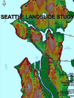
Heavy rain has another major impact on the city: promoting landslides and slope failures, particularly over the steep slopes overlooking Puget Sound and Elliot Bay.    Such slope failures not only close streets and damage/destroy homes, but often stop the Sounder (and other trains) coming in from the north.


The threat of heavy precipitation events and associated flooding, sewage releases, landslides will probably increase during this century, since there is a wide range of studies (including some done by myself and my students) showing that global warming will increase heavy daily precipitation events by 20-30% by the end of the century. 

(3)  Strong winds

Each year the Puget Sound region is struck by strong winds associated with powerful Pacific cyclones passing to the north of our area.  Each year, the city can expect at least a few storms with winds gusting to 40-50 mph, and every decade or so we get a major blow with winds gusting to 60-80 mph (e.g., the Inauguration Day Storm of 1993, the Chanukah Eve Storm of 2006).


These winds can cause extensive damage to the electrical system as tall trees and branches fall on to powerlines.  Unfortunately, such falling trees have frequently fallen on cars and individuals, causing loss of life and injury.    Strong winds can also cause localized flooding in locations such as West Seattle, and the temporary termination of ferry service.

The threat of such strong winds does NOT appear to be increasing and should not increase under global warming, a conclusion based on detailed modeling studies done by the UW for Seattle City Light.  Arctic warming actually reduces low-level temperature gradients reducing the "fuel" for these storms.


Occurrences of strong winds over Seattle based on high resolution real climate simulations

The last environmental threat from extreme weather is less serious.

(4) Air Quality

Seattle generally enjoys very clean air due to its proximity to the Pacific and Puget Sound and the generally onshore (westerly) winds that dominate western Washington.  As the plot below of small (PM2.5) particles show (for the Seattle Duwamish station for the past decade), there are two meteorological situations than can lead to short period of moderate air quality and potential impacts of vulnerable populations:

  • periods in the winter when high pressure and inversions are in place, a situation which increases the low-level concentrations of combustion products.
  • summer periods when wildfire snow over the eastern slopes of the Cascades gets blown over the city (like last summer).

Winter pollution levels are generally declining, as the use of wood burning stoves declined, good use of burn bans by local air quality agencies, and more homes using clean gas-burning fireplaces.  Long-term trends in smoke from eastern Washington fires is harder to predict since a major cause has been poor forest management, human fire initiation, and invasive flammable grasses.  Will those issues be dealt with? 

Warmer and drier summers may accompany global warming, and that could contribute to fire increases as well.  On the other hand, global warming should provide preferential heating east of the Cascades that will cause more of an onshore pressure gradient, resulting in more westerly winds (thus blowing the smoke away from Seattle).

So how can Seattle deal with extreme weather threats?

In the long term, making key infrastructure improvements (better waste water treatment facilities) and restricting development  (e.g., no building on steep slope) is needed.  But a huge amount is possible if city officials have the best possible guidance on extreme weather threats, which allows them to take steps to mitigate the risks.   And this is one area that the city and the UW have worked closely on during the past decade, and where substantial progress has been made.  Smart management of extreme weather allows protection of vulnerable populations and in preparing the city for active  and threatening weather.

Let me give you some examples of some operational systems that the city has in place.

WindWatch

Sponsored by Seattle City Light, this system (and website)  continuously monitors regional wind observations and several high-resolution weather models, telling City Light personnel when strong winds will occur or are occurring.  This allows City Light to bring in personnel and supplies before strong winds hit, thus allowing more rapid deployment and power restoration.    Notice how City Light gets the power on before PSE?  This is one reason why.

RainWatch

After the tragic death of a women in the Madison Valley in 2006, Seattle Public Utilities invested in the development of RainWatch, which constantly monitors the local weather radar and local precipitation gauges to determine whether heavy rain is occurring, or when certain precipitation thresholds are met.  It allows monitors high-resolution weather models for heavy precipitation events and warns SPU personnel when dangerous situations are imminent or occurring.  With this knowledge, SPU personnel can make strategic plans for water storage and the placement of personnel to deal with precipitation "hotspots."
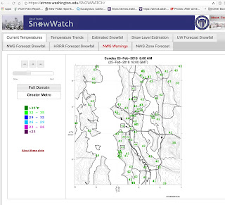
SnowWatch

SnowWatch is a highly sophisticated snow monitoring and prediction tool.  It monitors short and long-term weather prediction models for a snow threat, and gathers surface air and road-surface temperatures.  It checks the snow level aloft in real time.  Supported by Seattle DOT and Seattle Emergency Management, SnowWatch plays an important role in SDOT's management of Seattle's streets, including the pretreatment of streets with deicers, salt, and sand BEFORE snow strikes.   Seattle mayors like SnowWatch.


These three applications were created by Jeff Baars, a research meteorologist here in the UW Department of Atmospheric Sciences, and I have been involved as well.

Lately, we have been playing with a new concept, combining these extreme weather monitoring packages into one, with the addition of other guidance (e.g., landslide prediction, air quality monitoring, sea level monitoring).   Our first cut is below. Eventually, the monitoring could be combined into a one-stop monitoring page that would allow Seattle's emergency managers to review all threats with one glance.


Good monitoring and forecasting information is of substantial value in dealing with contemporary extreme weather and is the first line of defense for dealing with potentially escalating extremes in the future

February 23, 2018

Going to Snow Around Puget Sound Very Soon!

It is 1 PM and snow is heading towards Puget Sound during the next few hours.

Weather radar  (at 1:05 PM) shows a modest front, with associated precipitation, approaching  the coast (see image).

You can also see the front in the latest visible satellite imagery:


The air is PLENTY cold to snow.  The latest observations at SEA-TAC airport show the temperature is -10C at 850 hPa (about 5000 ft) and below freezing pretty much down to the surface (see temperatures and winds below in a time-height cross section)

And the air is quite dry.  That is important because precipitation falling into the cold air will evaporate (sublimate) and cool.

The only issue is how much.    There we have a problem for snow lovers in Seattle.  The winds are westerly/northwesterly approaching our region and this will result in a rainshadow (or in this case snowshadow) in the lee of the Olympics over central Puget Sound.

Our snow will be light....not much more than about a half-inch around Seattle, with more north and south.  Here is a forecast of the 24-h total precipitation (ending 4 AM Saturday).  You can see that pesky rain shadow.  There will be plenty of snow in the mountains, and several inches over parts of NW Washington.  The Kitsap will get several inches.


Anyway, a least the Seattle commute will not be too bad with the small amounts expected...but be careful in any case.

February 21, 2018

The Olympic Mountain Snow Shadow and Prospects for Snow this Week

Some light snow is falling over Seattle now, as a weak upper level disturbance moves though.  Perhaps a half-inch on the ground in North Seattle.

But in general, Seattle has been left out of the bounty, even though we are cold enough to snow.  More snow north, south, east and west of us.  But why are we being short changed?

There IS a reason.

Let's start by showing the distribution of snow depth tonight at 10 PM from the NOAA National Snow Analysis.   On the left, is last night and on the right, 10 days ago.

Quite a bit more over the west lowlands, particular south of Olympia, and east of the Cascade crest.  Very light amounts over Seattle and south King County.


A year ago? More snow than this year over the Oregon Cascades, less over the western lowlands and slightly more over the WA Cascades.

So why has snow been generally light or absent over central Puget Sound?

A major reason:  winds in the lower atmosphere have been too persistently out of the Northwest, leaving Seattle in the rain shadow of the Olympics.  To illustrate, here is the National Weather Service precipitation analysis for the last week....lots of precipitation in the mountains, but major rain shadowing over Puget Sound. And with cold air over us, that means snow shadowing as well.


Another issue is that the atmosphere is relatively dry west of an upper level ridge--and that is the pattern we have had for days (see map).


Only when a strong trough works its way around the ridge and drives southward can we get real snow in Seattle in such a situation.

Getting back to the current snow situation....snow should end during the next few hours as the upper trough moves by.  Thursday should be dry.

But we have another chance of snow on Friday, as two weak disturbances make their way south from SE Alaska to our region on Friday/Friday evening, and another on Sunday (see upper level maps for these times).


There is a good chance for light snow over the lowlands on Friday...and much more in the mountains.   Here is the European Center  high-resolution 24-h snow total forecast between 10 AM Friday and 10 AM Saturday. Over a foot in the mountains and about an inch in the lowlands.


In their ensemble (many model runs), the Seattle accumulated snow forecast starting 4 AM this (Wed) morning shows the light snow today (good prediction of about a a half inch), but more (about an inch) on Friday.  I should note that there is some uncertainty in the exact amounts, but some snow looks likely.

So at this point, no big snowstorm in view (at least through Saturday), but enough to think about getting that hot chocolate and enjoying the flakes.


February 19, 2018

Record Cold and the Northwest Stays in the Freezer for a While

The air over us now is unusually cold for this time of the year, in fact, record breaking cold in some ways.  For example, let's start with the temperature around 5000 ft (850 hPa pressure) at the radiosonde station at Quillayute, on the Washington Coast (see below).   In this plot, the blue line shows the daily record low 850 hPa temperatures.  Today's temperature (-12.5C, shown by a circle) was not only a record for the date, but the lowest for the surrounding dates as well.  Really unusually cold.

The surface air temperatures last night (see below) were held up by the windy conditions (which mix down warmer air above the surface) and some clouds, but still temps dropped into the mid 20s F in much of western Washington and single digits in the mountains  Some valley locations dropped below 0F.  Teens dominated in eastern WA.


Tonight is going to be much colder, with colder air aloft, clear skies, and less wind. The temperatures predicted for tomorrow morning suggest mid-20s in the west and single digits east of the Cascades, with some valleys in eastern WA dropping below -8F.


The latest forecast model output predicts another four days of the really cold stuff.  Here is the NWS GEFS ensemble forecast for Seattle.   Several more days of lows in the mid-20s ahead.


The large scale atmospheric pattern is really locked into a super La-Nina configuration with high pressure offshore and cool northerly flow over the NW.   To show you this, here are the upper level (500 hPa) weather maps for Wednesday and next Tuesday. Quite similar really.


There are occasional disturbances moving southward in to the flow east of the upper level ridge of high pressure that will bring some occasional precipitation, and in some places, snow.

To illustrate, here is the total snow fall forecast for the next 72 h.  Most of the snow is heading for Oregon and SW Washington.  None over Seattle or the WA Cascades.


The next 72 hour is quite different, with massive snows in the WA and Oregon Cascades. Skiers will be pleased.

Keep warm....

February 17, 2018

Wind, Snow, and Cold: Very Active Weather in the Northwest

This morning winds are gusting to 40 mph and more around the region (see max gust map below), with scattered power outages in Seattle and vicinity.


The reason?  A low pressure center is moving eastward to the north of Puget Sound, resulting in a large pressure gradient...and thus strong winds.


A strong front is associated with the low, and with powerful westerly winds aloft (some reaching 70-100 mph!), massive snow amounts are falling in the Cascades, with the big trouble in the passes (chains required and delays in Snoqualmie).

But this active weather is just a "warm up" for what is about to happen. (In fact, just the opposite of a warm up!).

Tonight and tomorrow morning,  modified arctic air is going to push in, with a huge pressure gradient down the Fraser River Valley, a conduit between the cold, high pressure in the BC interior and the warmer, lower pressure conditions in western Washington.    Very strong winds will exit the Fraser Valley producing gale-forced flow from north of Bellingham, across the San Juans, and towards the Olympic Peninsula (see forecast gusts at 8 AM tomorrow).  Wow.


The latest forecast model output suggests snow on the windward side of the Olympics and light snow even over Seattle as the leading edge of the cold northerlies push southward during the morning hours.  For Puget Sound residents, LIGHT is the operative word.

Here is the forecast 24-h snowfall (not accumulation) ending 4 PM Sunday.   Lots in the Cascades and less than an inch over parts of Puget Sound, with perhaps 1-2 inches in places south of Seattle. More snow over the San Juans.


But this is only one model forecast.  We should turn to ensembles (running many forecasts to judge our confidence in the snow prediction).   Here is a "plume diagram" showing 15 accumulated snow forecasts for Sea-Tac airport (time on the x axis and snow total on the y axis). A LOT of variation and thus uncertainty, with the ensemble mean being about half an inch.  The heaviest is 1.4 inches. 

But then cold air moves in and the skies clear...and the models are much more in agreement regarding temperature (see forecast below for Sea-Tac).  Dropping to the low 20s on Monday morning--and even colder away from the Sound.

Time to go outside and disconnect all hoses.    This will be coldest air we have had in over a year.

February 16, 2018

Cold and Snow

We are about to enter the coldest period in over a year (since December 2016 at least), with massive snow in the mountains and lowland snow in "favored" areas such as Northwest Washington and the northern slopes of the Olympics.  Even Seattle might get a dusting. I expect to break some daily low temperature records before it is over.

And if you don't want to support your local plumber, disconnect your outdoor hoses and protect exposed pipes.   And make sure your pets are warm.   Seattle will have to deal with its large homeless population, many of whom will be exposed to below-freezing temperatures for several days.

Let's start by looking at the 72hr snowfall forecast from 4 PM last night until 4 PM Sunday by the highest resolution model we run at the UW.  Two to three feet in the Cascade at the higher elevations of the Olympics.  With a low freezing/snow level, Snoqualmie Pass will get bountiful snow.  Just good news for skiers.  This snowfall will guarantee the rest of the season.


And here is a close up view of snowfall for the same period.  Note the snow around Port Angeles to Port Townsend!   This is due to upslope flow as air from the Fraser River valley jets out to the SW over Northwest Washington.

To illustrate this flow, here are the winds at 4 AM Sunday, showing winds from the Fraser Gap accelerating over the water and then heading toward the Olympics, with some of the cool air peeling southward towards Puget Sound.


You will notice the Puget Sound does not get a lot of snow.  The reason?  We are going to be heavily rainshadowed (snow shadowed) by the Olympics since the general flow is westerly/northwesterly.  But we do have a chance of a snowburst as the leading edge of the cold air from the Fraser (known as the "arctic front" in the business) moves through.  No more than an inch, though.

And then there is the cold air, which moves in Sunday and stays for several days.  Sunday night/Monday morning will bring temperatures dropping into the 20s in western WA and below zero to the higher terrain and eastern WA.   Here is the UW WRF model forecast for 4 AM Monday.  Twenties near Puget Sound and the water, dropping to the upper teens in the Cascade foothills and single digits and below over the Cascades and northeast Washington.   And it will be even cooler Tuesday morning.


The surface air temperature prediction for Tuesday morning is amazing cold, with temperatures below -8F pushing over much of the interior Northwest.   Even northern coastal California will get below freezing!


Stay warming...and be ready for unusually cold temperatures.

Should I Let AI Write My Blogs?

I spend a lot of time thinking about and writing my blogs.   Could AI apps do the work for me?   Could any of you tell the difference? Well,...