June 28, 2023

Is Washington State on Track for a Severe Fire Season?

Will the Northwest be the Epicenter of Wildfire This Year?

My friends at the Seattle Times are up to their wildfire dramatics again.

A front-page headline suggests that the Northwest will be the wildfire "epicenter" of the U.S.

and within the article, they claim that last year's Bolt Fire was a

"dress rehearsal for more frequent fires along the western flank of the Cascades as climate change drives warming summers"

So what do the actual facts say about the potential for wildfire activity this summer?  Is the scary hype based on reasonable science?   Is climate change/global warming behind the Bolt Fire and this summer's fires?

This blog will lay out some of the facts and give you a more nuanced and science-based view than you will get in the Seattle Times.

The Current Wildfire Statistics and Situation

So far, this has been a relatively normal to below-normal wildfire year in our region.  

Consider the latest wildfire statistics from the Washington State Department of Natural Resources (below).  These graphs are for Washington State and only for DNR lands, which are located mainly over the fire-prone lower elevations of the regional terrain.

We are running BELOW NORMAL for both fire numbers and fire area.

Next, let's turn to Northwest fire statistics from the Federal Northwest Interagency Coordination Center, which show that current fire numbers are near normal (blue line).  We were above normal in May and then fires dropped back during the moister weather of the past few weeks.

So far there have been very few forest burns.  Most of the fires have been grass/range fires, and that is certainly true of the larger fires.  

Why the significant grass/range fires?  

Because we had wet conditions last year that led to bountiful grass growth.   A great place to get information on this is the USDA FuelCast website.  Here is a figure from FuelCast showing the amount of dead fuel (mainly dried grasses, pounds per acre).  There is a major fire threat when this gets above roughly 800 lb per acre, which includes large swaths in eastern Washington.


Grasses dry quickly during early summer (even after rain, only a few hours will dry grass sufficiently to burn).

So we have a flammable threat east of the Cascades that has NOTHING to do with global warming.  It is from prior wet conditions, the opposite of global warming expectations.   All it takes is some careless ignition during windy conditions to burn a large swath of rangeland, and several such fires have already occurred this spring.

The Current Moisture Situation

We have had a persistent situation with near-normal moisture east of the Cascades (where most of the wildfires historically occur) and drier-than-normal conditions over western Washington.  The current National Drought Monitor graphic indicates this (see below)
Taking a broader, more objective view, is the latest Palmer Drought Severity Index, which combines the effects of BOTH temperature and precipitation.  Near normal conditions over eastern Washington and moister than normal over eastern Oregon.  Western Washington is drier than normal.


As I have mentioned in several blogs, the general atmospheric circulation over the West Coast has been highly anomalous this past spring, with a trough of low pressure over California.  This has dried out western Washington and Oregon while bringing wet conditions to California.

It has also brought persistent thunderstorms and rain over eastern Washington, which has lessened the wildfire threat there (see sample graphic below from the NWS).


As shown by the June rainfall map below, there has also been substantial precipitation over the Cascades, including the western slopes.


As a result of this precipitation and mild June temperatures (no major heatwaves), the fuel moisture around the region is not particularly low, and, in fact, moister than last year at this time.  And last year was a very low fire year, by the way.

To illustrate that the situation is better than last year, below is the 10-hr fuel moisture at Leecher, WA, not too far from Omak (2023 is on top, 2022 on the bottom)


So we have had a normal to below normal wildfire year so far, there is no drought over eastern Washington and Oregon, and fuel moisture levels are not particularly dry due to substantial rain east of the Cascades and the absence of major heatwaves.

Doesn't sound like a seriously threatening wildfire situation at this point, does it?

The national epicenter of wildfire disaster?

Looking Forward

Recently, West Coast weather has been dominated by troughing/low pressure over the Southwest US., bringing cool and moist conditions to California and lots of thunderstorms east of the Cascades (see upper-level (500 hPa pressure, about 18000 ft) map this morning to illustrate.  Blue indicates lower-than-normal pressures/heights


But this week there will be a major change, with a weak ridge of high pressure moving over the West Coast (the forecast for last Friday is shown below)


This pattern will be in place for much of the next week. We will warm a bit and the thunderstorms will fad back east of the Cascades.  As shown below, western Washington will warm into the mid-80s early next week.


This is not a situation that produces major heatwaves or strong winds. Surface fuels will dry out more and some grass fires could occur.

Importantly, many of the models predict a return of the West Coast trough situation, which would bring back the conditions we have enjoyed during the last week (see the upper-level forecast for the morning of Saturday, July 8).  Conditions that are not favorable for regional fire.


The bottom line of all this?  The wildfire situation now is pretty typical and there is no reason to predict a particularly severe summer wildfire season in the Northwest.   There will be wildfires, so folks need to be careful.

And one more thing.  The Seattle Times article stated that the Bolt Fire of last year was a "dress rehearsal" of the effects of climate change.

Simply wrong.  

Western Washington wildfires inevitably are associated with strong, easterly (from the east) winds occurring at the end of the (normally) dry summer.

The latest research (including material I have published) is that such winds will WEAKEN under global warming.  Also, let us not forget that the Bolt Fire was caused by an illicit fire and burned through a previously cut forest with lots of debris sitting on the forest floor.


June 25, 2023

Why Thunderstorms over the Cascades and Not Over the Lowlands?

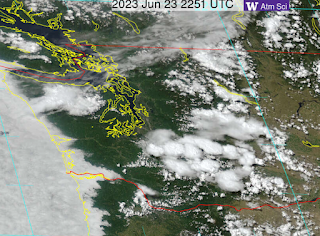
On Thursday, Friday, and Saturday of this week, we had a number of days with thunderstorms over the Cascades and Olympics, but little activity near sea level, something very obvious in a visible satellite image early Friday evening (see below)


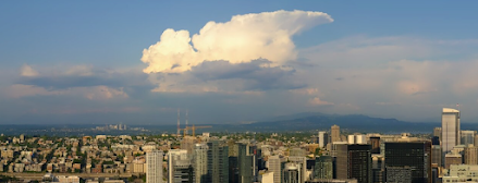
Friday evening, a Puget Sound resident could see a towering cumulonimbus over the Cascades, with a distinct cirrus anvil, something that is relatively rare around here:


And don't forget our ability to map every lightning stroke from the several lightning networks that sense the electromagnetic pulse from each stroke.  Here are the lightning strokes on Thursday--the preference for higher terrain is obvious.


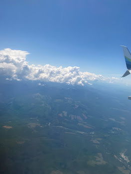
On Friday around noon, I was flying back from a meeting in Boulder, Colorado (at the National Center for Atmospheric Research) and I took some pictures of the developing cumulus clouds over the central Cascades (see below).

Flying near the Cascade crest (south of Snoqualmie Pass)

And then looking back from the lowlands, where it was clear.


So why are the mountains favored for thunderstorms and not the lowlands?

And why were mountain thunderstorms so active this week?

A key reason is that the air is more unstable over the mountains than over the lowlands.

Thunderstorms are a form of convection in which air parcels accelerate upwards.  A key requirement for convection is a large change in temperature in the vertical.  So cooling aloft or warming near the surface helps increase that vertical temperature change (gradient) that promotes convection.   You all have experience with convection when you heat up hot cereal, with rising currents of oatmeal occurring as the bottom of the saucepan is heated.


Over the mountains, the temperature change with height is greater because the mountains act as an elevated heat source (see schematic below). You can consider that the temperature is the same at a high level above both the mountains and lowlands, but the mountains act as a heater at some elevation (from solar warming during the day), squeezing the zone of temperature change into a narrower height range.  
That produces a larger temperature change (gradient) aloft that enhances the instability that revs up thunderstorms.  Meteorologists have a fancy measure of the instability called CAPE (Convection Available Potential Energy), and a map of CAPE on late Thursday afternoon (5 PM) confirms that it was more bountiful over the mountains than over the lowlands.


Thunderstorms are more frequent over mountains for another reason.  Upslope flow develops on the slopes during the day and such upslope flow converges at the top, producing a strong upward current of air that can promote cumulus clouds and thunderstorms (see plot).


Finally, why was this week so "favored" for mountain thunderstorms.   

We are now in early summer when the sun is able to effectively heat the mountain slopes.   Furthermore, the melting of the lower-elevation snow allows the ground to warm up in a way impossible during the cooler seasons.

But there is something else.  We have had cooler than normal air aloft associated with a cold, trough of low pressure (see 500 hPa map, about 18,000 ft) on Friday at 2 PM, below).  Green and blue colors indicate cooler temperatures.


The cold trough of low pressure will be hanging around during the next new days, so expect more mountain thunderstorms.  And don't expect any heatwaves in our future:  temperatures will be in the upper 70s for the next several days. 😋😀

June 22, 2023

The Forecast for the First Half of Summer

 Since summer just arrived, it is natural to examine the extended forecasts for the first portion of our warm season.

There is substantial forecast skill for the next ten days, particularly if one examines the ensemble of many predictions of the best forecasting system in the world:  the European Center.    

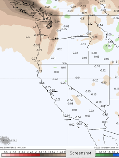
Below is the EC prediction for precipitation (the difference from normal) for the next 10 days. Drier than normal over western Washington, but near normal over California and east of the Cascade crest.   This is good:  the areas of historical wildfires expect to have near-normal precipitation.


For temperature, most of the West will be cooler than normal, except for western Washington and BC, as well as the Columbia Valley, with the warm areas of Washington being only modestly above normal.  We have seen a lot of this pattern during spring.


Turning to the longer time range, let's examine the international seasonal ensemble system combining many leading long-range models (IMME).   For July it is going for near-normal precipitation over the West Coast, and a bit wetter than normal over BC.

For temperature, IMME predicts California to be cooler than normal and Washington State slightly warmer than normal.

The official NOAA Climate Prediction Center long-range temperature forecast for July
is for near-normal conditions over most of the West, except for slightly warmer than normal temperatures over western Oregon and Washington.

Turning to July precipitation, conditions are predicted to be near normal along the West Coast.


The bottom line in all of this is that California looks to be generally cooler than through July-- helping keep the wildfire threat down there, particularly since it has been so wet over the Golden State. For Washington State, conditions look relatively close to normal, except for western Washington should be modestly warmer and drier than normal, during the month that is typically the driest of the year.

As I will describe in an upcoming blog, it is increasingly looking like this is going to be a relatively benign smoke year over the West Coast--with high confidence over the next month.   The wildfire threat is suppressed in BC and California.   The pattern of lower pressure (troughing) over the West Coast,  so dominant in spring, appears to be hanging around into summer.  And this pattern is not favorable for western wildfires.

__________________________________

Announcement

I will be giving a talk on the Weather of the western Cascade Foothills on Sunday, June 25th at the Sno-Valley Senior Center, 4610 Stephens Ave., Carnation, WA.  3-5 PM.  Open to all.  There is a sign-up link on Facebook:


The Weather of the Western Cascades w/ Cliff Mass | Facebook


June 20, 2023

Summer Solstice Snow and Cold over the Pacific Northwest

The summer solstice, when days are the longest of the year and the solar heating is greatest, will occur in less than 24 hours (7:57 AM PDT June 21).  But instead of enjoying the warmth of summer, our region is being buffeted by far cooler temperatures than normal, substantial precipitation, and snow at higher elevations (about roughly 4500 ft).  A number of daily low-temperature records will fall.

The solstice of snow.

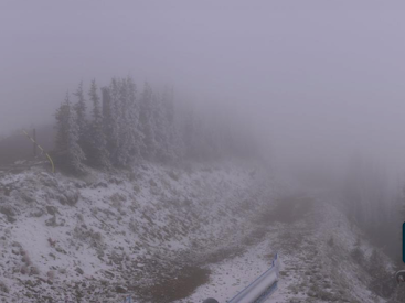
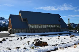
This morning's webcams at Paradise Ranger Station and Crystal Mountain show a blanket of fresh snow (Crystal Mountain cam image below).


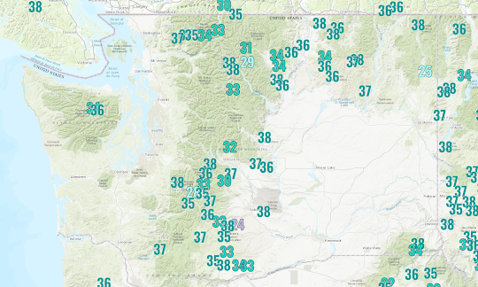
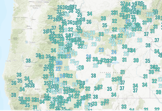
The low temperatures this morning were extraordinarily cold, with lows in the 30s over Washington State and 20s in Oregon (see low-temperature plots below).  The low temperatures in Oregon were very cold, with some locations dropping into the lower 20s.


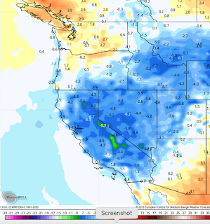
To get a better idea of how amazingly cold today will be, below is a plot of the predicted difference from normal surface temperatures at 5 PM PDT today.

The entire west is colder than normal, with startling frigid conditions over southeast Oregon, with temperatures over 20F colder than normal.  Eastern Washington is also amazingly cold.


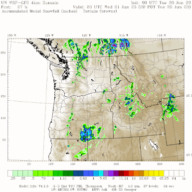
Consistent with the cold, the UW high-resolution model is forecasting snow around the region, with particularly heavy snow over southern BC and Alberta.  (The predicted snow total through 8 PM Tuesday is shown below).


Fortunately, the upper-level low-pressure trough associated with this cold weather is moving out on Wednesday, and substantially warmer temperatures will move in this week, producing near-ideal temperatures throughout the region.  To illustrate, below are the predicted temperatures at SeaTac, with highs in the 70s the entire week.   Very nice and no rain is predicted through the upcoming weekend.


The cold/wet weather has at least one major positive:   Northwest wildfires are running substantially below normal and the added moisture will substantially delay fires this summer.
__________________________________

Announcement

I will be giving a talk on the Weather of the western Cascade Foothills on Sunday, June 25th at the Sno-Valley Senior Center, 4610 Stephens Ave., Carnation, WA.  3-5 PM.  Open to all.  There is a sign-up link on Facebook:

The Weather of the Western Cascades w/ Cliff Mass | Facebook

June 18, 2023

The Real Story About a "Melting" Mount Rainier

As many readers of the blog know, I often provide a reality check for over-the-top and often inaccurate Seattle Times articles dealing with climate change. 

It is unfortunate that the Seattle Times has moved to an advocacy role on the issue of climate change, often exaggerating the effects of global warming.  They often fail to provide reliable information to their readers on this important topic.

In yesterday's online paper, they had a front-page story written by their columnist, Danny Westneat:  Mount Rainier is melting.  Can anything be done to stop it?

As you can imagine, they are talking about the glaciers on Mt. Rainier.  The story references a new "piercing" National Park Service report and talks about the substantial reduction in glacier ice volume. 

The message in the article is clear:  Rainier's glaciers are now rapidly retreating and that human CO2 emissions are the cause.   We need to act now.

"It’s climate change before your eyes." 

"We’ve really got to focus on how we emit carbon into the air.”

This is a very deceptive article designed to convince us that a signature aspect of our region is being lost due to human carbon emissions.

The truth is that Rainier's glacial melt has been predominantly natural, with human carbon emissions a small part of the story.

Although the story was supposedly motivated by a new report by Scott Beason and associates of the National Park Service (a very nice piece of work, I might add), this article NEVER mentions that most of the glacial loss on Rainier has little to do with human-caused climate change produced by increasing CO2, and the proof of this statement is found in the report itself.   

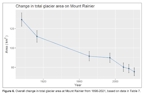
Consider Figure 6 of the report, which shows the change in glacial ice area on Mount Rainier since 1895 (below).  The glacial area has been reduced from around 130 km2 to around 75.   Note that most of the loss was between 1895 and 1970, a period when there was very little human-caused global warming.

Ice Volume shows the same story (see below)


Viewing the ice volume of Rainier's largest glacier (Emmons) shows that nearly ALL of the loss occurred during the 1895-1915 period.


There is, a large literature demonstrating the impacts of human greenhouse gas emissions is only significant after approximately 1980. Thus, the majority of the loss of Rainier's glacial ice had to be natural.

In fact, we have a good idea of what happened.  From roughly 1350 to 1850 AD, a large portion of the Northern Hemisphere was in the Little Ice Age, a period of cold temperatures and enhanced snowfall.  There are a variety of proposed mechanisms, including changes in solar radiation and shifts in ocean circulation, all caused by natural processes.  Starting during the late 1800s, the world and our region started to warm, and glaciers began to melt and retreat...as shown in the figure above.

Don't get me wrong:  global warming due to our emissions of greenhouse gases is slowly warming the planet and such warming would contribute to glacial melt during the past few decades.  But that contribution has been quite modest compared to natural variability, something that is not mentioned in the article.

But there is more.

The amount of warming that has occurred over Rainier (and our region in general) has been relatively small due to the presence of the Pacific Ocean, which has slowed regional warming considerably.  And this is particularly true of the windward (western) side of the Cascades, of which Rainier is a part.

We can show this explicitly using observations at Paradise on Mt. Rainier, located at roughly 5000 ft ASL.  Below is a plot of annual temperatures at Paradise from 1917 to 2022, covering the period following the end of the Little Ice Age.  

There is NO WARMING.  In fact, the trend line shows slight cooling.   This hardly suggests a major warming that would cause massive glacial melt.  There are periods of slightly warmer and cooler temperatures, but no overall trend.

I should note that there was little change in precipitation over the entire period at this location.


But let's take this one step further.  Glaciers are controlled by additions during the winter and melting during the summer, so let's look at the trend of summer (June, July, August) temperatures at the Paradise Ranger Station (below).   There is a small upward trend of roughly 1°F.   Less ocean influence during the summer.


The long-term perspective is critical for looking at such climatological data.  Imagine I plotted only the last 30 years of Rainier summer temperatures (see below).  

YIKES. Now the temperatures have warmed by 4F!    Folks would start to panic.


The Bottom Line

  A detailed look at the excellent National Park Service report and long-term glacial and meteorological data suggests the following story.

There has been a substantial loss of glacial area and mass on Mount Rainier during the past 130 years. 

Most of the loss has been natural and occurred before human-forced global warming could have been significant.

Mount Rainier, downstream of the slow-to-warm Pacific Ocean, has experienced very little warming over the entire year since the early part of the 20th century.   Summer warming has been weak over the past century, but there has been some short-term warming during the past decades.  

I believe a reasonable conclusion of all this is that most of the glacial loss on Rainier during the past century has been natural, but that human-caused warming could be making a modest contribution to glacial loss during the past few decades.

I wish Seattle Times reporters such as Danny Westneat would take the time to provide their readers a scientifically accurate, nuanced understanding of what is occurring.   And no, I don't think his idea of putting tarps or glass beads on the glacier is a good idea.

Finally, let me note that it SNOWED at Paradise this morning.  Mother Nature is telling us something.


June 15, 2023

Record Cold and Mountain Snow Ahead for the Pacific Northwest

Winter-like conditions will visit us over the weekend and into next week....so be prepared.

SNOW will hit the higher passes and elevations in the Cascades and other regional terrain, and a number of new daily cold records should be set at local stations.

Expect snow at Paradise, Mt. Rainier

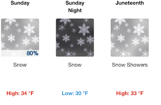
The National Weather Service's official forecast for the Paradise visitor center at Mt. Rainier is more reminiscent of winter than a late June forecast:
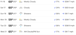
And the Seattle forecast of the Weather Channel (the best in the business) is going for a HIGH of 55F Sunday (with rain), a record low maximum temperature for that date, with 50s for both Monday and Tuesday.  Yikes.

Eastern Washington will cool down as well, with highs only reaching about 70F in the Tri-Cities.

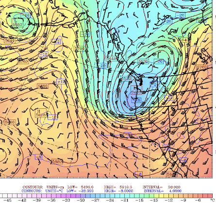
The unseasonal upcoming chilly, wet, and snowy period is associated with a strong, cold trough of low pressure moving into the region this weekend (check out the upper-level map (500 hPa, about 18,000 ft)  for 5 AM Monday).  The color shading shows the temperature:  blue is cold!  This trough hangs around in weakened form for all week!


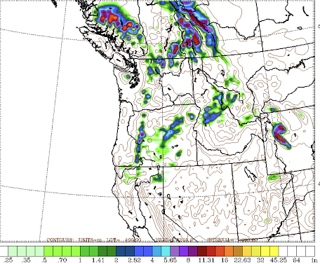
The predicted precipitation totals through Wednesday are shown below.  Wet over the entire region except for the rainshadow over the Columbia Basin.    Heavy precipitation over British Columbia, which will work strongly against wildfires there for many weeks.


The freezing level will drop to around 4500 ft on Sunday and as a result there will be snow in the higher passes and elevations (see snow totals below through Wednesday morning).  Higher terrain in the Cascades will get whitened, with relatively heavy snow in portions of BC and Alberta.


Daily low-temperature records will be broken.  Consider SeaTac Airport.  A plot of the lowest maximum temperatures for June 17-19 over the entire period (below) shows the record low maximum temperature for the historical period was 57F observed in 2022 and 2010.   
As noted above, the WeatherChannel is going for 55F, which would be a new cold record.  

There will be others as well.

This cold period follows the above-normal warmth of mid-May.   

The bottom line in all this is that if you want to enjoy Father's Day it might be best to move celebrations inside.   And I fear for the tomato plants in our garden...they will NOT be happy.

__________________________________

Announcement

I will be giving a talk on the Weather of the western Cascade Foothills on Sunday, June 25th at the Sno-Valley Senior Center, 4610 Stephens Ave., Carnation, WA.  3-5 PM.  Open to all.

Power Outage Prediction Maps for the Friday/Saturday Storm

6 PM.  Storm becoming more threatening to Seattle northward.  Update at 8:15 PM As a new service of this blog, I will indicate the areas whe...