May 30, 2022

Bad News. Clouds will Obscure the Meteors for Most of Washington State

I am disappointed.   It looks like clouds will make viewing of the meteor shower tonight impossible for most residents in Washington State.

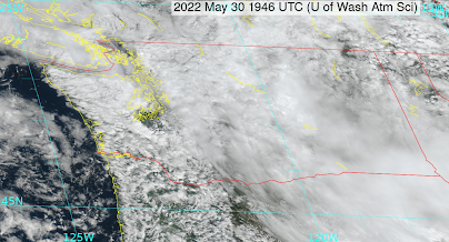
The lastest visible satellite image shows lots of clouds over the region.  But the real threats are the clouds stretching from the WA Cascade to the east.  High clouds that are moving westward over towards western WA.  There are lower clouds over NW Oregon...they will evaporate around sunset.


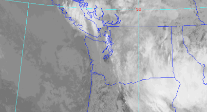
The infrared satellite image, which accentuates high clouds (white) show the problematic cloud field clearly.


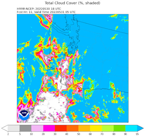
The very latest NOAA/NWS HRRR forecast of clouds at 10 PM tonight (the time of max meteors) shows 100% clouds (blue colors) over much of Washington, but low cloud cover over parts of western Oregon.   

Northwest Oregon is where you need to go if you are a serious meteor watcher.  And the further south you go, the earlier the sunset...another advantage!


The latest forecast of the NOAA/NWS National Blend of Models provides a similar story (see below).


Sorry to be the source of bad news..... I love astronomy and almost went that way for my career--so I am particularly unhappy to miss a potentially major meteor storm.

May 29, 2022

Warmth and Meteors Ahead!

 I am really looking forward to two events this week:   the potential for a meteor storm on Monday evening and the arrival of warmer than normal conditions on Tuesday and Wednesday.

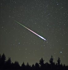
First, the meteors.   On Monday between 9:45 PM and 10:15 PM, the tau Herculid meteor shower will reach the earth.  There is considerable uncertainty on the number of meteors that will enter the earth's atmosphere, but it potentially could be a major event.

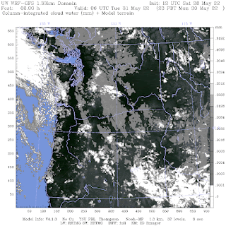
The latest high-resolution weather model output suggests that it may be clear or nearly clear over much of the Northwest (see cloud forecast map  for 11 PM below)


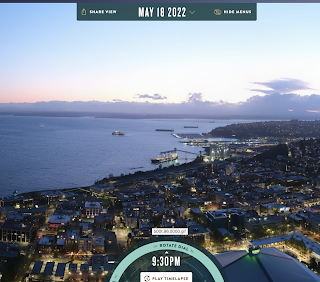
The other issue is moonlight and sunlight.  We will have a new moon....so no light there.  But there is an issue with sunlight.   Sunset is very late now (about 8:55 PM).   Civil Twilight ends around 9:36 PM--which is right before the meteor shower.  What does the end of civil twilight look like?  Here is the analog situation on May 18th for the sky at the start of the meteor shower:  too much light!  


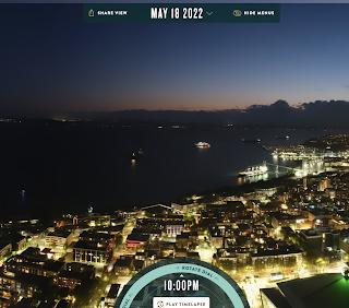
By the end of the shower (around 10:15 PM), it will look like this (see below).  Maybe we will have a chance then of seeing some meteors.


The "Heat Wave"

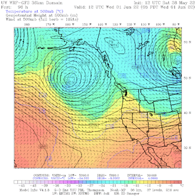
A ridge of high pressure aloft will develop over us starting late Monday and amplifying a bit on Tuesday and Wednesday (see upper-level map at 5 AM Wednesday below).


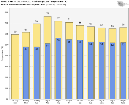
As a result, temperatures over the western lowlands will surge to around 70F on Tuesday and mid-70s on Wednesday (see the daily forecast by the skillful National Weather Service blend of models).  Unfortunately, we will descend into the murk later in the week.


The weather in eastern Washington will be far warmer, rising into the 80s for much of next week, and cooling will only be into the upper 70s.  


Keep your fingers crossed for an impressive meteor shower!

May 27, 2022

A Complex Memorial Day Weekend Forecast. Are These Weekends Getting Better or Worse?

 My podcast today (see below to access it), will describe the active and varied weather that will strike the region this weekend.   But there is more:  I will talk about the history of Memorial Day Weekend weather and how it represents a transition time into June Gloom.

A major feature this weekend is an unusually strong low-pressure center that will make landfall on the Oregon coast on Saturday afternoon (see below), with moderate rain extending over Oregon and powerful winds along the coast.   If you are vacationing in Oregon this weekend... sorry.

Surface weather map at 11 AM Saturday.

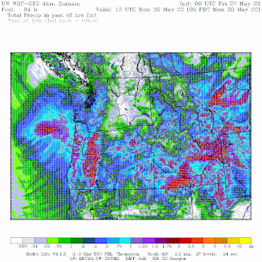
Precipitation will be bountiful over Oregon, as illustrated by the 48-h totals ending 5 AM Monday.  Oregon and northern Californa needs the moisture.


Monday will be much better.

My podcast also talks about the trends in Memorial Day Weekend weather.  Consider the precipitation at SeaTac Airport for the May 25-30th totals over the past 70 years. Not much of a trend, but it is clear that many such weekends are wet (and only about 10% dry).


Temperature?   Below are the maximum temperatures for Memorial Day Weekend in Seattle.  A lot of variability, but the trend is slightly DOWN.  Not much global warming signal so far.


To listen to my podcast, use the link below or access it through your favorite podcast service.


Some major podcast servers:

 HTML tutorial HTML tutorial
Like the podcast? Support on Patreon 


May 24, 2022

Wildfire Forecast for the Summer

Several people have asked me about the threat of wildfires for our region this summer.    

I have good news for them:  the wet/cool spring and other factors make a major wildfire season in Washington State highly unlikely.  That means less low-level smoke and other impacts.

Why are folks so nervous?   A major stimulus has been irresponsible media, such as the Seattle Times.

For example, Seattle Times cartoonist David Horsey published a recent cartoon showing Washington State on fire, with flames and smoke extending over the entire state (see my rendition of his cartoon below).

And ST's David Horsey doesn't stop there in inducing fear:

"That means another summer of wildfires. And that means smoke....there’s a good chance of that perfect August weather in Western Washington being smothered in an acrid cover of smoke blowing in from fires to the north, the east and the south."

As I will describe below, David Horsey and similar fearsters are ignoring science and data.

So let me explain why wildfires will be restrained this summer in our region.

Reason 1: An abnormally large snowpack.

    We are talking over 150% of normal! (see below).  As a result, the middle and upper slopes will melt out later than normal and the "fuels" will stay moist well into the summer, which delays the onset of wildfire season in the mountains.


Reason 2:  A cold, wet spring

This is important.  This year is a lot like 2011, whose summer had minimal local fire activity. 

To understand the situation, check the plot below of the number of acres burned each year over Washington State during the past two decades. 

There were more fires during the past decade than previously, which won't surprise any of you.  But look carefully.  There was one standout year for lots of fires (2015) and another with almost none:  2011.   The forests were not that different between the years--so what explains the huge variation?  

Below is a plot of the average temperatures in April and May for Washington State. 2011, the year with the least fires, had the coldest temperatures by far!  In contrast, 2015 was one of the warmest years.
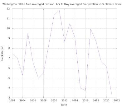
What about spring (April-May) precipitation?    2011 had the wettest spring during the period, while 2015 was very, very dry.


It all makes sense.  A cool, wet spring leads to fewer fires and a warm, dry spring leads to more fires.   Importantly, in both years,  springtime conditions continued into the summer.

So what kind of spring have we had this year?   

Extremely cool and wet like in 2011. Of course, May is not finished yet, but if we look at the last 60 days, the State has been hugely cooler than normal, particularly the fire-prone eastern part (see below).

Consider Wenatchee on the eastern side of the Cascades and near the eastern Washington fire area. For the period April 1-May 23, Wenatchee "enjoyed" the wettest year since 2011 (see below)


And Wenatchee has been COLDER this year than in 2011.


Seattle had the coldest year since 2011 (see below)


Take home message:  spring temperature/precipitation is correlated with summer wildfire area over the state, and this spring has brought very similar conditions (cool/wet) as experienced in 2011, whose summer had minimal wildfires.

Reason 3:  The extended model forecast indicates a cooler than normal June and normal precipitation.

The latest European Center extended forecast predicts a cooler than normal period through the end of June (see below, blue and green colors indicate below normal)


The total precipitation forecast for the next month (below) is very normal overall (and slightly wetter than normal over western Washington).  As an aside, the upcoming Memorial Day Weekend will be moist, with particularly heavy amounts in Oregon, where it is needed.


Obviously, a cool, moist June delays the fire season.

Reason 4:  A Strong La Nina Summer

There is a substantial impact of El Nino (warm tropical waters in the central/eastern Pacific) and La Nina (cool tropical waters) on the eastern Pacific sea surface temperatures and weather over our region.  And a significant wildfire influence as well.

The figure below shows the key index defining La Nina/El Nino for each three-month period since 2010.  This is the Nino3.4 index, with large negative values (-.5 and less--blue colors) associated with La Nina and larger positive values (+.5 or more-red colors) with El Nino. Based on the latest observations and model predictions, I have put in the expected value for this summer.

Note that the big fire year (2015) was associated with a strong El Nino and the low wildfire year (2011) with La Nina.  This makes sense: we tend to have cool, wet springs during La Nina years, with cool conditions extended into the summer.

This summer will have a La Nina as strong or stronger than 2011!


La Nina years are associated with cooler than normal northeast Pacific waters and that is exactly what is going on now (see sea surface temperature anomalies...difference from normal.  You see all the cold (blue) waters off our shore?


Since air moves eastward from the Pacific into our region, this implies a cooling effect for this summer.

Reason 5:   Much of the Vulnerable Forests in Our Region Have Already Burned

We have had a lot of fires during the past decade, as the poor forest management of the past century has caught up to us.  By suppressing fire and allowing a dense, unhealthy forest to develop, we created a tinderbox in which large, catastrophic fires have occurred.

There is substantial scientific literature demonstrating that the passage of fire through a region suppresses future fires for a decade or so.    Thus, with so much burned during the past decade, there are fewer fuels available today.   This is a fact that few in the media have talked about:  fire makes more fire LESS likely in the short term.

To illustrate the situation, take a look at the burned area of north-central Washington from 1985 through 2020, as shown by a graphic from the marvelous wildfire explorer website (thank you to Dr. Susan Pritchard for pointing this out to me).  The colors indicate burn severity.

A huge proportion of the area has already burned and is thus LESS likely to burn today.


Reason 5:  The Fuels are Unusually Moist

Fires need "fuels", such as dried grass, downed trees or slash, and the like.  Moist fuels prevent or restrain fires.  And because of our wet, cool spring, the fuels in nearby forest are unusually moisture-bound.  

Consider the 1000-hr dead fuels (branches and the like of 3-8 inch diameter) for the critical eastern slopes of the Cascades and the Okanogan region to the north.  When we get smoke in Seattle, the fires are generally in this region.   

The graphics below are from the Northwest Fire Coordination Center.  The red values are observed fuel moisture levels, and the central line surrounded by gray are the average values.  The top and bottom lines are observed extreme values and the gray area includes observations within two-thirds of the mean moisture. 

Region 6 encompasses the Washington Cascades' eastern slopes and region 8 is the Okanogan area.  Wow.   The moisture content in both areas is well above normal...nearly a record high.  This stuff is not going to burn very soon!
California smoke?

The situation in California is very different from that in the Northwest.  They have been much drier than normal this past winter and thus CA fuels are primed to burn early.   There will be significant fires over the Golden State this summer, with the only good news being that the dry winter/spring will result in less flammable grass.

California fires rarely produce lowland smoke over Washington State, since any smoke that reaches us tends to stay high.   We may have some haze, but little air quality impact occurs near the surface.

To get lowland smoke over Washington the fires need to be close:  either over Washington or the adjacent areas of BC or Oregon. 

California Smoke Moving Northward in 2018

In summary

Actual data and historical wildfire information suggest a very benign local fire season in and near Washington State.  Could we have a big fire if the meteorological conditions come together later this summer?  Yes.  But it is clear that the meteorological situation is not favorable for wildfire.

If things work out as the data suggests, I hope Mr. Horsey and the Seattle Times will consider the following idea for a cartoon later this summer when the smoky future they predicted does not materialize.


May 22, 2022

Lightning Fest over the Northwest

Thunder was heard all over the Northwest on Saturday, including many areas without a drop of rain.

Take a look at the lightning strike map for Saturday. Quite a few lightning strokes over the western slopes of the Cascades and Rockies....and a number of boomers moved over southeast Washington.  


Yesterday morning one could see the cumulus convection start to pop up over the Cascades, and by early afternoon (2 PM for the Seattle Panocam shown below) there was fairly deep convection (the meteorological term for cumulus clouds) with prominent cirrus anvils.  


I was taking a walk with Steve Pool, the retired KOMO TV meteorologist about this time,  and we were admiring the huge cumulus over the mountains.

The cumulonimbus producing the lightning had enough precipitation that the weather radar "lit up" over the region, something illustrated by the regional weather radar around 2 PM (see below).  Many of the showers formed initially over terrain and then drifted off.


For example, some of the convection over the Cascades drifted west during the afternoon, with one getting as far as Bellevue.   

Take a look at the PanoCam shot looking northeast from Seattle around 6:30 PM.  You can see a shaft of rain reaching the surface!  This cell produced thunder, which was heard all over Seattle.


The cumulus convection was very apparent in the visible satellite imagery, as illustrated by the image around 2 PM (see below).  I put in an arrow to indicate one of the cumulus cells. 


How much rain fell during these showers?  The answer is below (the rainfall for the entire day is shown).  Much of the Cascades and eastern Washington got some light rain (.01 to .1 inch), with a few lucky regions getting half an inch or more.  The showers will help keep the soil moisture up in eastern WA.


Now you may ask: why did we get these showers and why were the mountain slopes favored?    Good question

There are two main reasons.   The air over us yesterday was colder than normal (surprise, surprise), while the sun has become powerful, strongly warming the surface.

The combination of warm air near the surface and cool air aloft produces a large decline in temperature with height (called a lapse rate).....and large lapse rates foster atmosphere convection, where the atmosphere starts to percolate.  

A sign of the potential for instability is something called Convective Available Potential Energy (CAPE), and as shown by the figure below, the values were relatively high for our region (as high as 500!)


And there was something else.  An upper-level trough of low pressure was over us (see the 500 hPa--about 18,0000 ft--upper-level map below), and such features produce upward motion that encourages cumulus convection.


But why were many of the thunderstorms initiated over the mountains?   Because mountains provide additional upward motion that helps give the upward moving air a jump start!


Today the thunderstorms will be absent from the region--so enjoy. 

   And better enjoy this weekend.   Memorial Day weekend is going to be memorable...but NOT for nice weather.

May 20, 2022

The Best Weekend in a While, Plus Why Eastern Washington is NOT in a Drought

My new podcast is out.

I start with a very favorable weekend forecast for most of the region, with warm, dry conditions over the lowlands of western and eastern Washington.

Only the mountains may get some showers on Saturday.

And then I take on the exaggerated claims of drought in eastern Washington.

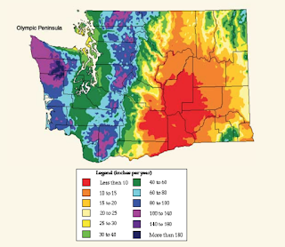
I start by referring to the climatological precipitation map of Washington, noting that much of the Columbia Basin is desert, with less than 10 inches a year.  

Only with irrigation is agriculture possible and a small shortfall of precipitation is meaningless.  

In the podcast, I review the favorable water situation that is now occurring and will be present throughout the summer for eastern Washington, with little negative impact expected on agriculture.

Bottom line:  there is no drought in eastern Washington, by any relevant measure.

To listen to my podcast, use the link below or access it through your favorite podcast service.


Some major podcast servers:

 HTML tutorial HTML tutorial
Like the podcast? Support on Patreon 


Should I Let AI Write My Blogs?

I spend a lot of time thinking about and writing my blogs.   Could AI apps do the work for me?   Could any of you tell the difference? Well,...