This is NOT going to be an historic heat wave west of the Cascades...but we could well break a daily high temperature record on Monday. So don't expect the high 90s, with peaks about 100F, that we experienced in late July 2009. And there is a chance of some major thunderstorms...but just a chance.
So why will this event be modest? The reason is that the set-up is not correct for one of the big events, because the low-level pressure distribution will be wrong and we won't have sustained offshore flow. Specifically, to get a big heat wave west of the Cascades, we need the upper-level ridge (high pressure) right over us and low-level high pressure to OUR EAST, which encourages offshore flow.
Here is the latest WRF forecasts for the upper air (500 hPa) and sea level pressure (and lower atmosphere temperatures) for Monday at 5 PM. The upper level ridge is centered over Idaho and there is lower pressure over eastern Oregon. There is a hint of a weak thermal trough over the Cascades, but some of that is bogus for reasons I won't get into here. There is on onshore pressure gradient (difference) west of the Cascades, which allows marine air to seep in.


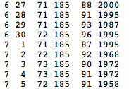
Will any records be broken? Well, for Seattle Tacoma Airport I suspect the daily record will fall on Monday. As shown below (look at the second to last column), the record high for Monday is 87F...we have a good chance of exceeding that.
There will be surge of offshore flow near crest level of the Cascades that should result in the highest temperatures that day and Tuesday, but then the pattern will shift subtly after that as a weak system approaches from the west. The result will be increased onshore flow and slow cooling. Into the lower 80s on Wed. and 70s on Thursday, with the return of morning low clouds.
For me a very interesting aspect of this event is the development of very high instability in the lower atmosphere, instability that can lead to thunderstorms. A key measure of the potential thunderstorm "juice" is something called CAPE (Convective Available Potential Energy). Here is the plot for Monday at 5 PM. I don't think I have ever seen such high values here in the NW...reaching 2500-3000. High for us is usually in the few hundred.


One more thing...does it feel unusually humid outside....reminiscent of the eastern U.S.? Well, it is! Check out the latest dew point temperatures, shown below. (Note dew point is a good measure of the amount of moisture in the air. Starts feeling sticky in the 60s).
Lots of values in the 60s, some in the upper 60s...this is relatively unusual around here and it occurring because today is warming up substantially with a lot of recent rains and wet ground. All the water is evaporating into the air.


Just as you made this post, the latest EURO really flipped in one model run for the medium forecast range. Cuts the base or energy off the trough offshore, potentially leaving us in a flatter, not as hot, stable conditions. More typical for this time of year.
ReplyDeleteActually, extremely hot temps are NOT good for eastern WA viticulture. Most vines enter dehydration survival mode at around 95° depending on variety and the stomata close, terminating photosynthesis.
ReplyDeleteHey, Cliff, somewhat off-topic, but why would the temperature drop six degrees in five minutes in Death Valley (Furnace Creek)? Between 7:15 a.m. and 7:20 a.m. on June 26, the temperature dropped from 99 to 93. Maybe you can explain this.
ReplyDeletehttp://www.wrh.noaa.gov/mesowest/getobext.php?wfo=vef&sid=ISWC1&num=72&raw=0
It's absolutely scorching. It's 10:15PM right now on the Sammamish plateau and it's 88F and 48% humidity.
ReplyDelete