May 31, 2024

Flooding of the Snoqualmie River and Record Rainfall

 We are about to begin a historic rain event, with the one or two-day rainfall being in the top five of the historical record over Puget Sound.  Some other locations we do even better.

Impressively, the Snoqualmie River is predicted to flood with record-breaking flows for any day in late May or the first half of June.

The rain will start mid-day on Sunday and it will go on for several days.

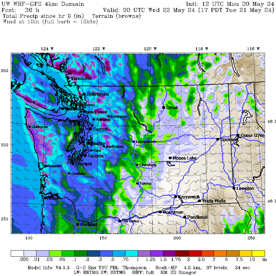
Let's start with the predicted total precipitation through Tuesday morning (below).  Just wow...much of our mountain areas will receive over 3 inches, with limited areas getting over 5 inches.

An extraordinarily intense atmospheric river, one quite rare for early June, will slam into the region.  The water vapor transport map for Sunday afternoon illustrates this (see below).  This would be impressive in November.  In June, startling.


Shockingly, this plume of moisture can be traced all the way back to southeast Asia!! (see map below for the same time).  Another Chinese import (😃).


The sustained heavy rain is predicted to take the Snoqualmie River to flood stage--and the highest level ever observed this time of the year (see plot below from the NOAA/NWS Portland River Forecast Center).  The orange line shows flood level and the upturned red arrows show the highest historical levels for each day.


How unusual is the event?  

Below are the top ten precipitation values for SeaTac for the first half of June.  The current predicted two-day total at that location is about 1.5 inches, so could enjoy the third or fourth wettest totals since 1945,

Keep dry!

_____________________________________

Announcements

I will be doing a podcast about the event later today.

I will be teaching ATMS 101 this fall--the introductory atmospheric sciences class.

The class will be BOTH in person at the UW and available over Zoom.  Thus, folks can take it remotely.

If you are over 60, you can take the class through the ACCESS program for a very nominal charge (something like $20).   During the past few years, several hundred have done so. 

So if you are a UW student looking to learn about weather or a non-student interested in the topic, I welcome you to join me this fall.  


May 29, 2024

Heavy Precipitation Event with Record River Levels

An extraordinarily heavy precipitation event for early June will occur next week, with daily rainfall records falling and many regional rivers hitting record levels for June.

Rain so heavy that the wildfire threat will be greatly diminished for an extended period and regional reservoirs will get a mighty "top off" before our normally dry summer season.

Let me show you the latest forecasts, and be prepared to be amazed by the soggy bounty ahead.

Consider the latest European Center accumulated precipitation forecast for their model run starting 5 AM this morning (below).

The total through 5 PM today (Wednesday) is wet enough, particularly on the western side of Cascades where as much as an inch should fall.


With more showers on Saturday, the totals become more substantial over Northwest Washington.


But you haven't seen anything yet.   A very moist atmospheric river comes in on Sunday/early Monday and precipitation totals go crazy, with 2-4 inches on the western slopes of the regional mountains.

The totals by Wednesday morning are staggering, with some favored locations getting to 4-6 inches of rain.  This is unusual for June, to put in mildly.


Even in rain-shadowed Seattle, the ensemble forecast of many simulations suggests we will receive about 2.5 inches (blue and black lines are the ones to look at). 
Much more than the average TOTAL rainfall for the ENTIRE MONTH OF JUNE here in Seattle (1.42 inches)

Such heavy precipitation will saturate the regional soils and cause rivers to rise rapidly, with the NOAA/NWS River Forecasting Center (RFC) predicting a rapid rise to action levels and the exceedance of the previous daily records (red up arrows).


Most impressive of all is that this heavy precipitation period is associated with multiple strong atmospheric rivers.  To illustrate, below are plots of water vapor transport, the best measure of atmospheric river activity.  Blue colors are very high.

Sunday night at 8 PM an amazingly strong river heads across the Pacific and then slams into our region.


On Tuesday morning, ANOTHER river plows into the Northwest.  Really unusual for June.


Expect many precipitation records to be broken.


May 27, 2024

Is Global Warming Causing Aircraft Turbulence to Increase?

 After the turbulence encounter by a Singapore Airlines aircraft,  there has been a slew of articles claiming that severe turbulence incidents are rapidly increasing due to global warming.  The articles below in the Seattle Times and on the BBC are just two of hundreds of such stories


Several stories have been quite specific stating that turbulence has increased 55% in 50 years, based on a study by investigators at the University of Reading.


Is any of this true?   As I will describe below, there are substantial problems with these apocalyptic claims of radically more bumpy skies.

But before we discuss these turbulence claims, keep in mind that aircraft turbulence can be caused by several different mechanisms, and not all of them are related to changes in climate.

Much of the turbulence is due to convection associated with big cumulus clouds, like cumulonimbus, which produce thunderstorms. The turbulence on the Singapore Airlines flight was associated with tropical convection.


Other turbulence is associated with high-amplitude atmospheric waves associated with mountains (see figure).  Such turbulence is often observed downstream of major mountain barriers such as the Rockies and the Sierra Nevada.

Source: Whiteman (2000)

There is also turbulence associated with vertical wind shear:  if wind speed changes rapidly with height, the atmosphere can break down into turbulence eddies.  This kind of turbulence often occurs without clouds and thus is often called clear air turbulence and is generally the least severe of the major turbulence mechanisms.  Finally, it is possible to get turbulence near the surface, called mechanical turbulence, as air passes around objects.

How frequent are the different sources of turbulence?  The best records and observations are found in the United States and the contributions of various types of turbulence by month are shown below (from an FAA document) for 2009-2018.  

Convective turbulence is number one and dominates in spring and summer. Clear air or shear turbulence is number two and is most dominant during the cool season.


Is turbulence increasing rapidly over time as suggested by the media headlines?  

FAA records don't seem to suggest this.  Below is a graph showing the percentage of aircraft incidents/accidents caused by turbulence (dark line).   No increasing trend since the late 1980s!


So where are all these dramatic claims for increasing turbulence with global warming coming from?  

Answer:  from a handful of papers from one group at the University of Reading.  The key paper is here.


In this paper, they DON'T USE ANY TURBULENCE OBSERVATIONS.  Rather, they use analysis of weather data on a grid (called a reanalysis) and use a theoretical model that they suggest should indicate shear-forced turbulence.   But they really don't have the data to back this up or to demonstrate their approach is reliable.  

Even more problematic, the 55% increase in turbulence they cite is NOT for the entire world but just for one region in the North Atlantic.    If you read the actual paper (I have), there are all kinds of qualifiers that never made it into media stories.

To gain some perspective, their 55% increase in this one location represents an increase from 17.7 to 27.4h PER YEAR. Ten hours more a year is 0.0011 of a year.   For the least severe source of aircraft turbulence (vertical wind shear).

 The media did not tell you that the increase was so minor. Still worried?  And that paper said nothing about the other sources of strong turbulence, which in total are more important than the shear-induced, clear-air turbulence they considered.

And there are other technical problems with the above paper that could be a real problem.  For example,  the weather observational system has been greatly expanded and enhanced over the past 40 years, allowing observations to far better define atmospheric structures that can produce turbulence.  Massive additions of satellite data and aircraft observations have occurred during the period in which the Reading group claimed the threat was increasing the most.  Was the threat really increasing or was our ability to define strong wind shear layers getting better.  They didn't say.

In summary, I believe there are no reliable studies that indicate a substantial increase in aircraft turbulence due to changing climate conditions.  The media is needlessly causing folks to worry about flying. 


May 25, 2024

New Podcast: Memorial Day Weekend Forecast and More on Western Washington Wildfires

This weekend will be a mixed bag west of the Cascade Crest but warm over eastern Washington. 

The predicted high temperatures for the next few days are shown below.  Today (Saturday) will be cool in the west, frigid in the mountains, and comfortable in the Columbia Basin.


Sunday says cool in the west, while eastern Washington warms considerably.


Monday is the best day.  Decent over the western lowlands, warm enough for hiking in the Cascades, and downright warm in eastern Washington.


I talk about the forecast in some detail in my podcast (see below), and discuss the apocryphal forecasts of enhanced western Washington wildfire threats this summer.

You can listen to the podcast below or through your favorite podcast server.


Some major podcast servers:

 HTML tutorial HTML tutorial

May 23, 2024

More Wildfire Misinformation at the Seattle Times

 The Seattle Times continues to shamelessly exaggerate and hype the regional effects of climate change.

This week they really went overboard regarding wildfire.

Yesterday's front page features a large banner headline stating that western Washington faces an above-normal risk of wildfire.


Why?  They claim because of low snowpack and precipitation.

The truth is that there is no reason to expect an above-normal wildfire season in western Washington this summer.  Let me tell you about the situation and note that I am writing a paper on this topic (the meteorology of westside wildfires) for my real day job.

Wildfires in western Washington require very different conditions than wildfires in the interior of the Northwest.  Specifically, to get a major wildfire over the wet/cool westside requires strong easterly (from the east flow).

Major western Washington wildfires are rare because the region is moist and dominated by cool, moist maritime air.  

Strong easterly flow pushes out the marine air and causes warming and drying as the air sinks down the western slopes of the Cascades and Olympics.  And this strong easterly flow has to occur in a very limited time window when the fuels are dry enough to burn:  essentially late  August and the first half of September.

The last major westside wildfire was in September 1951 on the northwest side of the Olympic Mountains near Forks (about 33,000 acres).  Strong northeasterly winds were observed.  There have been a few smaller western Washington wildfires (again with strong easterly flow) such as the Bolt Creek Fire (15, 000 acres in September 2022).  There is no increasing trend of such fires.

I read this book last week

Snowpack has very little correlation with western Washington fires because such fires are generally at lower elevations where the snow melts out early even in normal years...and again, these fires don't happen until late summer anyway.

If the easterly winds occur, a hot/dry late summer helps, but at this point there is no reason to expect unusual summer conditions.  El Nino is gone and this summer we will be transitioning to La Nina.  In any case, the correlation of El Nino/La Nina with our summer weather is very weak.  Furthermore, May is turning out to be seasonally wet and cool.

Importantly, there is no reason to expect an increased probability of an unusually strong easterly wind event this summer.  None.  

In fact, the latest European Center pressure prediction for September (the big easterly wind month), is for higher than normal pressure offshore, which WEAKENS easterly flow (see below).


And if the above front-page article is not scary enough, the Seattle Times had a hyped-up opinion piece about the wildfire season now becoming everywhere all the time.   


It even included the claim that:

In fact, it’s getting to the point that wildfire season is all year long.

Do you know how many wildfires are burning over Washington State and adjacent areas now?  Zero.  See proof below.


The article notes there are some fires in Canada, BUT THAT IS TYPICAL for the Boreal Forests.

For those of you worried about wildfire, guess what the forecast is for the next few days?

A nice wetting rain  over western Washington (see below, through Sunday morning)


And then EVEN MORE rain is predicted new week (see ensemble of many precipitation forecasts over Seattle).


Finally, today I was sent the most wonderful video of the aurora, with a background of triumphal music (see below).  Created by 
Bart Durbin. 

Be prepared to be emotionally affected.   Bart did a wonderful job creating this.


May 21, 2024

What Caused the Severe Turbulence on a Singapore Airlines Flight Last Night?

 The media is full of stories about a terrible turbulence event on a Singapore Airlines flight from  London to Singapore last night.  One person was killed and dozens were injured.

The event occurred over the water offshore of Myanmar (the location shown on the map below) at 0807 UTC this morning (21 May).

The FlightAware website provides the minute-by-minute flight information during the critical period.  The last column shows the change in elevation each minute.

Wow.  Sudden declines in altitude starting around 7 minutes after the hour.


I suspect I know what happened.  They ran into turbulence associated with thunderstorms.

Here is a visible satellite image 3 minutes after the incident (from the Japanese geostationary weather satellite).  The plane's location is shown by an arrow.


Even better, below is a close-up infrared satellite image that is color-enhanced.  Infrared images tell us the height of the clouds.  At the time of the accident, the aircraft was approaching a convective cell (thunderstorm).


Substantial turbulence is quite possible in such a location.

There is extreme turbulence at the top of thunderstorm cells and in the near environment, as atmospheric waves (gravity waves) can propagate away from the thunderstorms (see graphic below).

(Based on Hooke, 1986; by permission of the American Meteorological Society)


May 20, 2024

Winter-Like System in May

Tomorrow will not feel like late May, with a winter-like Pacific weather system making landfall, bringing lots of rain, wind, and cool temperatures.

The latest infrared satellite image shows a potent weather system moving in from the Northwest;  it will arrive around daybreak tomorrow.


The whole day should be cloudy and damp.   Here is the predicted accumulated precipitation by 5 PM.  The entire western side of the region will enjoy several tenths of an inch, with over an inch in the mountains.  Not a good hike day.


 The rain will continue into Wednesday, with the total accumulation through 5 PM reaching impressive levels (2-4 inches) in the mountains.


This torrent will have very positive implications for westside streamflow, which is now running below normal.

Consider the Snoqualmie River at Carnation. The latest National Weather Service forecast is for a rapid rise to near historical maximum levels before falling back to near normal (below).


And then there are the winds!  The approaching disturbance will cause wind gusts to 20-35 mph tomorrow afternoon and evening, which could cause some branches to fall on the newly leafed-out trees (see the latest forecast below from Seattle WindWatch.


Temperatures will only climb into the low 50s tomorrow, about 15F below normal!

I suspect May precipitation totals will end up near normal by the end of this event for most stations, making up for the dry period earlier this month.  And the good wetting will help fill reservoirs, reduce water use, and push the fire season out in time.

All and all good news.  Except for tomato plants. 😆


May 18, 2024

New Podcast: How Far into the Future Can We Forecast the Weather? and A Cool/Soggy Forecast

My latest podcast is out.

I start with the forecast, which calls for a continuation of the cool, sometimes wet, pattern of the last few days.  Forget any heatwave!

Then I discuss the issue of forecast skill.

We can now skillfully forecast for over a week and in much greater detail.

Not so 50 years ago.  What has changed?   All is revealed in the podcast.

The Decline of Forecast Skill over time for the North Hemisphere.

You can listen to the podcast below or through your favorite podcast server.


Some major podcast servers:

 HTML tutorial HTML tutorial

Rain is Coming to the Northwest During the Driest Time of the Year

 Every meteorologist knows that climatology only provides typical or average conditions and that natural atmospheric variability can provide...