
Why such warmth? Strong and warm southwesterly flow has moved in aloft associated with the atmospheric river moving in off the ocean.
The time-height vertical cross section (height in the Y direction, time in the X direction--in UTC/GMT) over Seattle Tacoma Airport shows the situation. The red lines are temperature. At 850 hPa (around 5000 ft) the winds were 35 knots, with a temperature of 6C. The freezing level is at roughly 7500 ft.

The radar at around 2 PM shows the precipitation band approaching the coast and a strong suggestion of rain shadow in the lee of the Olympics (NE side).

The rain will move in later in the afternoon.
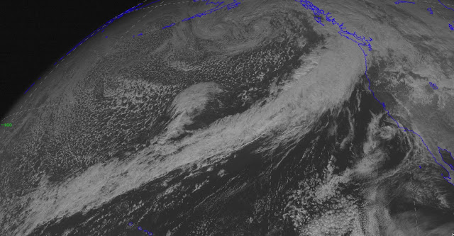
Finally, let me end with a most amazing satellite image (visible). You see the long cloud band stretching from the Northwest way back into the Pacific? That is the cloud signature of the atmospheric river....one of the LONGEST atmospheric rivers I have ever seen!


Yep. Sixty degrees feels great- but not good for the powder snow. I always say that skiing in the Cascades is a marginal thing- it just never stays cold, so the concrete factory keeps working.
ReplyDeleteIs this also what is called the "Pineapple express"?
ReplyDeleteIt's getting REALLY windy in Bellingham right now. Makes me wonder if they are underestimating the strength of the incoming storm...
ReplyDeleteEuropeanMan,
ReplyDeleteYes. Straight from Hawaii.
It gives us some of our highest dew-points, I believe.
That atmospheric river is nuts. The stream goes all the way to Midway Island and beyond!
ReplyDeleteWhat happened to the "drier northwest winter" we are supposed to have with this El Nino? It's been raining so much!
ReplyDeleteI remember roughly 2001 through 2005 always seemed to have one or two days late in January where the sun came out and it was nearly 70F. I suppose I need to go back through the temperature records to see if that actually happened, but maybe this will return us to that pattern and then we can have a decade of normal weather with... snow!
ReplyDeleteI remember your comments on the "United States Drought Monitor". How about a more reasoned voice? The USGS :
ReplyDeletehttp://waterwatch.usgs.gov/?m=dryw&w=map&r=us
And:
http://wa.water.usgs.gov/news/drought/wa.html
I think you did mention stream flow a while back, was this the source of that information?
I echo what Monica said. Record December rain - ok, so El Nino kicks in after Jan 1. Closing in on Feb and yup, again above - not below - average rainfall.
ReplyDeleteSo El Nino kicks in when again? May?
Looking forward to understanding why this winter has been so wet during an El Nino. I'm not a meteorologist by any means but I am a forecast analyst for a shoe company. I have to report on my forecast accuracy after every month. Do meteorologist do anything similar?
ReplyDeleteI too am very curious about this year's El Nino. All the forecasts predicted torrential rains for the LA area and a dry winter for us. Since October 1 SeaTac has received 30.99" and Los Angeles (USC) only 3.77". All the experts say is "wait for it, wait for it, wait for it..."
ReplyDeletePerhaps LA will get its El Nino rain in Feb/March, but what if it doesn't? I have seen no theories on why this could potentially happen. Is there a possibility that climate change is reshaping the effects of El Nino, and shifting the atmospheric rivers north?
Of course, when LA gets 15" of rain in February and March, you can delete this post!
SO many snarky comments about forecast accuracy and whatnot.
ReplyDeleteWeather is not a simple system. It is the interaction of multiple systems and events, any of which can have a cascading and greater impact on outcomes.
It is never absolute; never guaranteed. Forecasts are just that - guesses using the best information available overlapping historical observations.
And for the record, the trend for El Nino's, regardless of strength, is for warmer and drier temperatures. Bout that is just a trend. It is not an absolute as history shows. There have been other wet/cooler El Nino type events (below the mean/median/whatever).
Indeed, I'm not seeing any weather that's far wide of what I recall of the forecast discussions at the tail end of summer. At the time, the unknowns seemed to be centered around the El Nino being "super" and possibly bringing more precipitation. Anyone with a search engine can find the predictions:
ReplyDeletehttp://www.cpc.ncep.noaa.gov/products/archives/long_lead/gifs/2015/201509month.gif
http://www.cpc.ncep.noaa.gov/products/archives/long_lead/gifs/2015/201510month.gif
http://www.cpc.ncep.noaa.gov/products/archives/long_lead/gifs/2015/201511month.gif
Note the general increase in temperature outlook. The below normal precipitation outlook seems to have been something of a miss if one isolates to SeaTac, where December and January month-to-date precipitation was/has been above normal. Checking plots around the state seems to suggest that the dryness is a bit further southeast than anticipated. Of course, if the rain we normally get through May doesn't appear...
How about the El Nino discussions? http://www.cpc.ncep.noaa.gov/products/expert_assessment/ENSO_DD_archive.shtml
The September discussion was fairly non-specific about precipitation. October said "Outlooks generally favor below-average temperatures and above-median precipitation across the southern tier of the United States, and above-average temperatures and below-median precipitation over the northern tier of the United States". November said the same thing.
What did Cliff say? Again, the search engine reveals.
http://cliffmass.blogspot.com/2015/09/godzilla-el-nino-versus-blob-who-will.html says "A strong El Nino bring modestly warmer than normal temperatures, with a snowpack about 20% below normal. Much better than last winter. The correlation with Northwest precipitation is weak. Less lowland snow and fewer major storms. Enhanced precipitation over southern/central California."
http://cliffmass.blogspot.com/2015/09/the-battle-of-almanacs-what-will-our.html says "Precipitation? A bit drier than normal over us and wetter than normal over California".
What about California precipitation? http://www.wrcc.dri.edu/cgi-bin/anomimage.pl?cal30dPpct.gif Lots above, some below.
CA drought? http://droughtmonitor.unl.edu/data/jpg/current/current_ca_trd.jpg Note that the D4 is holding over last year, but other categories are in recovery. They may not hold if the rain doesn't.
NOAA CPC verifications? Yeap, got those too: http://www.cpc.ncep.noaa.gov/products/predictions/long_range/tools/briefing/seas_veri.grid.php
That's an awesome satellite image; the analysis is fascinating. As for the odd winter warm spell we have occasionally, I for one say, "Lucky we!" Anyone who's lived through a winter in the mid-states along the same parallel (International Falls MN or Green Bay WI) would agree. These events are grand.
ReplyDeleteBrian -
ReplyDeleteI would agree with you if in fact the forecasting was as benign as the links you sent. But it wasn't.
The majority of the forecasting was accompanied by threats of continued drought (NOAA: "Drought: Continue or Worsen"), a drought that on the west side of the Cascades was already dubious at the time, and made more so by the substantial fall precip here in November. It was accompanied by near hysterical proclamations by the Washington Dept. of Ecology, which Cliff called out not once, but twice before they stopped.
I long for the days when forecasting was exactly as you referenced. Simple percentage expectations done in an apolitical climate. Cliff by far comes the closest. But if NOAA feels the need to send out press releases and make fancy videos, if the DOE feels the need to be out there saying "Right now, nature seems upside down" - then they should expect the public to question the veracity of their proclamations when they fail, particularly when they fail to the degree they have on this.
As Cliff concluded in his 9/26 post (which contradicted both the NOAA forecast and the DOE): "The drought is not going to get worse and we should be in a much better place next spring than this year. And California will get substantial relief. I really worry that some of the media and in political circles are going too far in painting an end of the world picture for next year. Crying wolf undercuts credibility."
That pretty much sums it up for me.
hareschase,
ReplyDeleteMy feeling is that this el niño, la niña predictions are not as accurate as a lot of people would like them to be. I speculate it's an average with a big standard deviation. There are certain patterns that they bring but with large deviations. Look for example at temperatures. They are predicted again to be in the lower 30s for early next week and a chance of snow in North Bend.