Morning temperatures will warm, freezing fog will lessen super temperature inversions will fade, and the hated Southern California wildfire smoke will leave our region for good. But the ridge of high pressure is not done with us, continuing in a weakened form.
Today and Thursday should be dry, but by Friday, the probability of precipitation will increase---withe light rain Friday, Saturday, and into next week.
Let's look at the forecast upper level maps. One valid at 4 PM today shows a ridge (high pressure) over us...and you can see the weak upper level disturbance (trough) over Idaho that brought some clouds yesterday.

The map for Friday at 10 AM shows a modest upper level disturbance passing through, depressing the ridge. Clouds and perhaps some light showers.

But fast forward to Sunday afternoon at 1 PM. The ridge is still there, but pushed southwards, and we are in the northern portion of it, with strong flow going into northern BC.
Meteorologists call this a dirty ridge. No...nothing to do with porn, but a ridge that allows some clouds and perhaps some light rain. But no real weather.

The 72-h precipitation total ending 4 PM Friday shows unremarkable precipitation over Washington and Oregon. Even the north Cascades only gets a few tenths of an inch.

The next 72hr? Pretty much the same story.

Snow in the mountains? You don't want to know about it. Not much during the next week. Best bet is north, up at Mt. Baker and Whistler.
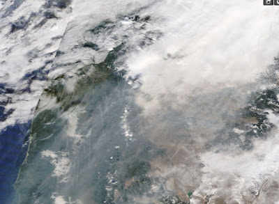
Finally, the smoke issue. Yesterday, a lot of California smoke reached the Northwest (see midday image from the NASA MODIS satellite below)

Here is a close up view centered on Oregon. Yuk. Look closely...do you see a lot of fine lines? Those are aircraft contrails. You can also see the darkening effect of the smoke over the low clouds of eastern Washington.
The forecast models are moving he smoke out and it should stay out for the rest of the season. A California import we don't need.


Looks like the change will be only temporary. The ridge will be back, even more amplified,after the 20th.No Christmastime snow for the skiers this year.
ReplyDelete2015/2016 they forecast a super El Niño and a horrible ski season for the PNW. We ended up being slightly above average and had an epic Dec. This year they forecast a great ski season and so far we look like we’re headed toward a repeat of 2014/2015. Doesn’t inspire any faith in seasonal outlooks.
ReplyDelete"After over a week without rain" I wish we could say that because parts of Santa Barbara where the Thomas Fire is are closing in 300 days without rain.
ReplyDeleteAbout time for snow pack update. Not looking quite so cheery is it?
ReplyDeleteLike John said, looks like this cycle is just a brief interruption to what looks like the RRR's permanent fixture this winter.
ReplyDeleteCliff I think we'd all enjoy reading your take on Swains view of the RRR. Maybe a future blog post down the line?
I also remember another scientist theorizing that the jet stream would become more wavy as the earth continues to warm, but you stated this as not being supported by the models. This RRR the past few winters seems to suggest otherwise. Ill try and find my original comment. But there are more sources suggesting this in, in fact impacted by global warming and expected to continue trending in the future. Here are some sources:
http://news.psu.edu/story/458049/2017/03/27/research/extreme-weather-events-linked-climate-change-impact-jet-stream
Does it ever end? What happened to La Nina? Seems it's a now show!!!
ReplyDeleteTowards the end of next week the Weatherbug forecast (for Eatonville) shows its going to get a bit chilly out. It's been showing a similar forecast for the last few days. I know it's a week away but what's your opinion? Does it look like we might have a cold spell coming and would there be a chance for any snow, be it lowland or mountain snow? It just seems like it's been a pretty boring fall so far (with the exception of the 60 mph winds that took a few shingles off our roof a few weeks ago). Hoping winter might be a bit more interesting.
ReplyDeleteWeather Underground, at this moment, is currently forecasting over 2 inches of rain for the Seattle area through 12/22 (on their 10-Day forecast). That is a significant departure from what you are saying here. It includes a forecast of .63" on Sunday; the Weather Channel is saying a quarter inch on Sunday.
ReplyDeleteUnderscores the variables in forecasting I guess but it will be interesting to see how this plays out.
Ive been paying attention to models and other forecast discussions.
DeleteSeems to be a lot of variation and lack of consistency in the models as of late.
Basically, this isnt at all surprising.
A teaser (but very low probability) of low-land snow next week with a Fraser River outflow. But at least they are talking about "maybe". Here's the quote from this morning's NOAA Forecaster Discussion:
ReplyDelete"Once the deepening low passes east of our longitude, a fairly cold
ocean-modified air mass will spread across the Pacific Northwest
next Wednesday, along with typical post-frontal showers. For being
a Day 7 forecast, there is strangely good agreement in models
depicting Fraser Outflow initiating late next Wednesday or on
Thursday, bringing even colder but drier continental air from the
interior of British Columbia. Only two of the 06z GFS`s 20
ensemble members shows over 1 inch of snow at SEA and BLI next
Wed. In other words, the odds of significant lowland snow appear
very low right now through the middle of next week. Haner "
Cliff, can you please tell us why the Puget Sound Clean Air Agency says that Seattle has cleaner air than Pierce and Snohomish counties, on average, which get more burn bans? They say Seattle gets more wind. But I can't think of a logical reason why this should be so. King County is sandwiched between Pierce and Snohomish, so logically, it ought to be the dirtiest.
ReplyDeleteThis coming summer is going to be brutal if this persists. Yes, everyone (non winter sports enthusiasts removed) loves warm and sun in winter but careful what you wish for. You might get it. The snow pack is how we get through the dry season. So hope this RRR takes a hike or its gonna be our area burning down.
ReplyDeleteThe models have been a freakshow lately - no consistency, either run to run or against other models.
ReplyDeleteThe latest forecast discussion has three systems coming through Sunday. None are big, but the Friday/Saturday event by itself might cover the two 72 hr forecasts above. A fourth system Tuesday is now being advertised as windy with the prospect of heavy rain in the mountains.
That's not to say the forecasts cited above are wrong - they just lack credibility for the time being.
"This coming summer is going to be brutal if this persists. Yes, everyone (non winter sports enthusiasts removed) loves warm and sun in winter but careful what you wish for. You might get it. The snow pack is how we get through the dry season. So hope this RRR takes a hike or its gonna be our area burning down."
ReplyDeleteSnowpack is not how we get through the dry season, and Cliff has pointed this out in previous posts. We get through the dry season with our reservoirs. Please, check out the Seattle (SPU) graphs. There is no snowpack feeding our water supply after July 1, in any year. Last year (2017) we had a greater than avg snowpack and none of it was feeding our water supply after June because it was gone.
Here is a great post from Cliff in 2015 about reservoir management after a significant snowpack shortfall: http://cliffmass.blogspot.com/2015/06/the-super-heroes-of-2015-northwest.html
Currently our reservoirs are substantially above average for this time of year. The majority of the state was above average for precip in November; Seattle was >130% - in a month that even in a normal year is one of the wettest. Btw: we are currently at 115% of precip for the 2018 water year; 125% for 2017 ytd.
How does the weather in December act as evidence for what will happen 7 months from now?
"So hope this RRR takes a hike or its gonna be our area burning down."
ReplyDeleteSo then we're all doomed. Good to know.
It doesn't.
ReplyDeleteNot even science can predict that and I am presenting zero science. No maths or charts etc.
All that can be done is reference the past and whatever data pertaining to conditions was available at the time in order to reveal trends. Still, this type of weather is not something anyone anywhere should wish to be a long term trend.
One ridge for a few weeks in a season is not going to be the end of the world. The air pollution being trapped by the companion inversion and the warmer air aloft melting the snow pack while offering the total lack of precipitation to replace it...again, not the end of the world on the short term. Still, if the ridge comes back from the dead all winter or proceeds to intermittently persist in a zombie like fashion for months on end then that is what is called a drought. Even in The Walking Dead characters get killed off fairly routinely but these ridges just keep on coming back.
Drought is not the only concern for the reservoirs. There is also a booming economy. All those tower cranes downtown as well as construction in the 'burbs translates into more demand on that precious water supply. Some times exponentially. More water demand for drinking, industry, watering lawns (which is ridiculous), washing all those cars and don't forget that more pavement leads to more wasteful run off as well as more sewage to treat. There are plenty of "Al Gore" type factors too, but I won't even go there. This is just a practical posting. No one is going to stop the Boom Town party on account of a triviality like water until there might not be any left. Here it might be better to lean on the pessimistic side of glass half empty.
Anyway, with the water supply no one should be tricked that past or present performance guarantees future results. We want those suckers to stay full as a buffer for growth.
Eventually, they won't make muster without some serious conservation efforts or just plain having to build more of them. Or, placing a moratorium on growth. Which won't happen outside of normal market forces. Typically though when the economy goes bust, there is no guarantee of money to undertake a large civic project like a reservoir or aqueduct system, even though that would be the best time to build. Planning and financing has to occur while the boom is still on, just due to the lag in seeing a large municipal project through to completion.
looks like that forecast was only slightly wrong (by several 100%)
ReplyDelete