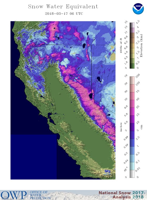
Here are snow water equivalent maps (amount of water in the snowpack) from the National Snow Analysis for February 17 and March 17. A huge increase in both depth and coverage.

The origin of the wet bounty over California was a shift in the large scale atmospheric circulation, with high pressure moving further offshore and persistent troughing (low pressure) developing over the West Coast. To illustrate, here is mean upper level (500 hPa, about 18,000 ft) heights for March 10-16th. The left shows the heights (analogous to pressure) and the right shows the deviation (or anomaly) from normal. A trough (low heights) is found right off the West Coast...that is culprit.

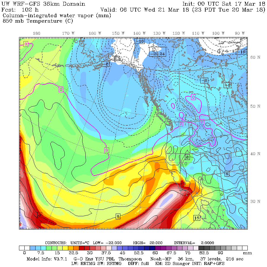
Well, this pattern is not going away...and in fact, it will amplify in a few days and our friends in California need to get prepared. A trough will form west of California with strong southwesterly flow on its south side, which will entrain large amounts of tropical moisture (see map for 11 PM Tuesday below)

How much precipitation will those folks in California enjoy? Here is the forecast accumulated precipitation over California for the next 7 days from the European Center Model: up to 6-8 inches in the Sierra Nevada and coastal mountains.

And plenty around southern CA, such as the mountains that surround LA.


With all the recent snow, the Sierra Nevada snowpack is about 60% of normal. It will get much closer to normal after the next few weeks. And the reservoirs, already around 100% of normal, will get topped off for the upcoming dry summer.
The only negative of all this precipitation is that it will encourage the growth of grasses, which can enhance the potential for fire danger next fall after it has dried out.


Looks like a continued LA Nina pattern into April.A cold trough passing through late next week followed by an extended period of a cool,NW flow.That should just about clinch an above normal winter season snowpack for the Cascades.
ReplyDeleteGreat news for CA.
ReplyDeleteI see we have finally lost all vestiges of the blob. Is the colder than average water off the Northwest a result of this trough or is it driving it?
This is as much a miracle as it is if it had snowed in January or February. Seriously Cliff, the people using the "march miracle" term are the same ones who called earlier weather the "RRR" and use the term "bomb cyclone" to talk about Nor-easters. What will it be next year? What cool-kid marketing terms will be hatched next year to scare people?
ReplyDeleteHow much of this snowfall will just end up going back down rivers to the ocean because the reservoirs are full? My bet is a lot. A whole lot. Let's just hope this year they don't break a dam because of it.
Marketing terms don't help science. They hurt it.
I wouldn't say the only negative is that grass will grow. There is a serious threat to life and property from debris flows coming off the burn scars of the Thomas Fire. This appears to be a bigger storm than the January 9th storm that killed 21 people.
ReplyDeleteAs always, great even-handed reporting Cliff. Between this and the arguing about the definition of the word "dramatic" you're really doing wonders for the reputation of scientific meteorologists.
The phenomenon of calling normal weather events by nicknames was pioneered by The Weather Channel, which used to be a serious weather news outlet many years ago. Since then, they've become a sensationalized "National Enquirer - Lite" after being bought by NBC/Comcast.
ReplyDeleteSo true Eric. I was done with TWC when they started naming winter storms. No one pays attention unless everything is sensationalized.
Delete