
It's here.....
Cold, dry modified arctic air is now pushing through the Fraser River Valley into Bellingham and areas to the north.
Here are the latest observations at the Bellingham Airport. Look at the wind direction. It shifted from southeasterly (90 is E, 180 is S, etc) to northerly and then northeasterly (20-30)---air coming right out of the Fraser! As the wind direction shifted the temperature began to drop rapidly (now 35F) and the dewpoint dropped to 31F (which means the air is getting drier). Lower humidities HELP snow, since it facilitates evaporation and thus cooling.
 Bottom line--it is probably now cold enough for snow in Bellingham...and that NE flow is going to strengthen and push over the San Juans and then to Vancouver Island and then head down to the Olympics. And these folks are probably going to see some light snow before this is all over. And yes, some strong winds for Bellingham and the San Juans. Believe me...it will get fiercely windy at the top of Mt. Constitution on Orcas before this over. And I expect Jim Forman and the rest of the TV folks to be stationed at Bellis Fair Mall in N. Bellinghan as they always do...with the flags waving in the background.
Below is the 24-h snowfall ending 4 PM on Saturday. Snow from north Bellingham across the north San Juans..and then southern Vancouver Is. And the northern part of the Olympic Peninsula just back from the water.
There is another focus of snow...SE of the Olympics around the Hood Canal...their snow will be from SE flow that will ascend those Olympics slopes. Heavy precip pushes the freezing level down...bringing snow with it. Otherwise...no snow on Saturday for the lowlands--but some light snow in the mountains.

There really is very limited moisture with this event...and that is working against any significant snow. Most of the area will get nothing.
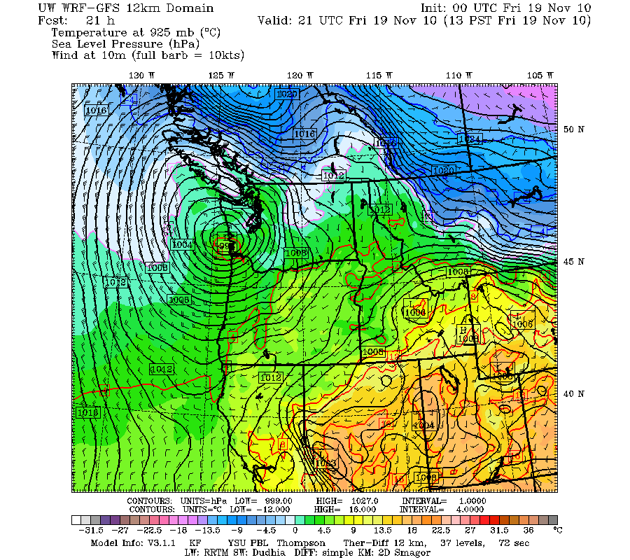
Finally, let me admit something...there are a lot of very nervous meteorologists in town. We look at the forecast pressures and temperatures for tomorrow at 1 PM (below) and see a low over SW WA and cold air over BC, ready to be sucked down towards the low. Cooler air is already moving into the Fraser Valley and out into Bellingham. This is close to a pattern that brings snow...but the models are emphatic that it is too warm over most of the lowlands for snow. The freezing level is at around 2000 ft and the snow level is around 1000 ft. This is close. If our models are wrong....well, you know what I am worried about. It won't be the first snow mistake we've made.
PS: Tuesday AM looks VERY COLD


Starting to "slush" here in Ferndale, Fraser winds are definitely picking up. Read your book last year- GREAT info. Thanks for all your hard work, it brings a whole new aspect to weather in the NW- BRAVO!
ReplyDeleteCliff...Telling us it's not going to snow and then it does anyway...that's the one forgivable forcasting mistake in my book! I love waking up in the morning to an unexpected snow when everything is bright white, sparkly, cold, and just beautiful! I love it! And it's so much fun to wake up the kids and to hear them squeal with excitement! So, if you're wrong....we forgive you!
ReplyDeleteOne other note, probably is nothing, but the free sample ECMWF, has a weak circulation around Mon-Tue. Should easily be cold enough everywhere, but like you said, you need that moisture too.
ReplyDeleteToo bad we don't have that coastal doppler radar yet or we could be certain exactly what would happen next... hahaha
ReplyDeleteAs far as upslope flow onto the north and east sides of the Olympics... how does the current scenario compare to Feb 25-26 2009? I vaguely recall that being a much more quickly moving low out of the WNW.
In other words, there *could* be some quasi serious lowland snow.(Anything over 1/2 inch being serious in the lowlands!) But its more a statement of a potential based on forecast uncertainty. But layperson weather geeks LOVE that! (however much it may drive the pros crazy.)
ReplyDeleteLiving in Portland, I know the dynamics of these events are both similiar and different, having to do with the Columbia Gorge, and in this case the position of the low and all that. Wish you could cover our area with more specificity (we *are* part of the NW afterall), but know you have to limit your normal scope.
"snow mistake". It must be wicked hard to forecast snow in the Puget sound, because by and large, the snowfall we hear about often doesn't come, and the big dumps also come with little or no warning. I've lived here for nearly 30 years, and although the big snows are few and far between, they often arrive as a surprise to everyone.
ReplyDeleteThere's already some frenetic snow-panic scurrying going on in SEA. Now there will be a stampede for de-icer, sleds, cocoa mix, firewood, and brandy!
ReplyDeleteCliff says "Believe me...it will get fiercely windy at the top of Mt. Constitution on Orcas before this over."
ReplyDeleteBut the NWS Point forecast set atop Mt. Constitution calls for a brief period of 30 mph winds with 41 gusts, from 10 pm to midnight Friday night, and then nothing above 26 mph until 4am on Wednesday, when they jump back up to 25 and diminish gradually through the day. Up here, 26 mph is just typical November wind, nothing at all to get excited about, let alone consider fierce.
So. Who will prove to be right? Cliff Mass or the NWS Forecast Office? I'm betting on Cliff, but we'llsee.
Hey Cliff, a bit off topic but did the WRF-GFS just get the ability to display wind gusts? I JUST noticed it was available on the atmos.washington.edu site and it's amazing! I never took the 10m Western Wa wind speeds in the model seriously because sustained wind over our topography isn't terribly relevant during big wind events in my opinion. Anyways, it shows some gusts to 65kts over the islands and then slamming into Vancouver Isl. Also shows 55kt gusts affecting Tatoosh and the north coast. Wish I had this to look at for the '06 storm.
ReplyDeleteFYI it's Bellis Fair Mall in Bellingham.
ReplyDeleteLet's start the chant now:
ReplyDeleteFORMAN! - FORMAN! - FORMAN!
In the 915 AM PST FRI NOV 19 2010 ADF there is a idea reminiscent of a comment made on the previous blog entry by Mattias ("What are your thoughts on possible convergence forming along the arctic boundary? ").
ReplyDeleteTHE FRASER OUTFLOW IS FCST TO PICK UP SIGNIFICANTLY BY EVENING AND IF ENUF MOISTURE PUSHES UP TOWARD WHATCOM AND SAN JUAN COUNTY WE COULD SEE SOME FRONTOGENESIS...I MAY HAVE TO PUT SOMETHING UP FOR THAT AREA FOR LATER TODAY. BUT FOR NOW IT IS WATCHING THE RADAR...THE 88D IS NOT YET SHOWING MORE THAN SCATTERED LIGHT SHOWERS BUT WE WILL SEE IF THIS PCPN BAND STARTS TO DEVELOP THIS AFTERNOON LIKE THE MODELS SHOW
So watch the radar later today and look at the obs temps to see if we do get a small front in Whatcom and Island Counties.
Kevin...this is not correct. The snow level and the freezing level are not the same. Typically, the snow level is about 300 meters (roughly 1000 ft) lower than the freezing level...cliff mass
ReplyDeleteI shouldn't even say this, but the 18UTC NAM has a blizzard across the whole PNW, especially pts. south and Mts. after this weekend.
ReplyDeleteSure it should be discounted for now, but you can't deny it doesn't spark future interest.
Cliff, I am grateful for the source that directed me to your blog. Always an interesting read, and checked at least once daily if not more. Thank you for sharing all your expertise with us!
ReplyDeleteI was right to trust Cliff when he talked about high winds over Mt. Constitution. This morning the NWS point forecast for Mt.C. showed nothing remarkable. But now suddenly they are showing wind gusts up in the 50s. Clearly Cliff saw something before the NWS did. But so far, no wind advisories for the San Juans.
ReplyDeleteOTOH, the NWS point forecast for my location shows, at 5:00 (15 minutes from now), sustained 36 and gusts to 54, but looking out the window it's dead calm.
Why do I even bother looking at anything other than this blog???
The NAM has been persistent with its developing of a low with the reinforcing cold shot of air Sun night into Monday.
ReplyDeleteIf the trajectory of cold air gets out over the ocean just a bit, watch out...
The NWS is saying there is a SLIGHT CHANCE of 4-8 inches south and east of Seattle Sunday night into Monday afternoon......Please, please, please let this be right!
ReplyDelete"PS: Tuesday AM looks VERY COLD "
ReplyDeleteIf mid 20s are "VERY COLD" (all in caps) I wonder what the forecasted lows in northern Montana of 20 below zero - in November - that same morning are called? haha
The 300 PM PST FRI NOV 19 AFD mentioned the NAM suggestion of a lot of snow on Monday but the other models aren't lining up behind it.
ReplyDeletehttp://www.wrh.noaa.gov/sew/gafd/latest_webafd.html
IF THE 18Z NAM HAS THE RIGHT IDEA THERE IS AN INCREASING CHANCE OF SNOW OVER WRN WA SUNDAY EVENING AND MONDAY COULD BE A SNOW DAY. THE 1000-850MB THICKNESS IS MORE THAN COLD ENUF AND THE 24HR PCPN ENDING 4PM MON RANGES FROM LIGHT AMOUNTS KPAE-KBLI AND THE NORTH COAST...TO A HEAVY SNOW FALL OF 4-8 INCHES SOUTH AND EAST OF SEATTLE. BUT THE ECMWF AND THE GFS JUST LOOK LIKE A REINFORCING SHOT OF COLD AIR...WITH PRECIP ONLY OVER OREGON. I CAN'T GO WITH MORE THAN 50/50 POPS FOR THE CHANCE OF SNOW SUN NITE THRU MON NITE BUT THE NAM SOLN BEARS WATCHING...SORT OF A NOV85 STYLE SYSTEM...THE EARLIEST I CAN SEE MYSELF PUTTING UP A WINTER STORM WATCH FOR THIS WOULD BE LATER SATURDAY...AND THAT IS ONLY IF THE NEXT TWO MODEL CYCLES LOOK LIKE THE 18Z NAM.
I'd wait for more NAM runs to confirm this before getting too excited (and mention it to my wife who's flying out of Seatac on Monday ...).
But if Jim Forman was every going to get into model prognostication now is the time. In his parka. In front of a computer. Explaining the model plots. Whilst being battered by a wind machine.