The regime in Libya?
No, we are talking about this year's La Nina and the cool, wet weather it has brought.
Astronomical spring might have arrived on March 21, but the past few weeks have been cool and wet, and nearly every day has been below normal. Here is the temperature difference from climatology (average conditions) for the past month: lots of below normal conditions (blue) in our part of the woods. In fact, this has been one of the worst early springs on record.
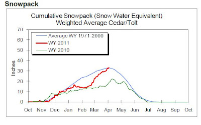
 A month and a half ago the snowpack was well below normal. Now the tide has reversed with above-normal snowpack over virtually the entire region (see graphic).
Here is an amazing plot from the Seattle Public Utilities web site showing the extraordinary jump in snow pack over the past month. You will be able to water your lawn this summer!

Over Texas and the southeast, La Nina has brought warm and dry condition--the result has been a series of destructive wildfires over Texas: here is some dramatic video footage:
But La Nina is dying. Look at the temperatures in the tropical Pacific:
 The colder than normal anomaly is weakening. And if you look below the surface, colder than normal water has been replace by warmer water...ready to push the surface! (see graphic)
 And the latest computer simulations indicate a transition to a neutral state (neither la nina nor el nino)....but keep in mind there is plenty of uncertainty (see graph)
But none of this will do us any good this spring and the National Weather Service is forecasting colder than normal temperatures over the next month:
 Don't blame me....


We don't blame you Dr. Mass. :)
ReplyDeleteBut a question for you, are colder and wetter Springs becoming more common? We're off to another cold, wet start this year. Last Spring and (most of) Summer was horrendous as many remember. Spring 2009 was warmer, leading into our scorcher of a summer. But I also recall Spring 2008 as cooler (it hit 80 in early April and then snowed).
Granted that's a small sample size, but it doesn't seem to matter if it's a neutral, El Nino, or La Nina year, Springs are trending cool and wet. Perhaps there's nothing statistically significant to this, or alternately something like PDO might be at work?
As a native northwesterner, the lackluster Springs are starting to be a big downer.
Thanks for the update, Cliff. Looks like the Northwest is in for some May Gray.
ReplyDeleteIf it's a neutral year, does that mean the tropics could be more active?
It's off the topic, but this notion of "ribbon lightning" was new to me. Any enlightenment available?
ReplyDeletehttp://www.guardian.co.uk/artanddesign/2011/apr/13/rare-lightning-caught-on-camera#zoomed-picture
Wow, Olympic snowpack 196%? Incredible! I guess I'll be attempting some hike and ski in June!
ReplyDeleteWonderful to have some actual news to give hope, rather than "crappy for the foreseeable future."
I blame you personally for making our skiing last into the summer!!
ReplyDeleteI'm curious how this change in La Nina will affect the Pacific Coastal weather patterns in the late summer and fall (Aug - Nov). This is the traditional time for sailors to head South from Puget Sound. Are there any generalities or overall trend you feel we can forecast now?
ReplyDeleteThanks!
-p
And not just colder, but wetter. Ugly ugly stuff.
ReplyDeleteAnd there is this note from the NWS 9:30 a.m. PDT Discussion for our region
Climate note...there has never been an April in Seattle with zero
days of highs in the 60s including the federal building records
which go back to 1891. The record for the least amount of days with
highs 60 or greater for the month of April is 2 days set in 1954 and
1970. Felton
Actually, I think it has reached at least 60 two or three times this month where I live in Mountlake Terrace, but that doesn't change the fact that the weather this spring has been quite unpleasant in our region.
Matt is right on. On April 12, 2008 I went kayaking in my swimsuit on a lake in SW Washington. The next weekend I was trying to protect my garden from the snow.
ReplyDeleteI'd be interested in knowing what set of ocean conditions give us above normal springs. Seems like not El Nino, as we had one last year, yet the spring was still cool.
I'm glad I'm not imagining it, because I begin to worry that I'm just getting less and less tolerant of this climate. Die La Nina! Die! There shall be no 30 mph winds when the bumblebees are pollinating the apple tree this year. Please.
ReplyDeleteWell.. It is currently snowing in Bellingham!
ReplyDeleteThose poor flowers!!
Okay, I won't blame you, Cliff, but...who CAN I blame? I need to release my frustration on someone before I completely go insane. April 14 and pouring SNOW at my house (in north Whatcom County)???!!!
ReplyDeleteI'm a native Western Washingtonian but this weather is seriously getting to me. I'm firmly convinced cooler, wetter springs are becoming more common ~ at least over the course of the past 10 years or so.
Ugh. Double ugh.
Well, you can always move up into the Olympic rain shadow. As much as its rained up here in the Sequim area, its a small fraction of the Hood Canal or Seattle area.
ReplyDeleteMy closest weather station shows just over 8" of rain since the first of the year. That's a lot more than normal for 3 1/2 months, given we usually get 16 to 18" all year, but I suspect its a drop in the bucket compared to most other places in Western Washington.
When I occasionally drive down near the Hood Canal or even into Seattle, I'm amazed by how drenched everything is. I can't imagine enduring the near constant rains down that way, so my sympathies. If I was there, I'd also be looking to pull the rip cord and bail out by now. I know I'm a bit jaded, but its bad enough even in the rain shadow to complain about.
Of course, you are slightly warmer down there, which probably helps a little. We had snow on the 2000' high hill behind my house last night.
John Marshall
I don't know about the pundits, but the ENSO multivariate index still shows a pretty strong La Nina in progress:
ReplyDeletehttp://www.esrl.noaa.gov/psd/people/klaus.wolter/MEI/
Amazing amount of snow above 500ft in the islands yesterday morning. Orcas Island was plastered with snow. It looked like mid-winter. This morning there is still snow visible on the higher parts of the island.
ReplyDeleteI'm in complete agreement with Matt and Colleen: PNW Springs are trending wetter and cooler and it's getting to be a big, big downer.
ReplyDeleteBeing a native of Western Washington, I understand (in its most basic form) the convergence zone dynamic and the resulting amount of precip, gray days, etc. BUT...lately this stuff is getting ridiculous!! I'm not sure how many more gray springs I can stand before I pack up the family and head to warmer climes. :)