Parts of the central Cascades, including the Stampede Pass ski area, are getting BURIED with snow--roughly 2 feet during the last day--while Cascade snow to the north and south is modest--mere inches. Take a look at the latest cams for Route 2 and the base area of Stevens. Wonderful powder snow of a quantity and quality to evoke the jealousy of skiers in Utah and Colorado. Snowbird Ski area in Utah has only ONE-THIRD of the snow depth as Stevens.
Lets examine plots of snow depth at Stevens, Snoqualmie, Crystal, and Baker (ignore the spikes on Baker, these are data glitches) for November 29th (last Saturday) through today.
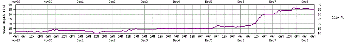
A big week for snow lovers, with huge gains at all locations. But look closely at the last day: there has been a huge increase at Stevens, from roughly
63 to 90 inches! That increase is due to the localized enhancement of mountain-forced convergence zones, or more correctly perhaps, the Olympic Mountains/Vancouver island convergence zones.
 |
| Stevens |
 |
| Snoqualmie Pass |
 |
| Crystal |
 |
| Baker |
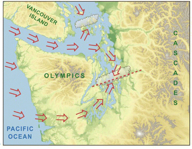
Many of you know about the Puget Sound convergence zone. Westerly or northwesterly winds move around the Olympics and converge on the eastern side, producing enhanced cloudiness and precipitation over Puget Sound, generally between Seattle and Everett. I spend quite a bit of time in my
book on this: here is one of figures from the book illustrating it.
But what is not as generally known is the effects of the convergence zone can extend into the Cascades, greatly enhancing precipitation (and in this case snowfall) for a limited area in the mountains. Also, the nature of the convergence zone can change, depending on the nature of the flow approaching the Olympics. With strong, less stable flow the convergence zone often extends more northwest-southeast, with the largest impacts over the eastern suburbs and the Cascades. We can also get a convergence zone downstream of the mountains of Vancouver Island or a mixture of the two convergence zones. I have spent a lot of time understanding the Puget Sound convergence zone, but need to examine the Vancouver Island one more, as well as their interactions.
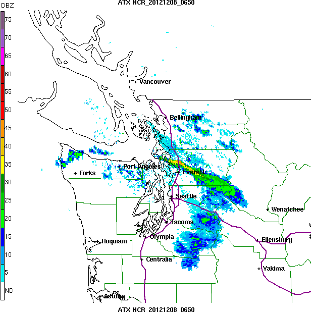
Lets look at some recent radar images from the Camano Island radar to see these convergence zones in action!
10:50 PM Friday night: Nice enhanced band--looks like it is downstream of Vancouver Island.
Two hours later, same thing.
This morning at 8:55 AM, the band is still there, but shifted south and a slightly different orientation.
To bring it all together, here is the 24-h precipitation total from Seattle RainWatch: you can see the net enhancement clearly.
Can our high resolution models simulate this interesting feature? Let's check out the forecasts from the super high resolution (4/3 km) runs done by my group at the UW and supported by the NW Modeling Consortium.
First, the precipitation forecast for the three hours ending 1 AM Saturday. It has the band...looks good.
Here is the forecast for the three hours ending 10 AM this morning: it suggests the development of a more southern orientation and a second band to the north (lets see if that verifies)
And finally the total snow forecast for the 24 hr ending 4 PM on Saturday: not bad..it shows the localized enhancement that is giving smiles to skiers at Stevens Pass. It also shows no snow over Seattle, in contrast to some scary forecasts heard on some media outlets I will not mention.

PS: I got some of the data above from the
Northwest Weather and Avalanche Center, a group deserving of your support. They include highly trained mountain weather and avalanche specialists and their web site is a treasure trove of mountain weather data.


Cliff, as a resident of the Skykomish basin, I wonder if you are familiar with any models being used to predict conditions if the basin transitions from snow-dominant to a rain-snow mix over the course of the coming century. Do you have an opinion on their strengths and weaknesses?
ReplyDeleteThank-you,
Gladys Gravyboots
Glad you put out the post cliff. Weather channel couldn't find a name for this and just did east coast wx.
ReplyDeleteThis is awesome Nw weather nowhere else can have a pass with 39" new overnight and nothing 10 miles away.
ReplyDeleteI left Sinclair Island on Friday. While having lunch on Guemes Island a squall came through. The wind shifted from SW to NW. Classic Vancouver Island convergence weather. Often such convergence will result in dramatic cumulus clouds and showers over Mt. Constitution on Orcas Island, undoubtedly contributing to increased precipitation there.
ReplyDelete