We have had one of the most spectacular falls in a long time, with temperatures well above normal for the last few days (see data from Sea-Tac Airport below.


Looking southward, the Willamette Valley was in the mid-80s. Folks, we are having early August weather in October.

But unfortunately, the models have become more persistent in predicting a major transition over the weekend to cooler, wetter weather--and this time with some staying power.
Let's compare the predicted upper levels maps (300 hPa, around 30,000 ft) for today at 5 PM with that of Sunday at 5 AM (see below). These maps show heights (like pressure) and the wind speeds (colored) Can you see the huge difference? In today's map there is a large ridge over the West Coast with weak winds over us.


Guess who the jet stream is aimed at DIRECTLY? You guessed it, Us.
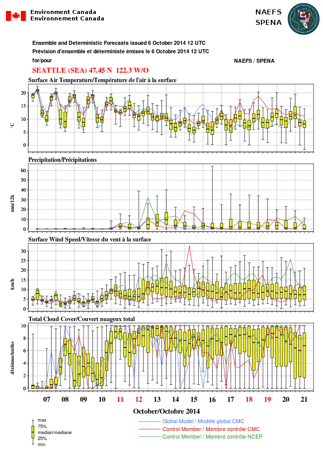
Now this is just one model. To forecast in a state-of-the-art way you need to look at ensembles...a collection of many forecasts...to get an idea of uncertainty. Here is one rendition of such guidance from the North American Ensemble Forecasting System (NAEFS) for one location (Seattle). Everything is in metric units (sorry). The yellow box shows you the range of the 50% of the ensembles closest to the median, the range of all ensembles by the "whiskers." The median is indicated by the horizontal line.
On Saturday, the temperatures begin to fall and stay down. Rain starts and stays. Wind speed picks up. And clouds move in and don't move out. Beautiful Seattle fall weather.
At least my grass will finally turn green. Enjoy.


What is the outlook for ski season this winter?
ReplyDeleteI have been watching this come on as well... Nice, just in time for the Seahawk game! But at least my seats are undercover. ;) GO HAWKS! Noticed Alaska is starting to cool down as well with snow fall increasing there. Fall is coming so enjoying the last bits of dry the next couple days!
ReplyDeleteone of the most spectacular falls? it's only been two weeks (and, yes, it's been awesome). too early to call in my opinion.
ReplyDeleteFall thus far has been typical here in north Whatcom County ~ certainly nothing spectacular or out of the ordinary. Pretty heavy fog lately, lasting through early afternoon. Some nice sunshine at times, but also a fair share of bland. Anyway I'm ready for true fall weather. Felt way too odd in early September to be warm while watching bigh school football. ;-)
ReplyDelete