Time to replenish our renowned water resources! And a good reason to be glad you don't live in California. And speaking of parched California, they are going to get a piece of the action.
Let's start by looking at the latest view from space, showing the amount of moisture in the atmosphere. Reds and purples are large amounts, and not surprisingly such enhanced values tend to be in the tropics. But a huge northward push of moisture is occurring in the central Pacific and a tendril of it is moving westward towards us. It has our name on it.

Let me show you the forecast atmospheric moisture for 2 AM on Wednesday morning. You can see the heavier moisture (blue and white) heading towards us. And when that moisture is forced to rise by our regional terrain, there will be lots of precipitation.

How much? Here is the forecast from the UW WRF model for the 72 hours ending 5 AM on Thursday. Big values (more than 5 inches in the Olympics, North Cascades, and northern Oregon coastal mountains. An inch or two in the lowlands. Rake the leaves from the drains near your house or apartment!
.gif)
The next 72 hours? Still wet, but less so. 1-5 inches over the region west of the Cascade crest. One good thing: northern California will get enough rain to begin to fill their thirsty reservoirs.
.gif)
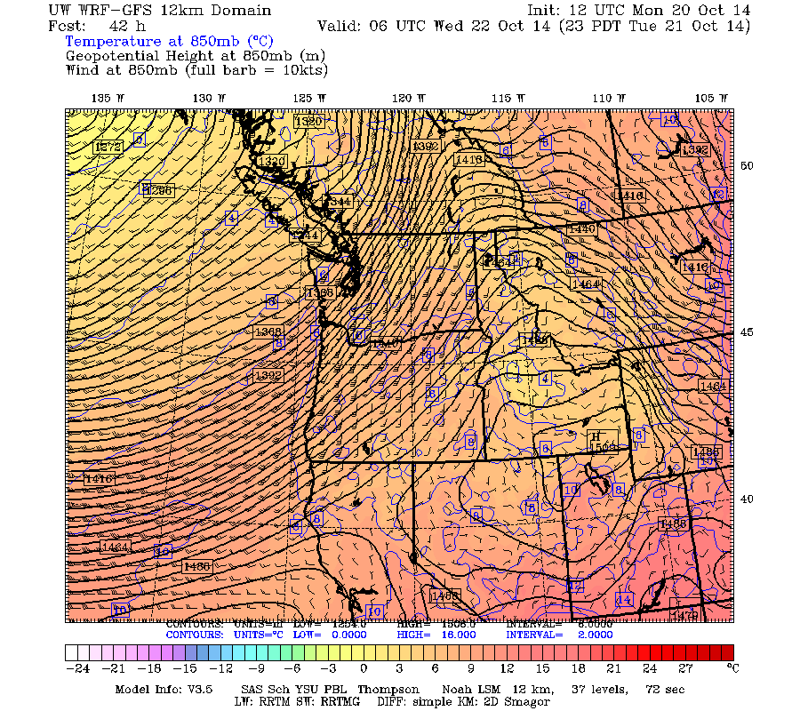
As with most atmospheric rivers, there will warm temperatures and strong, but not damaging, winds (30-40 mph on Tuesday night and Wednesday AM). To illustrate here are the forecast temperatures, heights and winds near crest level (850 hPa, about 5500 ft) on Tuesday at 11 PM. You see how packed those height lines are approaching the Oregon/WA coast....those are associated with strong SW flow. Reds are warm air.
Let me make clear...this is NOT going to be a record event. But it will be the wettest period since last winter.
Finally, a number of the modeling systems are predicting that a deep low pressure center will approach our coast on Saturday morning. Here is the solution from the U.S. GFS model (the solid lines are isobars, lines of constant pressure) for 8 AM Saturday. Huge pressure difference (gradient) along the southern Oregon coast...with big winds (50-75 mph). The European Center model has the same low, but fuarther north and offshore. It will take a few days for the solutions to stabilize...but this is worth watching.

The latest run is in...and it is getting more threatening for western Washington! This is valid 5 AM Saturday. Only a 108 hr forecast...close enough that you got to be concerned. 985 hPa low. This would be a major windstorm folks.

Here is pressure and sustained winds (kts) for the same time. Wow...serious winds along the coast.


And purely for entertainment purpose, let's watch what happens to the remnants of tropical storm Ana....!
ReplyDeleteHey Cliff, between your previous blog about the Minimum Temperature heatwave and this post about the coming heavy rain, here are 2 questions: (1) have the dewpoints in western Washington also been setting records for persistence, i.e., amount of time dewpoints remained over 55, and (2) do you see any similarities between our current situation and the fall period that led into the terrible Nov 2006 - Jan 2007 rain/wind/snow episodes?
ReplyDeleteSurprisingly, none of the local stations have mentioned this yet. Please keep us posted, Cliff!
ReplyDeleteFrom this morning's SEA NWS forecast discussion. Echoes of the '62 Columbus Day Storm:
ReplyDeleteFARTHER OUT...ALL OF THE LARGE SCALE MODELS...AS WELL AS THE LATEST
12Z NAM12...ARE SHOWING GOOD SURFACE DEVELOPMENT OVER THE EASTERN
PACIFIC THU NIGHT INTO FRI AS ENERGY DUMPING SOUTHWARD FROM THE
BERING SEA INTO THE NORTH PACIFIC PHASES WITH THE REMAINS OF
HURRICANE ANA THAT HAS RECENTLY IMPACTED WESTERN HAWAII. THIS LOW
DEVELOPS OFFSHORE THEN POSSIBLY DECAYS SOMEWHAT AS IT MOVES INLAND
OVER THE FIRST PART OF NEXT WEEKEND. THIS SYSTEM WILL NEED TO BE
CAREFULLY MONITORED. ALBRECHT
Don, yeah, recalling that Frieda helped give the Columbus Day Storm an extra jolt, that's what I thought too. Still way too early. The difference of 100 or even 10 miles in the storm's center can make a huge difference. Still, definitely interesting and definitely bears watching...
ReplyDeleteWell, it IS October and we often get a big wind of varying strengths this month.
ReplyDeleteSo this is our second 'atmospheric river' event and we are only in October...Does this mean more to come during the weak el nino fall/winter ahead?
ReplyDeleteMark H
So we're not going to have a good time at the Sounders game in Seattle at noon on Saturday, are we? *sigh* My 6-year old will be crushed.
ReplyDeleteCliff,
ReplyDeleteThis rain may seriously impede viewing of the the partial Solar eclipse on Oct 23.
You helped save me in 2012 during the transit of Venus when you said within two hours of the start of that event that travel from cloudy Seattle to partially sunny Aberdeen had the best prospects. You were right, I went and saw it for myself!
So what about Thursday's partial eclipse? Any prospects of seeing the sun anywhere within 3 hours drive (or more)? It starts at 1.35pm, peaks at 3pm and ends at 4.20. Thanks!
"'We know it is going to be a rainy pattern but it's difficult to know how much precipitation we'll get,' Environment Canada meteorologist Andrew Besson said Wednesday."
ReplyDeleteLooks like southern BC got walloped, and their forecasters don't have as much data as we do!
http://www.vancouversun.com/technology/More+storms+Metro+Vancouver/10310652/story.html