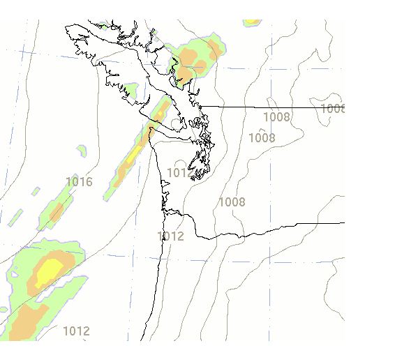
The weather predictions for Friday afternoon was for relatively warm conditions (70F for Seattle, 72 Tacoma) with only a slight chance of rain (roughly 10%).


Or the UW WRF for the same period:

It became evident in the morning hours that the models were missing a major ingredient as precpitation was evident offshore and then moved in over us--thanks to the new Langley Hill radar (images at 10:30 AM and 12:03PM):


Here is a nice video showing the development of the mid-level convection:
http://www.atmos.washington.edu/~ovens/loops/flash2.cgi?/images/webcam2/movies/20110930.swf
So if one watched the radar carefully, you could have seen the forecast going wrongand alter it....we call this nowcasting.
So what went wrong? There appear that there was a weak offshore disturbance that was poorly described in the initial state of our numerical models. Here is the 9:30 AM infrared satellite photo that suggests such a feature:

During the next few months the NWS and the UW will be using the information from the Langley Hill radar to initialize our models, perhaps this will help improve the short-term forecasts of such events, but it will do little to help predictions more that 6 hours out. To improve these will require better use of satellite data and more satellite data.
Note: The Camano Island radar is down now for upgrading to dual-polarizaton...should be up by the end of the week....cliff
DOG Alert
We had a solid spotter report of my lost cockapoo in Mountlake Terrace near Terrace Creek Park...if any of you live or work up there can you keep an eye out? For a picture of her, check the link on the right. Thank you so much.
http://misscockapoo.blogspot.com/2011/09/missing-black-female-cockapoo.html
Here is the area she was seen last in:

This dog was lost on 9/10 and has moved 10 miles in 19 days.


Okay, Cliff. I guess I have to go back to looking out the window and tapping the barometer. For 6 hours out I don't seem to do any worse than NOAA and the most powerful computers in the world.
ReplyDeleteCool Cliff, I know you were busy yesterday but I was wondering if you were going to say anything about it.
ReplyDeleteSeems like mid level convection really only wets the road briefly, but it really messes up max. and min. temperatures.
Models have just been poor lately. Just weird. Missed yesterday, over predicted today. Not even close precip. wise 24hrs ago. Not coming to a conclusion next week etc. All over the place.
If you see the intialization of the models are off, how can you even trust anything 6, 12, or 24 more hrs away?
Hey Cliff, any word on what's up w/ the Camano radar? It seems to have been down for days. On the NWS site, instead of seeing coverage we're instead invited to check the "Radar Status Message." The suggested link leads to "WSR-88D Radar Outage Notification... None issued by this office recently."
ReplyDeleteCould it be that weather radar is conservative in the NW, that when a new site comes up the old one stops working? Or, maybe it's more like utility AC power; should we call NWS to say we're in the dark? ;-)
I was fooled by the forecast also, i needed to release a new queen in my beehive on Friday. I felt pretty confident that i could wait until late afternoon to do that. i spent the morning in the woods but when I reached the shoreline of Dabob Bay and looked to the SSW the dark clouds and cool breeze told me that If I wanted to release the new queen i needed to run back to the cabin before the rain hit. I made it back in time to open up the hive to release her highness before it started to rain to hard. just a reminder to pay more attention to what the weather signs are telling us instead of relying to much on data.
ReplyDeleteHow much do you think Langley Hill is going to require a relearning curve. Will this tool actually rewrite some of the details of how our weather happens?
ReplyDeleteThe Camano Island radar down for upgrading to dual-polarization...should be back up in a few days...cliff
ReplyDeleteOn Saturday, I went to Blake Island with some of out of town friends. We were a bit afraid we would get rained on given the forecast, but the day was actually quite nice. Well probably only a native NW person would consider cloudy and cool nice. There quite a few sun breaks. It looked like we were in a bit of a rain shadow.
ReplyDeleteThere were some hints in the NWS forecast discussion issued around 9AM that morning,
ReplyDelete"SHORT TERM...BANDS OF HIGH CLOUDS ARE OVER THE INTERIOR WHILE THE COAST IS FULLY ENGULFED IN SEVERAL LAYERS OF CLOUDS.
BOTH THE GFS AND NAM CONTINUE TO INSIST THE ONLY RAIN THAT MIGHT FALL WILL BE ON THE COAST AND IN THE OLYMPICS AS A WEAK FRONT OFFSHORE DISINTEGRATES OVER WESTERN WASHINGTON. THIS IDEA IS IN THE FORECAST AND NO CHANGES ARE PLANNED."
In other words... I went with the models but my gut tells me something else.(bold & italics mine)
I checked the discussion during late morning when it got very dark over northern Kitsap County. What made it memorable enough to save was the stark contrast with the "Short Term Forecast" issued a short time later (1220 PM PDT)
".NOW...BANDS OF LIGHT SHOWERS OUT AHEAD OF A WEAK FRONTAL SYSTEM ARE TRAVELING FROM SOUTHWEST TO NORTHEAST ACROSS WESTERN WASHINGTON. BESIDES THE SHOWER ACTIVITY... THESE SYSTEMS MAY PRODUCE A FEW LIGHTINING STRIKES THROUGH THIS AFTERNOON."