June 30, 2025

Warming and Then Much Cooler for July 4

Time for the July 4th forecast, and we are close enough that skill should be good.  

The bottom line:  current warming (caused by high pressure aloft) will be followed by a cool-down as an upper-level trough approaches.

This morning, the Northwest was clear except for the typical June low clouds along the coast:


During the next 48 hours, a transient upper-level ridge will be positioned over southwest Canada, allowing temperatures to rise into the 80s in western Washington and mid to upper 90s over eastern Washington (see upper level map, 500 hPa, around 18,000 ft today).


The high temperatures as of 4 PM today (Monday) are shown below.  50s and 60s on the coast, 80s over the Puget Sound lowland, and 90s in the Willamette Valley. Toasty east of the Cascades.


Tomorrow will be similar.   But then the situation will change significantly as a complex collection of low-pressure troughs approaches the region (see the upper level map at 11 PM Thursday) as the ridge of high pressure moves eastward.


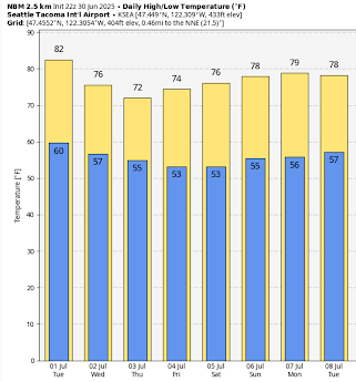
Consider the forecast temperatures for Seattle (below).   Lower 80s on Tuesday, followed by a decline into the mid to lower 70s.


In the Tri-Cities, temperatures near 100F will decline into the "cool" upper 80s.


The normal high for Seattle right now is about 74F and for the Tri-Cities about 88F.   So a return to near normal conditions by the end of the week...nearly perfect weather.

What about precipitation?

The predicted ten-day total is shown below.  Precipitation over northern BC, Idaho, and Montanta.  Eastern Oregon gets a few showers.  But nothing really over Washington.


Strangly enough, this has a silver lining:  no forecasts of thunderstorms over WA state, which means fewer fire starts.

Which is a reminder to be careful with fireworks...or avoid them completely.


June 28, 2025

Will Fewer Balloon Weather Observations Mean Reduced Forecast Skill?

 Due to retirements and hiring suspensions, the number of launches of balloon-launched weather balloons (called radiosondes) has been reduced by about 10% in the U.S.  

Specifically, of the 92 U.S. radiosonde locations, about ten have reduced launches either totally or partially.


Several media sources have suggested this reduction could seriously degrade U.S. weather prediction (see samples below).   


But is this true?   As discussed below, there are several reasons to expect that the impacts will be very small, not the least because balloon-launched weather observations now play a much, much smaller role in the modern observing network.

Why upper air data matters

The atmosphere is fully three-dimensional, and predicting the weather requires understanding the 3D distribution of temperature, wind, and humidity.

Such three-dimensional data is the starting point of the key technology of weather forecasting: numerical weather prediction (NWP), in which meteorologists simulate the evolution of the atmosphere by solving the equations describing atmospheric physics on the largest computers available.

Such forecasts start with a three-dimensional description of the atmosphere, called the initialization.

During the early years of NWP (1950-1970), radiosondes were the only source of weather information above the surface.  Absolutely critical.

The number of radiosondes has declined modestly over the years, with the current global network shown below.  

Lots over the U.S., Europe, and Southeast Asia.  You will notice a major issue with the radiosonde distribution:  there are few over the oceans and the polar regions, which encompass about 70% of the planet!


The current U.S. radiosonde network is displayed below, with red circles indicating radiosonde sites that are either suspended or only launched once per day.  Keep in mind that at most sites, these observations are only made twice per day.

Is there any objective evidence that forecasts have declined with fewer U.S. radiosonde observations?

As far as I can tell, the answer is no.  

I have gone through all the objective verification scores and could not find any degradation in National Weather Service forecast skill.  For example, the 5-day precipitation scores over the U.S. in March 2025 are better than March 2024.


I could show you a dozen more like this.  

But we have to be careful here.  Perhaps 2025 was an easier year to forecast.  

To do this right, we need to do OSSEs...observing system simulation experiments... in which we run identical periods we different amounts of radiosonde data.

However, there are powerful arguments about why the radiosondes are no longer as important to weather prediction, and particularly whether the temporary loss of a few of them would make much of a difference.

Today, three-dimensional satellite observations are dominant--in fact, approximately 99% of the weather data used today in numerical weather prediction is from satellites.    For example, we can determine the winds by tracking features in the infrared part of the spectrum.


 Or we can use satellites to measure how humidity varies with height.


Other satellites measure temperature and humidity with height by noting how GPS signals are bent by the Earth's atmosphere.


I have hardly warmed up.  There are dozens of other examples of how satellites provide detailed, three-dimensional weather data over the entire planet...over most of which there are no radiosondes.

But there is more.   Many aircraft take continuous observations in flight and provide vertical profiles of the atmosphere (called soundings) are they take off and land at airports (see below).   Such soundings are very much like the radiosonde data, but are taken at more locations and at more times.


The bottom line of all this is that balloon-launched weather instruments (radiosondes) are now only a very, very small proportion of the atmospheric weather data used by meteorologists for weather prediction.   

As a result, a loss of a few observations over a portion of one country probably has very little impact.

Thus, the headlines of gloom and doom are probably wrong.    

Let me be clear....I think we should restore the U.S. radiosonde network and then complete careful experiments to determine how many of them are really needed for calibrating the satellite data and other uses.  From what I have learned, restoration of the missing radiosondes will occur over the next few months, with the National Weather Service now hiring again.



June 25, 2025

Below-Normal Wildfire Year so Far

Announcement:

 I will be teaching ATMS 101 this autumn at the UW, so if anyone is interested in securing a basic understanding of weather and climate (UW students, non-students), you can check it out here.

________________________________________

Even with a relatively dry spring,  cumulative wildfire acreage in Washington State is currently below normal.  

You read that right, below normal.

Interestingly, the dry condition may have even contributed to the modest wildfire totals so far this year.

To start, consider the Washington State Department of Natural Resources (DNR) acres burned statistics for Washington State (below).  This year is very low...the second lowest since 2015.


Currently, there are only two significant wildfires burning in Washington right now, and both are relatively small:  the Pomas and Barstow Road fires (see map below).


While the wildfire season has been restrained so far, spring precipitation has been below normal, and temperatures have been above normal (see plots below).  

Western Washington has been particularly dry, with the Columbia basin modestly below normal.


So, how could the wildfire area be less with warmer and drier conditions?

Because wildfire generation is more complicated than communicated in the media, such as the Seattle Times.


To get a wildfire, you need ignition, sufficient fuels, dry fuels, and supportive meteorological conditions, with wind being the most important.

Precipitation during late winter and spring is important for producing bountiful light fuels, such as grasses and range-type vegetation.

Rainfall deficit has resulted in normal to lower than normal amounts of annual vegetation over much of the region, something shown by the USDA Fuelcast site (see graphic below).


Last weekend, I explored the situation in the hills north of Teanaway, WA on the eastern side of the Cascades.  Grass productivity was less than I have seen in recent years, and much of it was still green in forested areas (see pictures below).


So we start with a light to normal fuel load over much of the region.

What about ignitions?  

 Many utility companies are stating they will be more aggressive with strategic power shut-offs, which should help.   But what about lightning-initiated fires, which are often in remote areas and difficult to extinguish?

The extended precipitation forecast this summer is for drier than normal conditions (see below).  Since thunderstorms are the big precipitation producers for much of the summer (particularly east of the Cascade crest), this implies fewer thunderstorms.


Which means fewer lightning starts and fewer ignitions.  This implies less wildfire activity.

August and September are generally our big wildfire months.   The European Center's prediction of precipitation anomaly (difference from normal) is near normal for August (except north of the border) and perhaps wetter than normal over western Washington in September (see below).   Not very threatening.


All in all, I don't think there is much reason to expect an above-normal wildfire season over Washington, even with the teeth gnashing in a certain local paper.

David Horsey, Seattle Times


June 23, 2025

Alaska Wildfire Smoke Reaches the Pacific Northwest

The visible satellite imagery this morning clearly showed a plume of smoke aloft extending southward over eastern Washington:


This smoke originated from some large fires over Alaska and northern Canada, as shown by the AirNow graphic:


Most of this smoke remained aloft, but some surfaced east of the Cascade crest, resulting in moderate air quality (yellow dots).

Why did the smoke push down in the Northwest?  

Because a ridge of high pressure developed over the eastern Pacific and winds are northwesterly on the eastern side of such features (see upper level (500 hPa pressure, about 18,000 ft) map at 5 PM Sunday).


Fortunately, the pattern is already changing, with the air flow turning more westerly, pushing the smoke to the east.  Expect better air quality aloft this week, including a turn to cooler, wetter weather.

Finally, I should note that there is relatively little smoke contribution from local wildfires in Washington State.  Today, there are only three modest fires in or near Washington State (see map).

The slowly growing 1000-acre Pomas fire near Lake Chelan, the 2000-acre Barstow Road fire burning in grass and farmland, and the 3700-acre Rowena fire burning in grass and logging debris.  The Rowena fire is nearly completely contained. 


As I will describe in a future blog, it has been a below-normal wildfire year so far in Washington State.


June 21, 2025

Summer Snow

It is now officially summer.

It is now snowing in the mountains above approximately 5000 ft.

Here are some recent cam shots at and near Paradise on Mount Rainier.  Paradise is around 5400 ft above sea level.


The latest model forecast predicts up to a half-foot of snow above 6000 ft.


At Stampede Pass at 4000 ft in the central WA Cascades it is raining and 38F.

Perhaps not the best day for a hike.  Tomorrow will be far better.


June 20, 2025

Major Errors in Seattle Times ClimateLab Article on Sea-level Rise

My frustration with the often false, misleading, and exaggerated information pushed by the Seattle Times ClimateLab is frequently expressed in this blog, but the tall tales provided this week is worth a rating of at least four Pinocchios.  

The story suggests that the Samish Tribe of NW Washington has to "race" to document their heritage sites because rising sea level and "intensifying storm surges" remove any chance to  understand their significance."   

In reality, none of this is true.

Using the map in the article, here is the region of Samish tribal lands (see below).  


The Seattle Times claims that 

Already, ocean waters around Puget Sound have risen some 9 inches since 1899 and climatologists expect the waters to rise perhaps a foot or more by 2050. This will cause coastal flooding and erosion, both of which will also be made worse by intensifying storms throughout the region.

This is totally wrong and contradicts observations and the best science.

First, there is no evidence...none...that storms are intensifying in the region.  All studies, including one done by the UW Climate Impacts Group, contradict this.  I have done research on this subject as well, including a careful study of climate model projections.   

NO INCREASE IN STORMS.  The Seattle Times' claim is in error.

Second, the Seattle Times used the wrong sea level rise information.  

Sea level rise is NOT uniform over western Washington and is much less in the northern waters where the Samish tribe is located.

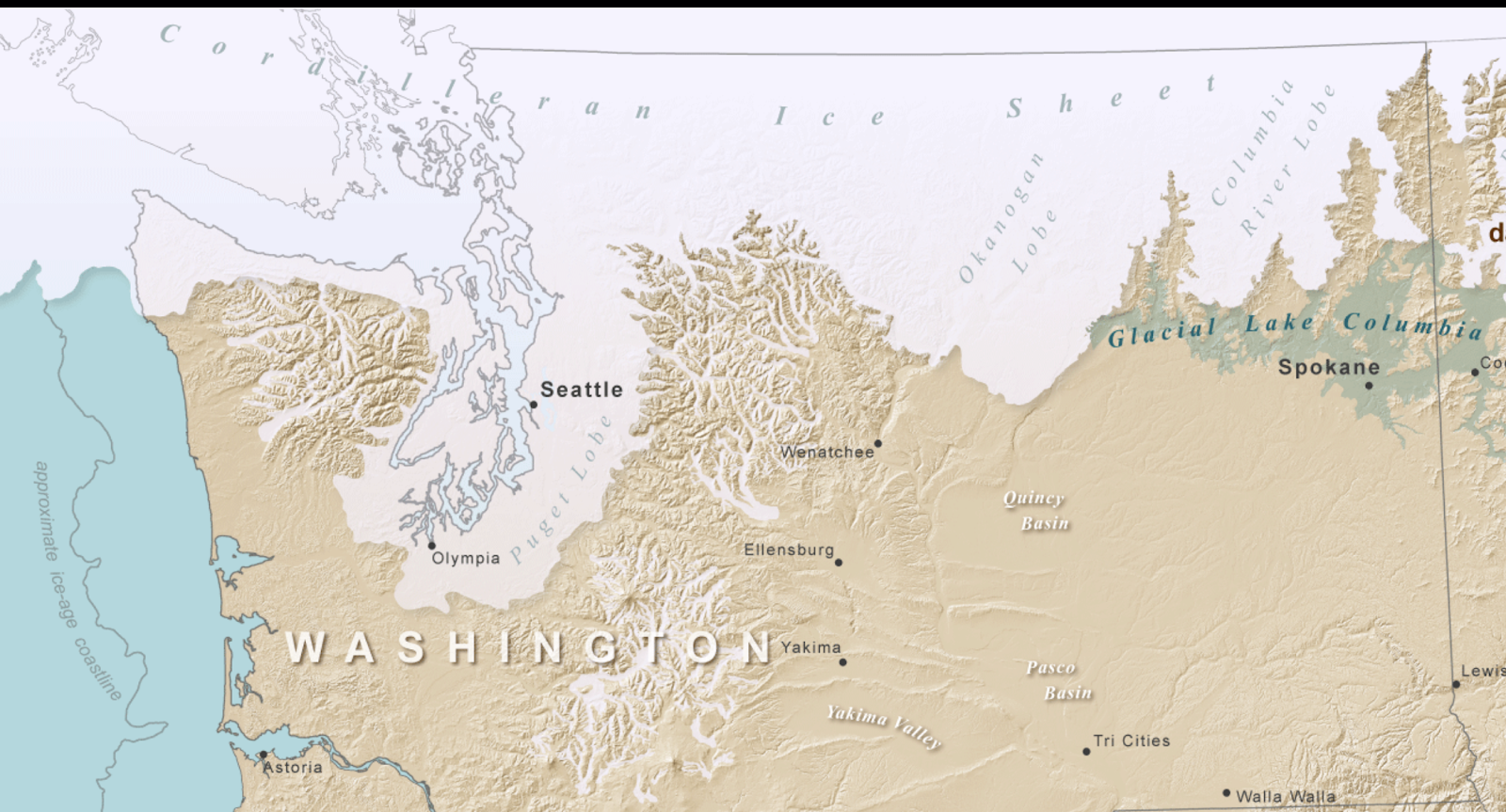
Why?  Because of the effects of the glaciers, which were thicker and heavier to the north.  The weight of glaciers pushed the land down...and it is still rebounding.


Let's consider how much sea level has changed at the Lummi Reservation near Bellingham.  There is a NOAA measurement site right there at Cherry Point (see below).

There is NO SEA LEVEL RISE.  In fact, sea level is FALLING slightly.  


Going further south, here is the sea level change at Friday Harbor.  Sea level is rising there...but much less than claimed by the Seattle Times.

How much?  About 1.2 mm a year, or about 4 inches in 86 years.  You will note the sea level trend is not increasing over time.  No acceleration due to global warming.


A good estimate of the rise of sea level over the Lummi domain would be an average of Bellingham and Friday Harbor, so about 2 inches in 86 years.  

That is about 0.023 inches per year.    

The Seattle Times suggested that sea level will rise about a foot by 2050 over Lummi lands.

Reality, based on the best observations, is 0.57 inches (.023* 23 years).  Yes, about HALF AN INCH.

This is what the Lummi Tribe will have to "race" against.

False information, exaggeration, and hype.  This is what advocate-funded "journalism" gets you.  

The Seattle Times is failing our community by promoting such misinformation.


June 18, 2025

March in June

 If you were thinking of going on a hike on Friday or Saturday, think again.

Early spring weather---cool and wet--will take over a few days starting on Friday.

Consider the predicted temperatures in Seattle (below).  Only 61F on Friday and 63F on Saturday.  Normal highs should be in the low 70s.


But if you want a real shocker, consider Stampede Pass at 4000 ft in the central Washington Cascades.  Highs only in the mid-40s and lows in the 30s on Friday and Saturday.


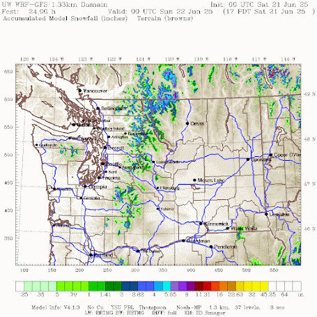
Are you sitting down?  The models are going for substantial SNOW above 5000 ft (see accumulated snowfall through Saturday evening below).


Even normally warm Yakima will get chilly, with lows in the 40s on Saturday and Sunday, with highs only reaching around 70°F for a few days.


Precipitation will be substantial for this time of the year, with the mountains getting hit particularly hard (see the predicted totals through Sunday at 5 AM below).  An inch in some places.


But the REALLY crazy precipitation will be in Oregon, where up to 3 inches will fall.  Nuts.

Why such unseasonable cold and wet weather?    An unusually strong upper-level Pacific low will move over our region on Friday and Saturday (see below)

This cool, moist period will help suppress any wildfire starts, resulting in a continuation of a BELOW-AVERAGE wildfire season in Washington State.   

Do me a favor....don't tell the Seattle Times ClimateLab folks about this....it will ruin their day.


Warming and Then Much Cooler for July 4

Time for the July 4th forecast, and we are close enough that skill should be good.   The bottom line:  current warming (caused by high press...